North Carolina Braces for Stormy Monday With Strong Thunderstorms, 45 MPH Wind Gusts and Mountain Snow Overnight
NORTH CAROLINA — A busy and potentially stormy Monday is unfolding across North Carolina as a strong cold front moves through the state, bringing scattered thunderstorms, gusty winds, and rapidly changing temperatures.
Forecasters say skies will remain mostly cloudy throughout the day, with scattered to numerous showers and thunderstorms developing across the state, some of which could become strong to severe as they move eastward. Outside of thunderstorms, residents can expect gusty winds between 30 and 45 mph, making it a blustery day across much of North Carolina.
Storms Expected Across Much of the State
Weather conditions across North Carolina will vary throughout the day, but the approaching cold front is expected to trigger multiple rounds of showers and thunderstorms. Some storms could intensify as they move through the state, bringing brief bursts of heavy rain, lightning, and strong winds.
Areas across the Piedmont and central North Carolina, including Charlotte, Greensboro, Durham, and Raleigh, may see thunderstorms during the afternoon hours as the system pushes east. Communities in the Cabarrus County and greater Charlotte region should remain alert for changing conditions as storms move through the area.
Windy Conditions Outside of Storms
Even outside of thunderstorms, the approaching cold front will bring persistent gusty winds across North Carolina. Meteorologists expect south winds between 15 and 30 mph, with occasional gusts reaching up to 45 mph in some locations.
These winds could cause minor tree damage, blow around unsecured outdoor objects, and make travel more difficult on open roadways.
Temperatures Climb Into the 60s and 70s
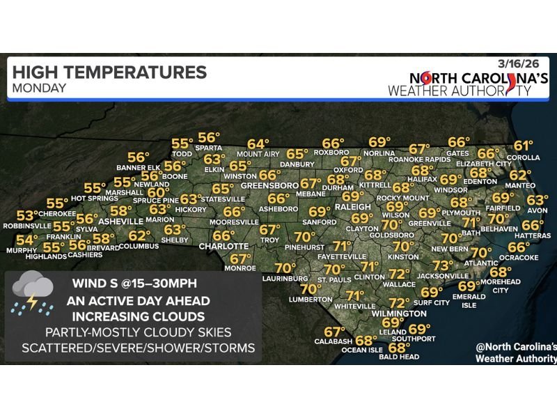
Despite the unsettled weather, temperatures across much of the state are expected to climb into the mid-60s to low-70s Monday afternoon.
Across the Piedmont region:
- Charlotte: around 66°F
- Greensboro: around 66°F
- Raleigh: near 69°F
- Durham: around 68°F
Farther east toward the coast, temperatures will be slightly warmer, with Jacksonville reaching about 73°F and Wilmington near 72°F. Mountain communities will remain cooler, generally in the 50s to low 60s.
Snow Possible in North Carolina Mountains Tonight
Once the cold front moves through later Monday, temperatures are expected to drop quickly overnight.
Forecasters say the colder air will allow precipitation in the North Carolina mountains — especially above 2,500 feet — to change to snow late Monday afternoon and into the overnight hours. Communities in higher elevations could see accumulating snow as the colder air settles across the region.
Conditions Improve After the Front Passes
As the cold front exits the state, skies are expected to gradually clear and temperatures will fall overnight. However, gusty winds and colder air will remain behind the front, especially across the mountains and foothills.
Residents across North Carolina are encouraged to stay weather aware throughout the day, especially during periods of thunderstorms and strong winds. Stay with CabarrusWeekly.com for continuing weather updates affecting Cabarrus County and communities across North Carolina.