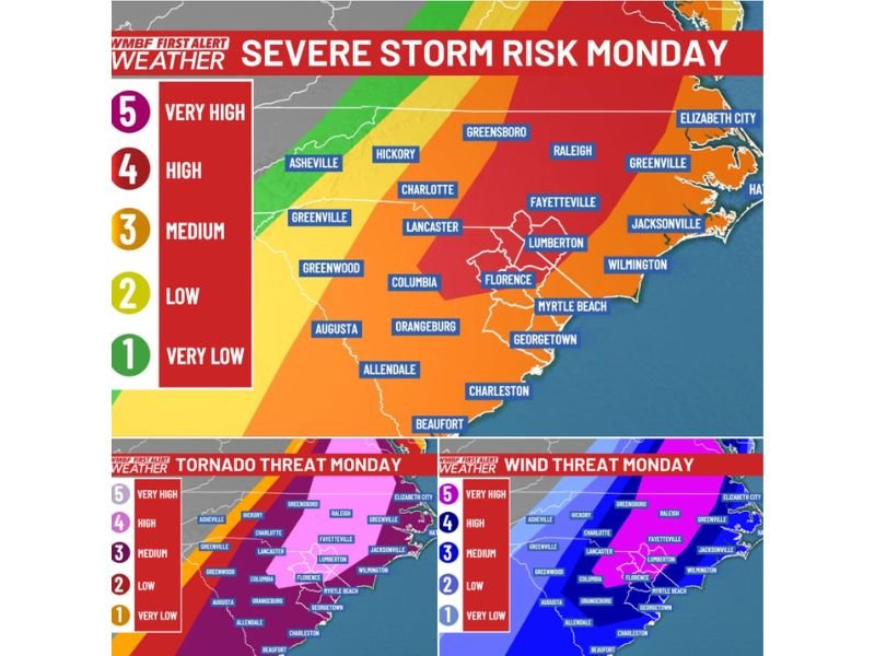
Central North Carolina Including Charlotte and Greensboro Faces Level 4 Severe Storm Risk With Possible Long-Track Tornadoes Monday
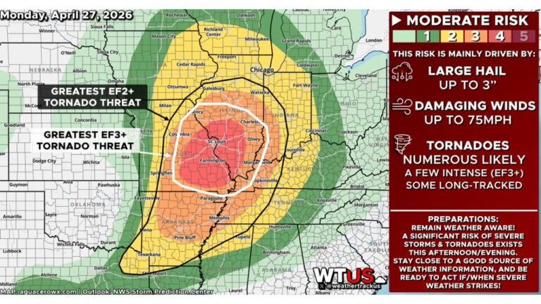
NORTH CAROLINA — A dangerous severe weather setup is unfolding across the Carolinas Monday morning, with forecasters maintaining a Level 4 high risk of severe storms stretching from the Pee Dee region into central North Carolina.
Meteorologists warn that the environment across this corridor could support strong tornadoes, destructive winds exceeding 70 mph, and multiple rounds of severe thunderstorms throughout the day.
The highest risk zone includes cities such as Charlotte, Greensboro, Hickory, Raleigh, and Fayetteville, placing millions of residents in the region on alert for rapidly changing weather conditions.
Highest Risk Focused Across Central North Carolina
Storm outlook maps show the Level 4 high-risk corridor extending through central North Carolina, including the Piedmont region.
Communities within the higher risk zone include:
- Charlotte
- Hickory
- Greensboro
- Raleigh
- Fayetteville
- Lumberton
This corridor represents the area where atmospheric conditions appear most favorable for tornado development and widespread damaging winds as storms move northeast across the region.
Tornado Threat Could Include Long-Track Storms
Meteorologists say tornadoes will be possible virtually anywhere across the Carolinas, but the greatest concern remains within the Level 4 risk area where the tornado threat is elevated.
Some of these tornadoes could potentially remain on the ground for extended periods if storms organize into stronger rotating systems. The storm environment is expected to support supercell thunderstorms capable of producing intense wind fields and tornado development.
Cities including Florence, Columbia, Myrtle Beach, Wilmington, and Jacksonville are also within areas where severe storms could develop as the system pushes toward the coast.
Damaging Winds Could Exceed 70 MPH
In addition to tornadoes, forecasters highlight an extreme damaging wind threat across much of the Carolinas, with a broad area of very high to high wind risk.
Some storm gusts could potentially exceed 70 mph, which could lead to:
- Downed trees
- Power outages
- Structural damage
- Hazardous travel conditions
The wind threat covers a wide region from South Carolina through central and eastern North Carolina, including cities like Columbia, Florence, Greenville, Wilmington, and Jacksonville.
Two Possible Rounds of Storms Today
Forecast discussions indicate that the storm system may produce multiple rounds of severe weather. The first round could develop during the mid-to-late morning hours, followed by a potential second round of storms during the afternoon as atmospheric instability increases.
Because of this evolving setup, the exact timing of storms may vary across communities, making it important for residents to stay alert throughout the day.
Coastal Areas Also Facing Severe Weather Risk
While the highest tornado threat is inland, coastal communities including Myrtle Beach, Wilmington, and Georgetown remain within areas where strong thunderstorms may move through later in the day. As storms shift toward the Atlantic coast, damaging winds and heavy rain may become the primary hazards.
Residents Urged to Stay Weather Aware
With a rare Level 4 severe storm risk in place across parts of North Carolina, residents are urged to closely monitor weather updates and be prepared to act quickly if warnings are issued.
Officials recommend having multiple ways to receive alerts and knowing the safest place to shelter should severe storms develop. Stay with CabarrusWeekly.com for continuing updates on severe weather impacting Cabarrus County and communities across North Carolina.