North Carolina and Mid-Atlantic Brace for Two Rounds of Severe Storms Monday Afternoon With Damaging Winds and Possible Tornadoes
NORTH CAROLINA — Forecasters are closely monitoring two separate rounds of storms expected to move across parts of the Southeast and Mid-Atlantic on Monday, with the greatest concern focused during the late afternoon between 3 p.m. and 6 p.m. when stronger storms may develop.
Warm, humid air has already surged across the region, pushing temperatures into the 60s across parts of the Carolinas and Virginia, creating an unstable atmosphere capable of fueling thunderstorms as a powerful weather system approaches from the west.
Meteorologists say the developing setup could bring damaging straight-line winds and the possibility of tornado activity as storms organize and sweep eastward.
First Round of Storms Developing West of the Carolinas
The first wave of storms is already forming across western Virginia, particularly near the Roanoke area, where severe thunderstorm warnings have been issued as storms begin to intensify.
These storms are expected to move northeast through parts of Virginia and toward the Washington DC region late this morning and around midday, with the highest early impact expected across areas west and north of the Capital Beltway.
While some storms in this early round may weaken as they move through, forecasters warn that isolated severe weather warnings could still be issued as the storms progress across the region.
Second Round Could Bring Stronger Storms Later in the Day
Behind the initial storms, meteorologists expect a second and potentially stronger line of storms to develop later in the afternoon.
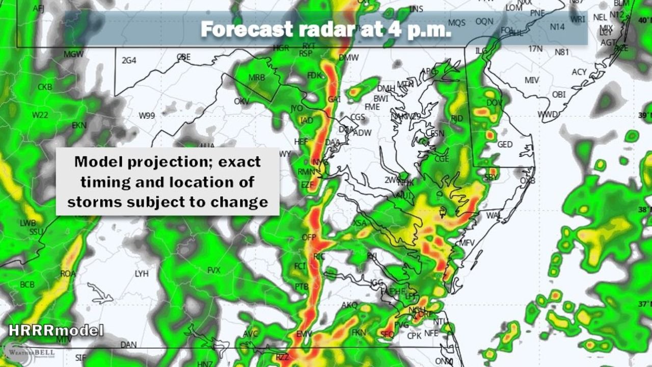
Forecast models indicate a line of thunderstorms forming west of the region before sweeping from west to east between roughly 3 p.m. and 6 p.m.
This second round of storms is considered the highest concern for severe weather, with conditions favorable for:
- Damaging straight-line winds
- Heavy rainfall
- Possible tornado development
Radar projections show a solid band of storms moving through Virginia, Maryland, and toward the Mid-Atlantic coast during this time frame.
Unstable Air Mass Fueling Storm Development
The severe weather potential is being driven by a surge of warm, humid air spreading northward ahead of the storm system, which has created the unstable conditions needed for strong thunderstorm development.
When this unstable air collides with incoming storms moving from the west, it can lead to rapid storm intensification, especially during the afternoon hours when daytime heating peaks.
This setup is often associated with fast-moving storm lines capable of producing strong wind gusts and brief tornadoes.
Timing and Locations Still Subject to Change
Meteorologists emphasize that the exact timing and location of the strongest storms may still shift, depending on how the earlier storms evolve through the morning hours.
Forecast models currently suggest the most organized storm line could move through the region during the late afternoon and early evening, but small shifts in the storm track could change when and where the strongest weather develops.
Residents across the Carolinas and the Mid-Atlantic are encouraged to stay alert for changing weather conditions and possible severe weather alerts throughout the day.
Stay with CabarrusWeekly.com for continuing updates as meteorologists track this developing severe weather threat across North Carolina and the surrounding region.