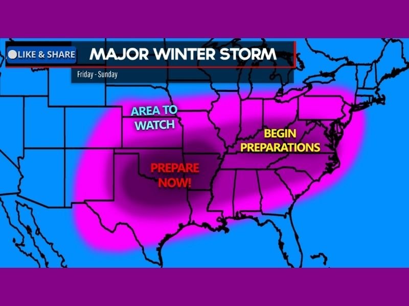
High-Impact Winter Storm Targets Texas, Oklahoma, Arkansas, Tennessee, and the Carolinas With Dangerous Ice, Heavy Snow, and Widespread Power Outage Risk
UNITED STATES — A major and potentially dangerous winter storm is increasingly likely to impact a large portion of the southern and eastern United States beginning Friday, with Texas, Oklahoma, Arkansas, Tennessee, Mississippi, Alabama, Georgia, and the Carolinas all facing the risk of significant ice accumulation, heavy snow, and extreme cold through the weekend.
Confidence Growing in a Widespread, High-Impact Setup
Forecast confidence continues to increase that a strong storm system will develop and track eastward, interacting with deep Arctic air already in place. While exact storm placement is still being refined, confidence is high that a disruptive winter weather event will occur somewhere across the South and Southeast.
Even small shifts in the storm track could dramatically change impacts from cold rain to crippling ice or heavy snow, which is why preparations are being urged now.
Ice Storm Threat Expands Across the Deep South
The most concerning aspect of this system is the potential for widespread freezing rain, particularly across Texas, Arkansas, Mississippi, Alabama, Georgia, South Carolina, and parts of North Carolina.
Ice accumulation in these areas could be significant enough to cause power outages, tree damage, and extremely dangerous travel conditions. Freezing rain is especially hazardous in the South, where infrastructure is less equipped to handle prolonged icing events.
Heavy Snow Likely North of the Ice Zone
Farther north, heavy snow is increasingly likely across parts of Oklahoma, Arkansas, Tennessee, Kentucky, North Carolina, and Virginia, where colder air will support snow instead of ice.
Some locations may see plowable to potentially major snowfall totals, especially if banding sets up on the northern side of the storm. Snowfall amounts will become clearer as the event gets closer.
Extreme Cold Adds to the Danger
Behind the storm, Arctic air is expected to surge southward, bringing dangerously cold temperatures well into the Deep South. This raises concerns for pipe bursts, extended power restoration issues, and prolonged hazardous road conditions even after precipitation ends. In some areas, cold conditions may linger into early next week, slowing recovery efforts.
Timing: Friday Through Sunday
Current guidance suggests winter impacts could begin as early as Friday, intensify Saturday, and linger into Sunday or Sunday night, depending on location. Travel conditions may deteriorate rapidly once precipitation begins, especially in areas experiencing freezing rain.
Why Preparations Should Begin Now
With the potential for power outages, major travel disruptions, and infrastructure stress, residents across the affected states are urged to prepare now rather than wait for last-minute warnings.
Best-case outcomes involve cold rain or lighter icing, but worst-case scenarios include long-lasting ice storms capable of knocking out power for days, especially across the Deep South.
What to Watch Going Forward
Over the next 24–48 hours, meteorologists will focus on:
- Refining the exact storm track
- Pinpointing the ice versus snow transition zone
- Determining where the highest impact corridor will set up
Updates will continue as forecast confidence improves.
If you live anywhere from Texas to the Carolinas, now is the time to monitor forecasts closely, limit unnecessary travel plans, and prepare for potential power and transportation issues. Share your local preparations or weather conditions with the Cabarrus Weekly community at CabarrusWeekly.com.