Southeast Oklahoma, Western Arkansas and North Texas Face Damaging Hail and Tornado Threat Saturday April 26
SOUTHEAST OKLAHOMA AND NORTH TEXAS — Multiple areas across southeast Oklahoma, western Arkansas, and North Texas are facing an all-hazards severe weather threat Saturday, April 26, 2026, with damaging hail as the dominant concern and tornado potential present across all three zones depending on how storms evolve through the afternoon and evening.
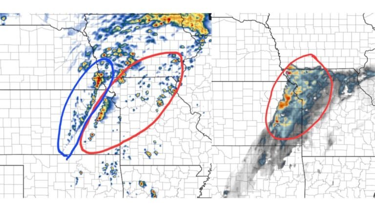
Southeast Oklahoma — Cyclic Supercells Possible
The primary focus across southeast Oklahoma is the potential for one or a few cyclic supercells — long-lived rotating storms capable of producing repeated cycles of damaging hail and tornadoes. The environment carries significant hail potential and an elevated tornado threat if storms can remain discrete and avoid upscale growth into a messy cluster.
Two key variables will determine the tornado outcome here. Upscale growth — where individual supercells merge into a larger storm cluster — could suppress overall tornado potential. Outflow dominance, where storms become driven by their own cold air production rather than environmental inflow, is also being watched closely as a limiting factor.
Eastern Oklahoma and Western Arkansas — All Hazards Threat
Cells already developing across eastern Oklahoma and western Arkansas are carrying an all-hazards severe weather threat — meaning damaging hail, damaging winds, and tornadoes are all on the table. Tornado potential specifically depends on whether storms can access sufficient inflow and avoid being undercut by outflow boundaries from earlier activity.
North Texas — Damaging Hail and Isolated Tornado Threat
North Texas is identified as an additional area requiring close monitoring, with damaging hail and isolated tornado potential possible with any additional storm development through the afternoon. This threat is secondary but real and should not be dismissed.
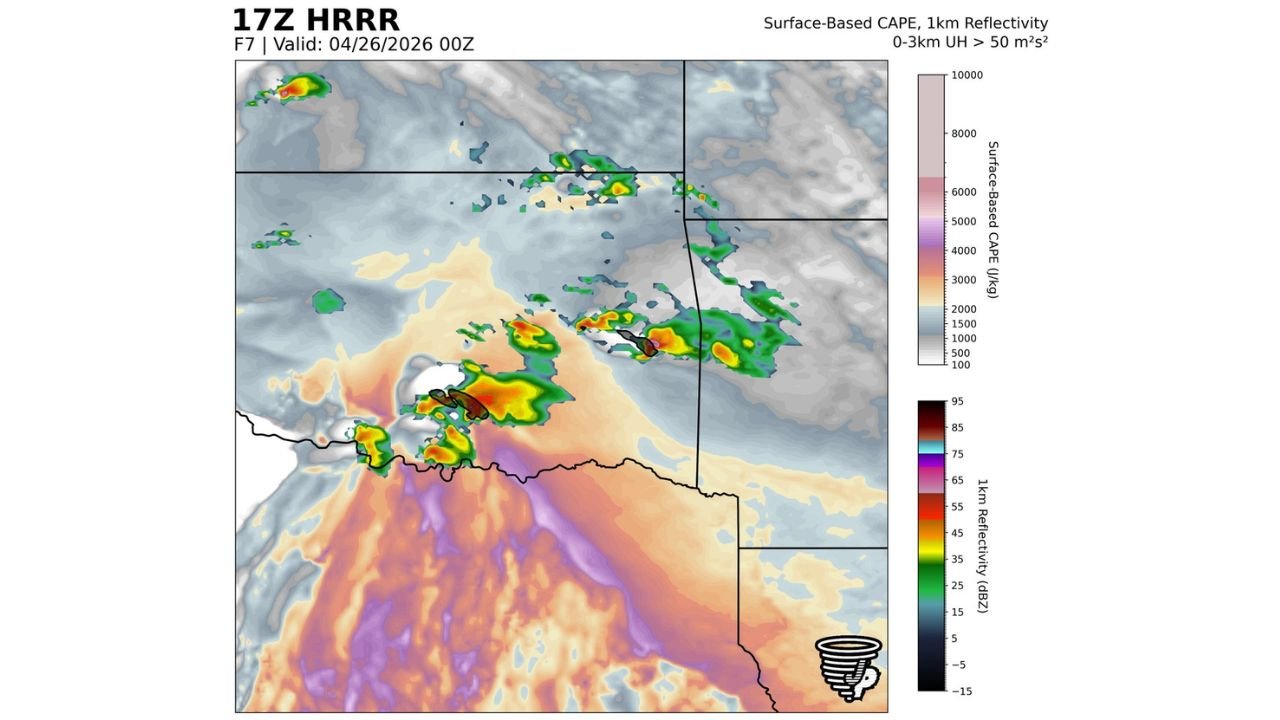
What the Model Guidance Shows
The HRRR valid at April 26 at 00Z shows surface-based CAPE values in the orange to red range — indicating 1,500 to 4,000-plus J/kg of instability — across southeast Oklahoma and into North Texas. Multiple storm cells with 0 to 3 km updraft helicity exceeding 50 m²/s² are depicted, confirming rotating updrafts capable of producing tornadoes across the region.
Primary Threats by Zone
| Zone | Primary Threats |
|---|---|
| Southeast Oklahoma | Cyclic supercells, damaging hail, tornadoes — depends on storm mode |
| Eastern Oklahoma and western Arkansas | All hazards — hail, winds, tornadoes — depends on inflow access |
| North Texas | Damaging hail, isolated tornado with additional development |
Residents across southeast Oklahoma, the eastern Oklahoma and western Arkansas border region, and North Texas should monitor conditions closely through the afternoon and evening and have shelter plans ready before any storms approach.
Stay with CabarrusWeekly.com for continuing coverage of Saturday’s severe weather threat across Oklahoma, Arkansas, and Texas.