North Carolina South Carolina Fire Danger Alert Dry Air Strong Winds And Cold Front Create Rapid Wildfire Risk Across Charlotte Region Today
NORTH CAROLINA — A dangerous fire weather setup is unfolding across the Carolinas today, as a combination of extremely dry air, gusty winds, and a passing cold front creates conditions favorable for rapid wildfire spread across the region.
Dry Air and Low Humidity Driving Critical Conditions
Forecast data shows relative humidity levels dropping significantly across North Carolina and South Carolina, especially inland areas away from the immediate coast.
Many locations are expected to see:
- Humidity values falling into the 20–35% range
- Even drier pockets in parts of western and central North Carolina
This dry air allows vegetation—especially dormant winter fuels—to become highly flammable, increasing the likelihood of fires starting and spreading quickly.
Cold Front Enhancing the Risk
A dry cold front pushing southward across the Carolinas is a key driver behind today’s fire danger.
Behind and along this boundary:
- Air becomes even drier
- Winds shift and increase
- Fire spread potential rises rapidly
Unlike rain-producing fronts, this system is largely moisture-starved, meaning it brings wind and dryness instead of beneficial rainfall.
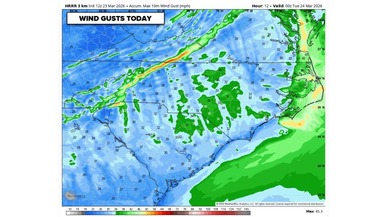
Gusty Winds Could Spread Fires Quickly
Wind guidance shows widespread gusts between 25 and 40 mph, with isolated higher gusts possible.
These winds can:
- Rapidly push flames across dry grass and brush
- Carry embers long distances, sparking new fires
- Make containment efforts much more difficult
The strongest gusts are expected across central and eastern North Carolina, including areas near Charlotte and surrounding counties.
Why Today’s Setup Is Especially Dangerous
Several factors are aligning at once, creating a high-end fire weather day for the region:
- Dry, dormant vegetation from winter
- Very low humidity levels
- Strong, sustained winds with higher gusts
- A passing dry cold front enhancing instability
When all these elements combine, even a small spark—from equipment, vehicles, or outdoor burning—can quickly turn into a fast-moving wildfire.
Areas Most at Risk
The highest concern includes:
- Charlotte metro area and surrounding Piedmont region
- Central North Carolina counties
- Upstate South Carolina
While coastal areas may retain slightly higher humidity, inland regions face the greatest wildfire spread potential.
Safety Warnings and Precautions
Officials are strongly urging residents to take precautions today:
- Avoid any outdoor burning
- Properly dispose of cigarettes and flammable materials
- Secure trailer chains and equipment that may spark
- Report any smoke or fire immediately to local authorities
Fire officials emphasize that fires can spread rapidly under today’s conditions, leaving little time to react once ignition occurs.
What Happens Next
Conditions are expected to gradually improve after today as:
- Winds ease slightly
- Humidity begins to recover
- The front moves farther south
However, until those changes occur, today remains a critical window for wildfire risk across North Carolina and South Carolina.
Final Outlook
A high fire danger alert is in effect across the Carolinas today, with dry air, gusty winds, and a passing cold front creating ideal conditions for rapid wildfire growth.
Residents across the Charlotte region and surrounding areas should remain alert and avoid any activities that could spark a fire.
Stay with CabarrusWeekly.com for continued updates on fire weather conditions and regional safety alerts.