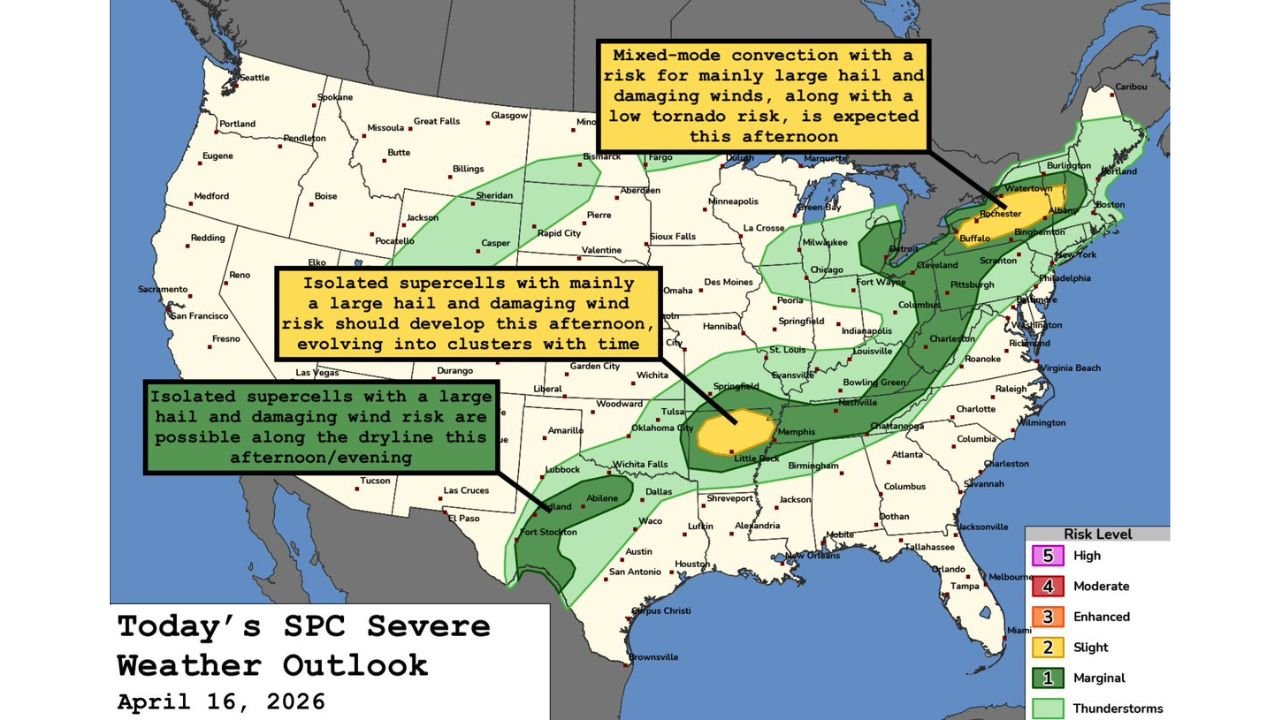
Three Separate Severe Weather Zones Fire Across the U.S. Today: New York, Arkansas, and Texas All at Risk
UNITED STATES — Thursday April 16, 2026 brings severe weather to three completely separate parts of the country simultaneously. From New York and Vermont in the Northeast down to northern Arkansas in the mid-South and across to west and northwest Texas along the dryline — large hail, damaging winds, and isolated tornado risks are active today from coast to interior. None of these three zones are connected — each is its own independent severe weather setup firing at the same time.
Three Zones — Three Different Threats
| Zone | Risk Level | Primary Hazards |
|---|---|---|
| New York and Vermont | Slight — Level 2/5 | Large hail, damaging winds, low-end tornado risk |
| Northern Arkansas | Slight — Level 2/5 | Large hail, damaging winds, very low-end tornado risk |
| West and Northwest Texas | Marginal — Level 1/5 | Large hail, damaging winds along the dryline |
Zone 1 — New York and Vermont carries the highest concern today. A mix of supercells and line segments is expected this afternoon bringing mainly damaging winds and large hail along with a low-end tornado risk. Cities across the Buffalo, Rochester, Albany, and Burlington corridor need to be weather-aware this afternoon.
Zone 2 — Northern Arkansas sees isolated supercells developing and evolving into clusters through the day. The main threats are large hail and damaging winds with a very low-end tornado risk. Little Rock and surrounding northern Arkansas communities should monitor conditions through the afternoon and evening.
Zone 3 — West and Northwest Texas faces an isolated supercell threat along the dryline this afternoon and evening. The risk is large hail and damaging winds from any storm that can develop and sustain itself. Amarillo, Lubbock, Wichita Falls, and Woodward areas are the primary watch zones.
Timing for Each Zone
- New York and Vermont — mixed-mode convection expected this afternoon
- Northern Arkansas — supercells develop this afternoon, evolving into clusters with time
- West Texas dryline — isolated supercells possible this afternoon through evening
What to Do If You Are in Any of These Zones
Large hail can damage vehicles and rooftops with zero warning time — get cars under cover before storms approach. Damaging winds can knock out power instantly — charge devices now. Even a low-end tornado risk is still a tornado risk — know your shelter location before storms arrive.
Stay with CabarrusWeekly.com for live severe weather updates across all three active zones today.