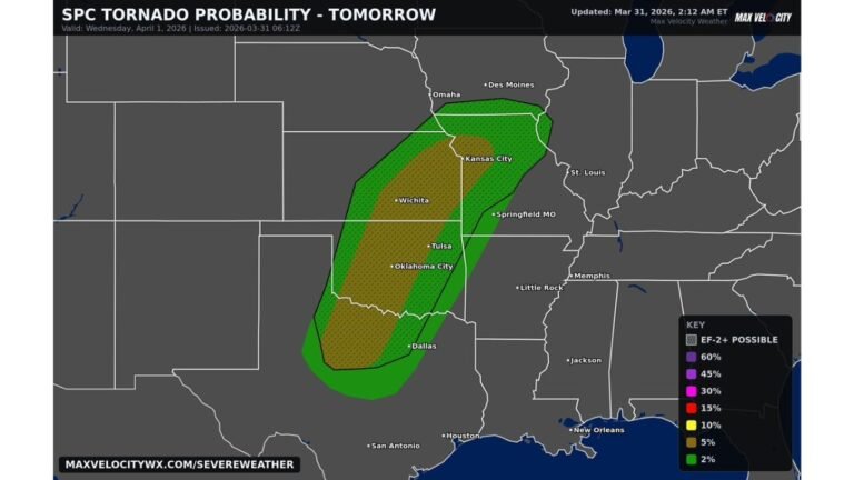
Texas, Oklahoma, Arkansas, Missouri, Tennessee and Mississippi Valley Braced for Early April Severe Storm Pattern With Tornado and Heavy Rain Risk
UNITED STATES — Confidence is increasing in a major pattern shift heading into early April, one that could bring a more active stretch of severe weather and heavy rainfall across the central and southern United States after a relatively quiet period.
Quiet Pattern Set to Break as April Begins
Over the past week, much of the country has experienced relatively calm weather conditions. However, as the calendar flips into April, meteorological signals are pointing toward a more active and potentially volatile setup.
While it is still too early to pinpoint exact storm days or locations, broader trends suggest an uptick in severe weather potential across multiple states.
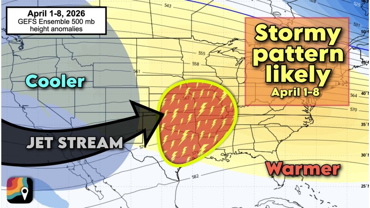
Jet Stream Shift Sets the Stage
A key driver behind this change will be a large-scale pattern reversal in the upper atmosphere.
Forecast models show:
- A deep trough developing over the western United States
- A strong jet stream dipping south across the Rockies
- Energy ejecting eastward into the Plains and Mississippi Valley
This setup is critical because it introduces cooler air from the west while allowing warm, moist air to surge northward from the Gulf of Mexico.
Severe Weather Risk Expands Across Central U.S.
As these ingredients combine, the environment becomes increasingly favorable for storm development.
Regions most at risk include:
- Texas and Oklahoma
- Arkansas and Missouri
- Tennessee and the lower to mid Mississippi Valley
These areas could see:
- Strong to severe thunderstorms
- Damaging winds and large hail
- Increasing tornado potential as the pattern evolves
The presence of strong upper-level winds will add shear and energy, increasing the likelihood that some storms could become organized and intense.
Heavy Rainfall Also Likely
In addition to severe storms, this pattern favors above-average rainfall totals.
With repeated disturbances moving through:
- Storms may track over the same regions multiple times
- Localized areas could experience heavy downpours and flooding concerns
This is especially important for parts of the Mississippi Valley, where moisture will be abundant.
Why This Pattern Is Concerning
The combination of factors expected in early April is a classic severe weather setup:
- Warm, humid air building across the East and South
- Cold air intruding from the West
- A strong, active jet stream overhead
As smaller disturbances rotate through this larger pattern, they can trigger multiple rounds of storms, some of which may become severe.
Additionally, early April is a time of year when tornado activity typically begins ramping up across the U.S., making this setup even more noteworthy.
Timing and Uncertainty Still Remain
It’s important to note that this outlook is based on probabilistic forecasting, not exact predictions.
That means:
- Specific storm days are still uncertain
- Exact locations of severe weather will shift as models refine
- Not every area within the broader region will see severe conditions
However, the overall signal is strong enough to highlight increasing confidence in an active period ahead.
Preparedness Is Key
With the potential for severe weather increasing:
- Now is a good time to review emergency plans
- Ensure access to weather alerts and warnings
- Prepare for possible rapid weather changes
Early awareness can make a significant difference as the pattern evolves.
Final Outlook
The first week of April is shaping up to bring a notable transition toward a more storm-active pattern across the central United States, particularly from Texas through the Mississippi Valley.
With warmth, moisture, and jet stream energy aligning, the stage is being set for multiple rounds of thunderstorms, heavy rain, and a possible increase in tornado activity.
Stay with CabarrusWeekly.com for continued updates as this developing severe weather pattern becomes clearer in the days ahead.