Texas, Oklahoma, Arkansas, Tennessee, Carolinas, Virginia and Mid-Atlantic States Face Multi-Phase Winter Storm With Snow, Ice and Dangerous Cold
UNITED STATES — A sprawling and increasingly complex winter weather pattern is taking shape across the central and eastern United States, with forecast guidance pointing to multiple rounds of snow, freezing rain, and hazardous cold impacting states from Texas and Oklahoma through the Tennessee Valley, the Carolinas, the Mid-Atlantic, and New England over the coming days.
Meteorologists are monitoring a setup that includes very cold air already in place, followed by a brief moderation mid-week, before another surge of Arctic air arrives alongside a developing storm system late Friday into the weekend. While this event is not expected to mirror the historic February 2021 Texas freeze, confidence is growing that travel disruptions, icy roads, and localized infrastructure impacts are likely in several regions.
Storm Timeline: Cold Holds, Brief Break, Then Renewed Winter Threat
Very cold air will remain entrenched across large portions of the country through the early part of the week. Some moderation in temperatures is expected Wednesday and Thursday, but forecast models consistently show cold air quickly returning as the weekend system develops.
Current projections suggest:
- Late Friday into early Sunday as the primary window for wintry impacts
- Snow and ice expanding eastward as the system strengthens
- Prolonged cold lingering even after precipitation ends in some areas
Forecasters caution that timing and exact placement will continue to evolve, but enough ingredients are present to support a high-impact winter setup.
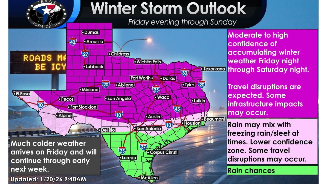
Texas and Southern Plains: Snow, Ice and Travel Disruptions Possible
Across Texas and southern Oklahoma, confidence is increasing that accumulating winter precipitation will develop late Friday and continue into Saturday night, particularly across north and central Texas.
Forecast signals highlight:
- A mix of snow, sleet, and freezing rain in parts of Texas
- The highest travel risk across the northern half of the state
- Icy roads developing overnight, with some periods potentially impassable
While not comparable to 2021 in scale or severity, officials emphasize that any ice combined with prolonged cold can still strain travel and infrastructure, especially in regions less accustomed to winter storms.
Central U.S. to Appalachians: Expanding Snow Axis
As the system moves east, snow probabilities increase from Oklahoma and Arkansas into the Tennessee Valley and the southern Appalachians. Ensemble guidance shows a broad swath with a meaningful chance of 6 inches or more, though exact totals remain uncertain.
Key areas of concern include:
- Southern Oklahoma and northern Arkansas
- The Cumberland Plateau
- Higher elevations of Tennessee, Kentucky, and West Virginia
Forecasters stress the importance of the word “chance”, noting that ensemble models represent a range of outcomes rather than a single guaranteed solution.
Carolinas, Virginia and the Mid-Atlantic: Snow and Freezing Rain Overlap
One of the more concerning signals is the overlap of heavy snow and freezing rain potential across portions of the Carolinas and Virginia. Hazard outlooks indicate:
- A corridor of freezing rain risk embedded within a broader snow zone
- Increased chances of power disruptions where ice accretes on trees and lines
- Snow probabilities increasing from western North Carolina into Virginia
This mixed-precipitation setup heightens the risk for dangerous travel and scattered outages, especially if cold air remains locked in longer than expected.
Northeast and New England: Snow Potential Builds
Farther northeast, snowfall maps favor widespread accumulations across parts of the Mid-Atlantic, New York, and New England, with locally higher totals possible in interior and elevated areas.
Some coastal locations may see lower totals due to mixing, but inland zones could experience:
- Several inches of snow over a broad area
- Locally higher amounts where banding sets up
- Lingering cold following the storm
Forecasters note that not everyone within highlighted zones will see major totals, but confidence is growing in a region-wide winter impact.
Cold Air Lingers After the Storm
Beyond precipitation, hazardous cold remains a major concern. Outlooks show below-normal temperatures persisting across much of the central and eastern U.S., which can:
- Prolong icy conditions
- Stress infrastructure and utilities
- Increase risks to pets, pipes, and vulnerable populations
Preparation Urged as Details Continue to Evolve
With several days still remaining, meteorologists emphasize that the axis of heaviest snow and ice will likely shift as new data arrives. Residents across affected states are encouraged to:
- Monitor updated forecasts frequently
- Be prepared to adjust travel plans
- Protect people, pets, pipes, and plants
- Ensure multiple ways to receive weather alerts
This remains a high-confidence winter pattern with moderate uncertainty on exact placement, and additional refinements are expected as the weekend approaches.
Stay tuned to Cabarrusweekly.com for continued winter weather coverage, updated impact zones, and clear breakdowns as this evolving storm system comes into sharper focus.