Ohio and Pennsylvania Including Cleveland, Pittsburgh Under Level 3 Enhanced Severe Thunderstorm Risk With Damaging Winds, Hail and Tornado Potential Tonight
OHIO VALLEY — A Level 3 out of 5 Enhanced Risk for severe thunderstorms is in place tonight, impacting parts of Ohio and Pennsylvania, including major cities like Cleveland and Pittsburgh.
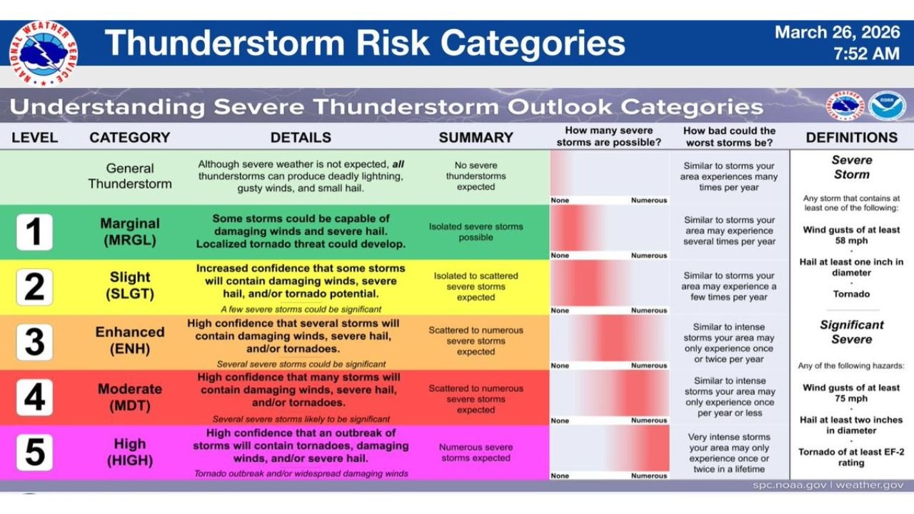
What Level 3 Enhanced Risk Means
A Level 3 Enhanced Risk indicates a higher confidence in numerous severe storms developing, with the potential for multiple hazards occurring across a wide area.
In this category, storms are more likely to produce damaging winds, large hail, and possible tornadoes, with some storms capable of becoming significant.
This level represents a step above the more common slight risk, signaling a more organized and impactful severe weather setup.
Areas Under the Highest Threat
The enhanced risk zone covers much of northern and central Ohio extending into western Pennsylvania, including Cleveland, Akron, Youngstown, and Pittsburgh.
Communities within this region should prepare for scattered to numerous severe thunderstorms, especially during the evening hours.
Surrounding regions may still experience storms, but the highest concentration of severe activity is expected within this corridor.
Main Threats With Tonight’s Storms
Storms developing in this environment may produce damaging wind gusts capable of causing power outages and tree damage.
There is also a risk for large hail, which could lead to damage to vehicles and property.
Additionally, isolated tornadoes cannot be ruled out, particularly where storms become more organized.
The combination of these hazards makes this a multi-threat severe weather event.
Timing Focused on Evening and Overnight Hours
The most active period for severe weather is expected to occur during the evening into the overnight hours, when storms are likely to intensify.
This timing increases the risk for dangerous conditions after sunset, when visibility is lower and storms may be harder to track.
Residents should ensure they have a way to receive alerts, especially during the nighttime hours.
Understanding the Severe Weather Setup
This situation is driven by a classic spring pattern, where warm, unstable air interacts with an approaching system, creating favorable conditions for storm development.
The enhanced risk classification reflects confidence in both storm coverage and intensity, meaning impacts could be widespread rather than isolated.
Residents across Ohio and Pennsylvania are urged to remain weather-aware, review safety plans, and be ready to take action if warnings are issued.
Residents are encouraged to share conditions in their area and stay updated with the latest alerts on CabarrusWeekly.com.