Illinois, Indiana, Ohio Under Enhanced Severe Storm Risk as Damaging Winds, Large Hail and Tornado Threat Builds Thursday
ILLINOIS, INDIANA, OHIO — A significant severe weather setup is unfolding across the Midwest, where a Level 3 out of 5 enhanced risk is now in place from central Illinois through Indiana into Ohio, signaling a growing threat for dangerous storms later today.
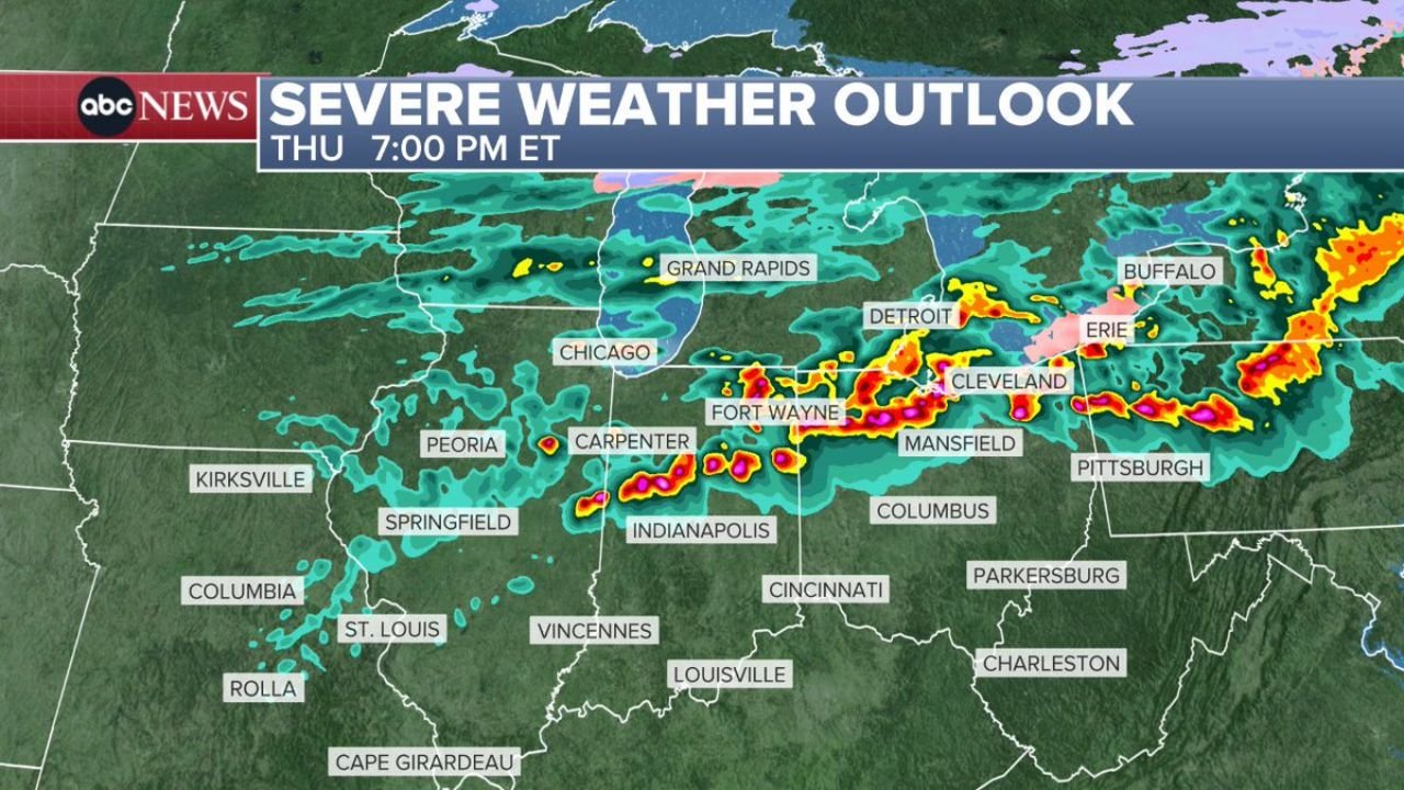
Enhanced Risk Zone Targets Major Midwest Cities
The highest concern zone stretches across key population centers including Peoria and Springfield in Illinois, along with Fort Wayne and Indianapolis in Indiana, and extending into Columbus, Ohio.
This corridor represents the most favorable environment for organized severe thunderstorms capable of producing widespread impacts.
Surrounding this area, a Level 2 slight risk includes cities such as Chicago, Detroit, Cleveland, and Pittsburgh, where storms may still turn severe but with slightly lower coverage.
Primary Threats Include Hail, Damaging Winds and Tornadoes
Storms developing across this region are expected to carry multiple hazards. The main concerns include:
- Damaging wind gusts capable of causing power outages and tree damage
- Large to very large hail, potentially exceeding golf ball size
- Isolated tornadoes, especially within stronger storm cells
- Flash flooding risk due to repeated rounds of heavy rainfall
This combination makes the setup particularly dangerous, especially during the peak evening hours.
Timeline Shows Storms Moving East Through the Evening
The timing of storms will vary across the region, but current projections indicate a west-to-east progression throughout the day and night.
- Chicago and Detroit may begin to see initial storm activity during the afternoon hours
- The most intense storms are expected from Fort Wayne to Cleveland during late afternoon into early evening
- Storms will then push farther south and east, reaching Indianapolis, Columbus, and Pittsburgh later tonight
This evolving timeline suggests that multiple areas could experience severe weather at different points through the evening.
Heavy Rain Expands Toward the East Coast Overnight
As the system continues moving east, the severe threat is expected to weaken, but rain and thunderstorms will spread into the Northeast corridor.
Cities from New York City to Boston could see rain arriving after 9 PM, with wet conditions continuing into Friday morning.
While these storms may be less severe, periods of steady rainfall could still impact travel and morning commutes.
A High-Impact Evening Ahead for the Midwest
With a well-defined enhanced risk zone and multiple severe hazards in play, this setup has the potential to bring impactful weather across several states in a short period of time.
Residents across Illinois, Indiana, and Ohio should remain alert, especially during the evening hours when storms are expected to intensify.
Stay updated with local alerts and be prepared to take action if warnings are issued. Share conditions in your area and follow the latest updates on CabarrusWeekly.com.