North Carolina Fire Weather Outlook: Elevated Fire Risk Across Winston-Salem, Greensboro, Charlotte, and Raleigh Saturday With Very Low Humidity
NORTH CAROLINA — Residents across a large portion of North Carolina are being urged to avoid all outdoor burning on Saturday, March 28, 2026, as very low humidity and elevated fire weather conditions create a dangerous environment where fires can ignite and spread rapidly.
While no official burn ban is currently in effect, meteorologists are sending a clear message: do not burn.
Why Saturday Is Dangerous for Fires
Two critical factors are combining to create elevated fire weather conditions across much of North Carolina on Saturday.
Very low humidity is the primary driver. When relative humidity drops to critically low levels, vegetation and other combustible materials dry out rapidly, making them far more susceptible to ignition. Even a small spark can quickly develop into a fast-moving fire under these conditions.
Wind adds to the concern. Any breeze present Saturday will allow fires to spread quickly in multiple directions, making containment difficult once a fire starts.
These conditions do not require an official burn ban to be dangerous. Forecasters are urging residents to use common sense and hold off on any burning until conditions improve.
Areas Under Elevated Fire Risk Saturday
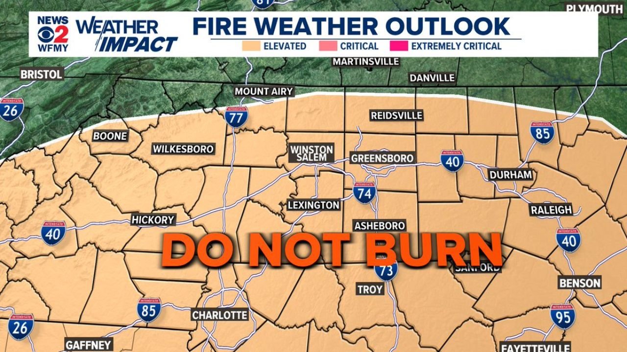
According to the WFMY News 2 Weather Impact Fire Weather Outlook, the following areas are under an elevated fire weather risk for Saturday:
| Area | Risk Level |
|---|---|
| Winston-Salem | Elevated |
| Greensboro | Elevated |
| Reidsville | Elevated |
| Lexington | Elevated |
| Asheboro | Elevated |
| Charlotte | Elevated |
| Hickory | Elevated |
| Boone | Elevated |
| Wilkesboro | Elevated |
| Mount Airy | Elevated |
| Durham | Elevated |
| Raleigh | Elevated |
| Sanford | Elevated |
| Troy | Elevated |
| Fayetteville | Elevated |
| Benson | Elevated |
Forecast Confidence Level
High confidence on the elevated fire weather conditions Saturday — low humidity and fire-favorable winds are well-established in the forecast.
High confidence on the geographic coverage — the elevated risk zone covers a wide swath of central and western North Carolina, from the foothills through the Piedmont and into the eastern counties.
What North Carolina Residents Must Know Saturday
Do not burn anything outdoors on Saturday — this includes yard debris, brush piles, campfires, and burning barrels. Even a small fire can escape control quickly under these conditions.
Be careful with anything that produces sparks — equipment, vehicles, and power tools operating near dry vegetation all carry risk on a day like Saturday.
If you see a fire, call 911 immediately — do not attempt to fight a spreading fire on your own. Fast-moving fires in low humidity conditions can outpace expectations within minutes.
Keep water accessible — if you are outdoors in a rural area, make sure water is on hand as a precaution.
Check back for updates — while no official burn ban is in place as of this report, conditions could prompt local authorities to issue restrictions at any time Saturday.
The Bottom Line
North Carolina is facing elevated fire weather conditions Saturday due to very low humidity across a large portion of the state. From Winston-Salem and Greensboro to Charlotte, Raleigh, and Fayetteville, the message from forecasters is direct: do not burn. No official burn ban is in effect, but the risk is high enough that any outdoor burning is strongly discouraged until further notice.
Bookmark cabarrusweekly.com and turn on notifications so you never miss a weather update, fire weather alert, or severe weather report across the United States — delivered daily, before the weather hits.