Maryland, Pennsylvania, Virginia Face 80s Heat Surge Followed by Thunderstorm Line and Late-Week Chilly Northeast Air Shift
MARYLAND — A volatile spring pattern is setting up across the Mid-Atlantic this week, with summer-like warmth surging into the 80s by midweek, followed by strong thunderstorms and a sharp cooldown as chilly northeast air pushes in.
Warm Surge Builds Across the Mid-Atlantic
The data shows a pronounced warm sector expanding across Maryland, Virginia, and southern Pennsylvania, with temperatures climbing into the upper 70s and low to mid 80s by Tuesday and Wednesday.
This early-season warmth is being driven by strong southwest flow ahead of an approaching system, allowing much of the region—including Baltimore and surrounding areas—to experience conditions more typical of late spring or early summer.
By Wednesday afternoon, central and eastern Virginia and much of Maryland could peak near or above 80°F, marking one of the warmest stretches so far this season.
Thunderstorm Line Develops Wednesday Evening
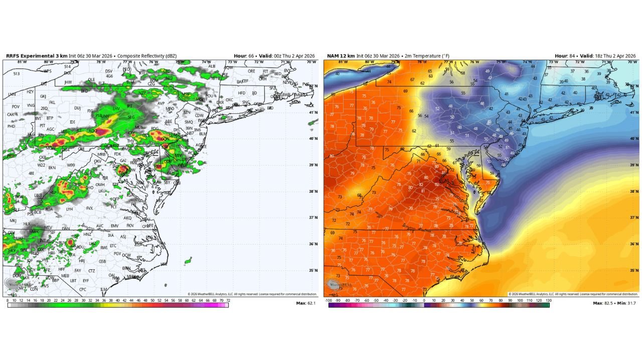
As the warm air mass peaks, the atmosphere becomes increasingly unstable. Model reflectivity data indicates a well-organized line of thunderstorms developing Wednesday evening, stretching from western Pennsylvania through Maryland and into Virginia.
This line appears capable of producing heavy rain, strong wind gusts, and frequent lightning, especially as it moves eastward toward the I-95 corridor.
Baltimore sits in a particularly sensitive zone where the storm line may still be strong but beginning to transition, increasing the risk of brief but intense impacts during the evening hours.
The setup suggests a classic spring transition event, where warmth and instability quickly give way to a passing disturbance.
Sharp Temperature Drop Follows the Storms
Behind the storm system, a dramatic shift in air mass takes over. Temperature maps show a clear divide, with cooler air surging in from the northeast by Thursday.
While areas ahead of the front remain in the 70s and low 80s, regions behind it—including parts of Pennsylvania, northern Maryland, and New Jersey—drop into the 40s and 50s.
This creates a sharp gradient across the region, with Baltimore and surrounding areas positioned right along the edge of the cooling boundary.
By late Thursday into Friday, the influence of this northeast flow becomes more dominant, pushing temperatures noticeably lower compared to midweek highs.
Baltimore Region Caught Between Warmth and Chill
One of the most important aspects of this setup is how narrowly balanced the Baltimore region will be between two very different air masses.
Early in the week, the city benefits from the full extent of the warm surge, but by the end of the week, it sits near the boundary where chilly air begins to take hold.
This means residents could experience rapid temperature swings within just 48 to 72 hours, going from summer-like warmth to a much cooler, more early-spring feel.
Such transitions are typical in March and early April but can still be impactful due to their abrupt nature.
A Classic Spring Pattern With Big Swings
The overall pattern reflects a broader springtime trend across the Mid-Atlantic—large temperature swings paired with active storm systems.
Warm air surges northward ahead of systems, followed by sharp frontal passages that introduce cooler air from the northeast. This week is a textbook example, combining heat, thunderstorms, and a cooldown in quick succession.
Residents should be prepared for changing conditions, especially during the midweek period when storms could briefly disrupt the otherwise warm pattern.
Stay with CabarrusWeekly.com for continued updates, and share what you’re seeing in your area as this midweek storm system and temperature swing unfold.