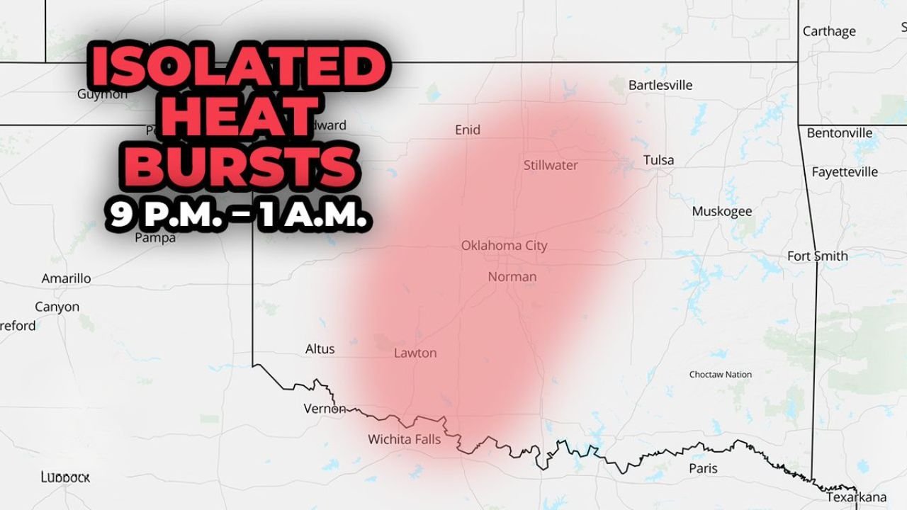
Central Oklahoma Faces Rare Isolated Heat Bursts Tonight Between 9 PM and 1 AM With Sudden Temperature Spikes to 80 Degrees and Wind Gusts of 45 to 55 MPH Possible Near Oklahoma City, Norman, Enid, Stillwater, and Lawton
OKLAHOMA CITY, OKLAHOMA — As if this week’s severe weather pattern has not already delivered enough unusual atmospheric activity across the central United States, central Oklahoma faces a rare and little-understood weather phenomenon tonight — isolated heat bursts between 9 PM and 1 AM on Tuesday, March 31, 2026. Residents near Oklahoma City, Norman, Enid, Stillwater, and Lawton could experience a sudden and jarring spike in temperatures to near 80 degrees around midnight, accompanied by wind gusts of 45 to 55 mph — arriving with little to no warning in one or two communities across the central Oklahoma corridor.
What Is a Heat Burst — and Why Is It So Unusual
A heat burst is one of the rarest and most disorienting weather events that can occur across the Plains — and most people who experience one have no idea what just happened.
Under normal circumstances, temperatures drop steadily after sunset as the surface loses heat to the atmosphere. A heat burst violates that expectation completely — producing a sudden, dramatic, and completely counterintuitive spike in temperature in the middle of the night, often accompanied by strong, dry wind gusts that arrive out of nowhere.
To understand why heat bursts happen, you have to understand what is happening above the surface as thunderstorms weaken.
The Science Behind Tonight’s Heat Burst Threat
When thunderstorms weaken and begin to collapse — particularly storms moving in from the west into a dry sub-cloud layer — a specific and unusual chain of atmospheric events can unfold.
As the storm weakens, pockets of rain-cooled air that were suspended in the middle levels of the atmosphere begin to sink toward the surface. Under normal conditions, this descending air would reach the ground still relatively cool and moist — producing the gentle cooling breeze that often follows a passing thunderstorm.
But when those descending air parcels sink into a dry sub-cloud layer — a zone of very low humidity between the storm and the ground — something different happens. As the rain falls through this dry layer, the moisture evaporates before reaching the surface. Once that evaporative cooling effect is gone, the descending air parcel no longer has the mechanism that was keeping it cool.
The air parcel continues sinking. As it descends, it encounters increasing atmospheric pressure near the surface — and that pressure compresses the air parcel, heating it. This is the same basic process that makes air warm when you compress it — a bicycle pump gets warm at the tip because the air is being rapidly compressed.
The result is a descending pocket of air that arrives at the surface dramatically warmer and drier than the air it is replacing — producing a sudden, localized spike in temperature and a burst of hot, gusty winds that can arrive in a matter of minutes.
What Tonight’s Heat Burst Could Produce
Tonight’s specific heat burst threat across central Oklahoma carries two distinct impacts that residents should be aware of:
Sudden temperature spike to near 80°F around midnight. Residents who go to bed with temperatures in the 60s or 70s could wake up — or be woken up — by temperatures briefly jumping to near 80 degrees in the middle of the night. This is not a gradual warming. Heat bursts produce abrupt and dramatic temperature changes that can occur within minutes as the descending hot air pocket reaches the surface.
Wind gusts of 45 to 55 mph. The same descending air mass that produces the temperature spike also generates strong, gusty surface winds as it spreads outward from the point of impact. Gusts of 45 to 55 mph are capable of downing tree branches, creating hazardous driving conditions, and causing localized damage to property — arriving suddenly in the middle of the night when most residents are asleep and unprepared.
Abrupt drying. The air arriving with a heat burst is not just hot — it is extremely dry. Relative humidity can drop dramatically in the communities directly impacted, creating conditions that are uncomfortable for anyone outdoors and potentially concerning for fire weather if any ignition sources are present.
Where Tonight’s Heat Burst Risk Is Concentrated
The heat burst threat tonight is focused on central Oklahoma — a broad zone centered roughly over the Oklahoma City metro and extending outward to cover Enid to the north, Stillwater to the northeast, Lawton to the southwest, and Norman to the south.
| City | Heat Burst Risk |
|---|---|
| Oklahoma City | In risk zone |
| Norman | In risk zone |
| Stillwater | In risk zone |
| Enid | In risk zone |
| Lawton | In risk zone |
| Tulsa | Eastern fringe |
| Wichita Falls, TX | Southern fringe |
The nature of heat bursts makes precise location prediction nearly impossible. They are highly localized — one community may experience the full force of a heat burst while a town just 10 miles away sees nothing unusual. The map shows the zone of potential, not a guarantee of impact at any specific location.
Timing — 9 PM to 1 AM
The heat burst window tonight runs from 9 PM through 1 AM — directly overlapping with the hours when most residents will be winding down for the night or already asleep.
This timing is significant. Unlike daytime severe weather where residents are alert and active, a midnight heat burst with 50 mph wind gusts arriving while people are asleep creates a different kind of hazard. Residents may not hear falling tree branches, may leave vehicles or outdoor property unsecured, and may have windows open on what started as a comfortable spring evening — only to have hot, gusty air push through suddenly in the middle of the night.
Forecast Confidence Level
Medium confidence on heat burst development tonight — heat bursts are by nature difficult to predict precisely because they depend on the exact behavior of individual weakening thunderstorm cells and the specific depth and dryness of the sub-cloud layer at the moment of storm collapse.
Higher confidence on the geographic focus area** — central Oklahoma from Enid through Oklahoma City and Lawton is where the atmospheric setup is most favorable for heat burst development tonight based on storm positioning and sub-cloud layer characteristics.
Lower confidence on which specific communities will be affected** — heat bursts are highly localized and the difference between a direct hit and no impact can be just a few miles. This is a watch-and-wait situation for specific communities within the broader risk zone.
What Oklahoma Residents Should Do Before Midnight
Secure any outdoor furniture, vehicles, and loose items before going to bed tonight. Wind gusts of 45 to 55 mph arriving around midnight can cause property damage and send lightweight objects airborne without warning. Do not leave anything unsecured that could be damaged or become a hazard in high winds.
Close your windows before going to sleep. A heat burst producing 80-degree air and 50 mph wind gusts pushing through open windows in the middle of the night is disorienting and potentially hazardous. Starting the night with windows closed in the affected zone is a simple precaution.
Do not be alarmed if you wake up to sudden heat and wind. Heat bursts are rare but not dangerous in the way a tornado or flash flood is. If you wake up to suddenly hot, gusty conditions around midnight in central Oklahoma tonight, the likely explanation is a heat burst — not a more serious threat. Stay indoors, away from windows, and wait for conditions to stabilize.
Check for any storm damage in the morning. Even if you sleep through tonight’s heat burst window, check your property for downed branches, damage from wind-blown objects, and any impacts from the gusty conditions before heading out Thursday morning.
The Bottom Line
Central Oklahoma faces a rare isolated heat burst threat tonight between 9 PM and 1 AM — a highly unusual atmospheric phenomenon capable of producing sudden temperature spikes to near 80 degrees around midnight and wind gusts of 45 to 55 mph across communities including Oklahoma City, Norman, Enid, Stillwater, and Lawton. Heat bursts occur when weakening thunderstorms collapse into a dry sub-cloud layer, sending descending air parcels to the surface that arrive dramatically hotter and drier than the air they replace. The phenomenon is rare, localized, and difficult to predict precisely — but the atmospheric setup tonight makes central Oklahoma the most likely location in the country for heat burst development before sunrise. Secure outdoor property, close your windows, and do not be surprised if tonight delivers one of the most unusual weather experiences of the spring season so far.
Stay ahead of rare and dangerous weather events before they arrive. Visit cabarrusweekly.com for daily severe weather coverage, unusual weather phenomenon alerts, and storm updates from across the United States — because knowing early is the difference that matters.