Oklahoma, Kansas, and Central Texas Face Three-Zone Severe Weather Outbreak Wednesday Night April 1 With Egg-Sized Hail, Golf Ball Hail, Squall Line, and Quick-Hitting Tornadoes Targeting the I-35 Corridor Including Oklahoma City
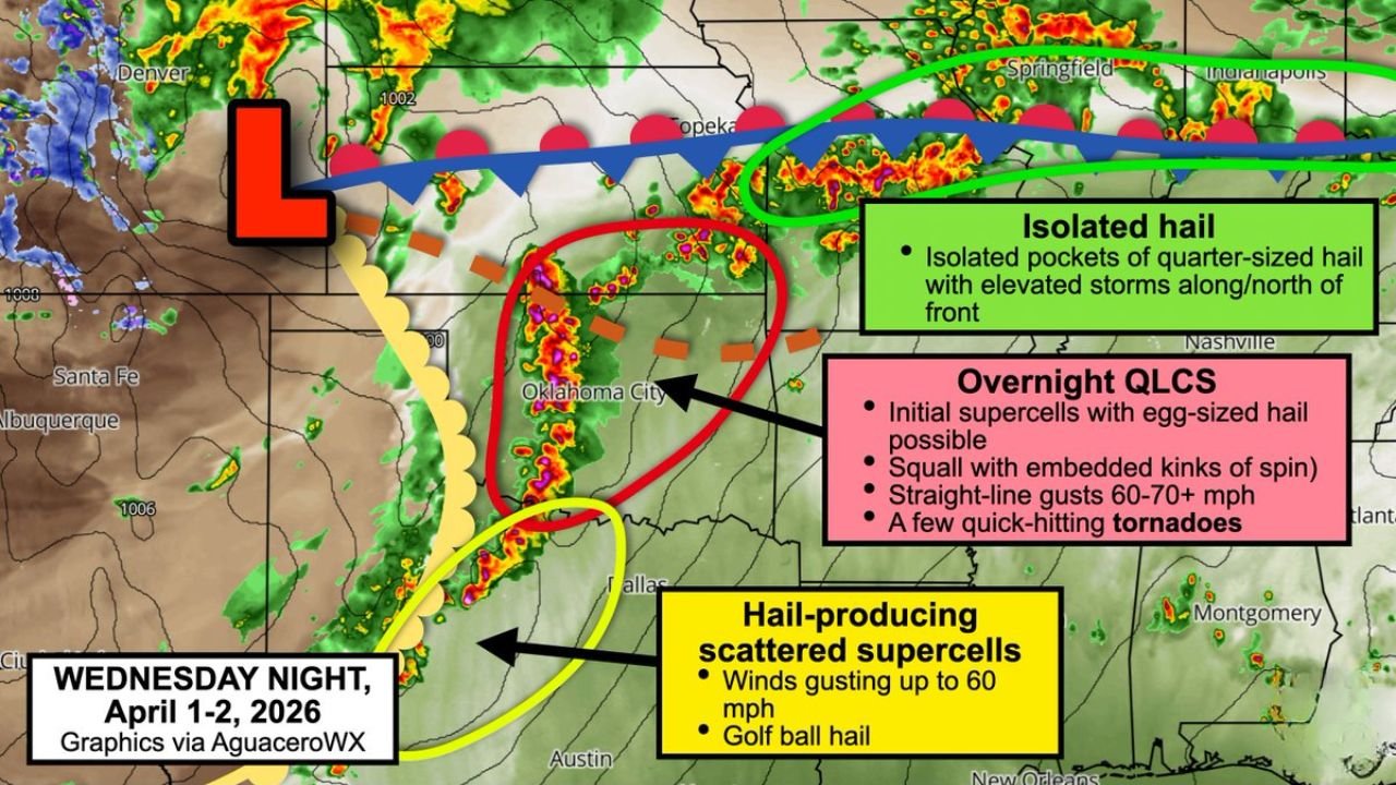
OKLAHOMA CITY, OKLAHOMA — Wednesday, April 1, 2026 is delivering on every forecast concern raised earlier this week. A three-zone severe weather outbreak is unfolding across the southern Plains tonight — with rotating supercells already firing across central Oklahoma and southern Kansas, a separate hail-producing storm complex targeting central Texas, and an isolated hail threat riding along a west-to-east boundary through the Ozarks and Midwest. The most dangerous window arrives tonight as a squall line races eastward toward the I-35 corridor including Oklahoma City — bringing 60 to 70-plus mph straight-line wind gusts and quick-hitting tornadoes with very little warning time.
Zone One — Central Oklahoma and Southern Kansas: The Most Dangerous Zone Tonight
The primary and most dangerous severe weather zone tonight is centered over central Oklahoma and southern and southeast Kansas — where rotating supercell thunderstorms are expected to fire rapidly after 4 PM Wednesday afternoon.
The initial storm mode will be discrete supercells — the most tornado-capable storm structure. During the afternoon hours, these storms will produce egg-sized hail and carry a low-end tornado risk as they develop and organize across the Oklahoma and Kansas corridor. Residents from Topeka southward through Oklahoma City and Norman should be in full severe weather ready mode by early afternoon — not waiting until evening when conditions become more complex.
The setup changes dramatically by 7 PM. As the afternoon heating wanes and the low-level jet begins to accelerate, the individual supercells will start merging into windy lines and clusters — transitioning from discrete rotating storms into a more organized and faster-moving system. This transition is both good news and bad news. The tornado risk from individual supercells decreases as storms merge — but the wind and embedded spin threat becomes significantly more widespread and harder to track.
The Overnight QLCS — Racing Toward I-35 and Oklahoma City
By late evening and into the overnight hours, the storm complex is expected to fully organize into a Quasi-Linear Convective System — a QLCS — a fast-moving squall line with embedded kinks of rotation that races eastward across Oklahoma and into Kansas.
The QLCS is targeting the I-35 corridor — one of the most heavily traveled and populated transportation arteries in the central United States, running directly through Oklahoma City and stretching northward toward Wichita and southward toward Dallas.
Two specific threats come with the overnight QLCS:
Straight-line wind gusts of 60 to 70-plus mph are possible within the squall line as it pushes through. Winds at these speeds are capable of causing widespread tree damage, downing power lines across large areas, and creating dangerous driving conditions along I-35 and surrounding highways. The overnight timing means many residents will be asleep when the squall arrives — with no opportunity to make real-time decisions about shelter.
Quick-hitting brief spinup tornadoes are possible within the embedded kinks of spin inside the squall line. QLCS tornadoes are among the most dangerous types of tornadoes precisely because they are difficult to detect on radar, form rapidly, and often strike with only 1 to 3 minutes of warning time — far less than the 13-minute average warning time for supercell tornadoes. A QLCS tornado can touch down, cause damage, and lift before most residents even process the warning alert on their phones.
Zone One Threat Timeline — Wednesday April 1
| Time | Storm Mode | Primary Threats |
|---|---|---|
| After 4 PM | Discrete rotating supercells | Egg-sized hail, low-end tornado risk |
| By 7 PM | Merging into lines and clusters | Large hail, damaging winds increasing |
| Overnight | QLCS squall line racing east | 60-70+ mph gusts, quick-hitting tornadoes, embedded spin |
| I-35 / Oklahoma City | Direct QLCS target | Straight-line winds, brief spinup tornadoes |
Zone Two — Central Texas: Golf Ball Hail and 60 MPH Gusts
Separate from the Oklahoma and Kansas storm complex, a second and independent severe weather zone is active tonight across central Texas — centered from San Angelo and Barnhart northeastward through Abilene, Aspermont, Seymour, and Quanah.
The storm mode across central Texas tonight is widely scattered supercells — meaning coverage will be more spread out than Zone One, but the individual storms that develop will be capable of significant severe weather impacts.
The headline threat in central Texas tonight is golf ball-sized hail — stones measuring approximately 1.75 inches in diameter — with the strongest supercells. Golf ball hail causes serious damage to vehicles, roofs, windows, and any outdoor equipment or property caught in the open. A single hailstorm passing over a populated area can cause millions of dollars in damage within minutes.
Wind gusts up to 60 mph are also possible with the strongest Texas storm cells tonight — adding a wind damage component to the hail threat across the San Angelo to Quanah corridor.
Zone Three — Ozarks and Midwest: Isolated Quarter-Sized Hail
The third and northernmost zone tonight extends across portions of the Ozarks and Midwest — covering Missouri, southern Illinois, and into Indiana along the Springfield to Indianapolis corridor.
In this zone, elevated storm cells are riding along the west-to-east boundary that stretches across the northern edge of the severe weather complex. These elevated storms — meaning storms with their bases above the surface boundary rather than rooted directly in the warmest surface air — are capable of producing isolated pockets of quarter-sized hail as they track eastward through the night.
The tornado and wind threat in Zone Three is lower than Zones One and Two — but the hail threat is real enough that residents across the Ozarks and central Midwest should remain weather aware through the overnight hours and protect vehicles if possible.
Complete Threat Summary — Wednesday Night April 1-2
| Zone | Location | Threats |
|---|---|---|
| Zone 1 — Red | Central Oklahoma / Southern Kansas / I-35 | Egg-sized hail, QLCS 60-70+ mph gusts, quick-hitting tornadoes, embedded spin |
| Zone 2 — Yellow | Central Texas — San Angelo to Quanah | Golf ball hail, 60 mph wind gusts, scattered supercells |
| Zone 3 — Green | Ozarks / Midwest — Springfield to Indianapolis | Isolated quarter-sized hail, elevated storm cells |
Forecast Confidence Level
High confidence on supercell development after 4 PM across central Oklahoma and southern Kansas — the atmospheric setup is locked in and storms are already initiating.
High confidence on the QLCS transition overnight and eastward push toward I-35 and Oklahoma City** — the timing and storm mode evolution are well-established in forecast data.
High confidence on golf ball hail across central Texas** — the thermodynamic environment across the Zone Two area strongly supports large hail with the strongest supercells.
Medium confidence on exact QLCS tornado tracks** — QLCS tornadoes are inherently difficult to predict in terms of precise location and timing. The threat is real but the specific communities affected cannot be identified in advance with high precision.
What You Must Do Right Now — Before the Squall Arrives
If you are along or near I-35 in Oklahoma tonight — be in your shelter before the squall arrives. Do not wait for the tornado warning to be issued. By the time a QLCS warning reaches your phone, the storm producing it may be only minutes away. Get indoors, get to your lowest interior room, and stay there until the squall has fully passed.
Do not drive through the squall line tonight. Sixty to seventy mph straight-line winds and embedded tornadoes moving at highway speeds along the I-35 corridor create an extraordinarily dangerous driving environment. If you are on the road and a squall line is approaching, exit the highway, find a sturdy building, and shelter inside — not in your vehicle.
Central Texas residents from San Angelo to Quanah should secure vehicles in garages or covered structures before tonight’s storms arrive if at all possible. Golf ball-sized hail causes serious and expensive damage to unprotected vehicles within minutes of storm passage.
Ozarks and Midwest residents — your threat level is lower tonight but not zero. Quarter-sized hail can still cause windshield damage and roof impacts. Keep alerts active through the overnight hours and do not dismiss the threat simply because the higher-risk zones are further south and west.
Set a weather alert on your phone to maximum volume before going to sleep tonight. The overnight QLCS targeting Oklahoma City is the most dangerous element of tonight’s setup precisely because most residents will be asleep when it arrives. A wireless emergency alert is only useful if something wakes you up to receive it.
The Bottom Line
Wednesday night April 1-2 brings a three-zone severe weather outbreak across the southern Plains and Midwest. The most dangerous zone targets central Oklahoma, southern Kansas, and the I-35 corridor including Oklahoma City — where rotating supercells firing after 4 PM transition into a fast-moving QLCS squall line overnight capable of 60 to 70-plus mph straight-line winds and quick-hitting brief tornadoes with minimal warning time. A separate zone across central Texas brings golf ball-sized hail and 60 mph gusts from San Angelo through Abilene and Quanah. The Ozarks and Midwest face isolated quarter-sized hail along an elevated storm boundary. Be sheltered before the squall arrives — do not wait for a warning to act tonight.
Stay ahead of dangerous weather before it reaches your door. Visit cabarrusweekly.com for real-time severe weather coverage, tornado alerts, and storm updates from across the United States — because knowing early is the difference that matters.