Pennsylvania, New Jersey, New York and New England Face Rain-to-Snow Shift as Cold Air Crashes In Behind East Coast Squall Line
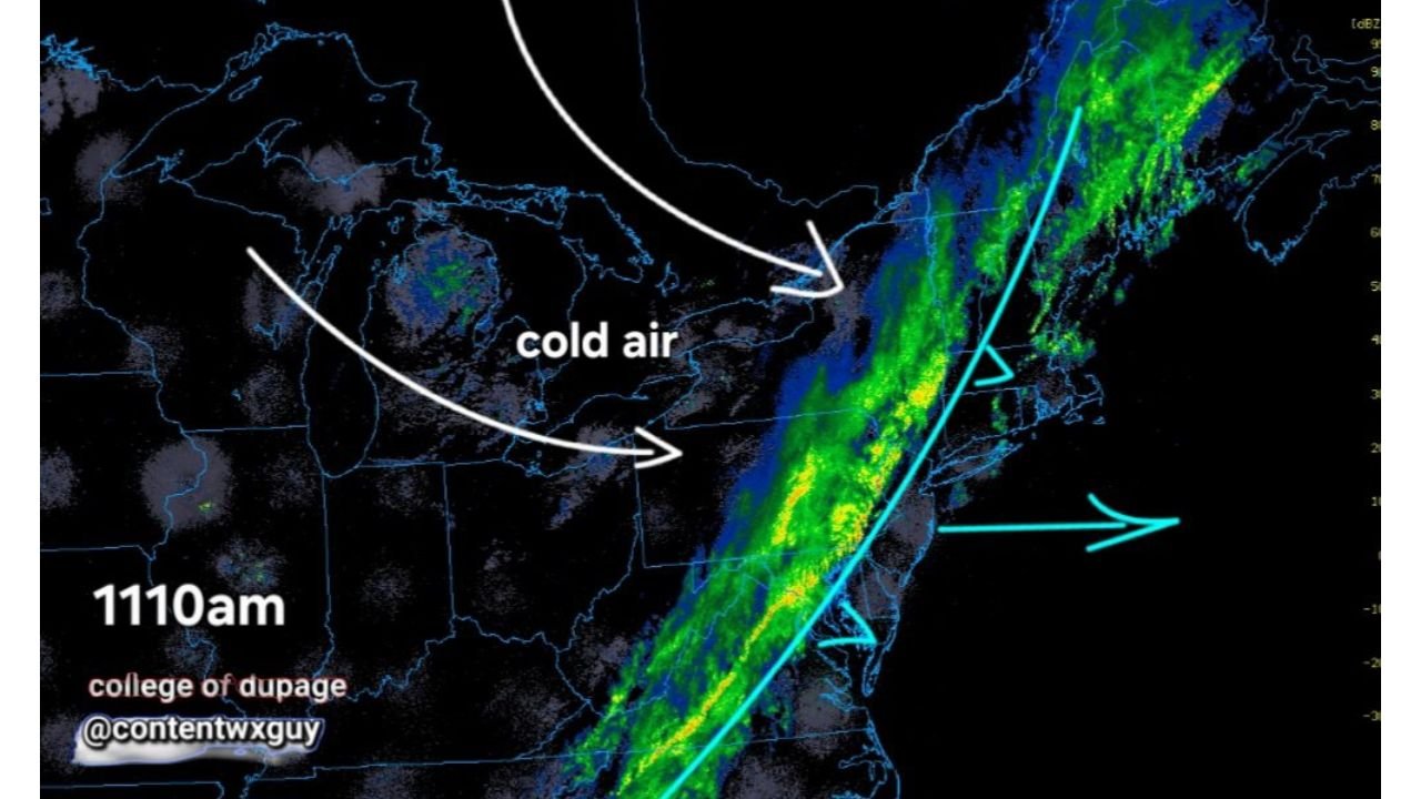
UNITED STATES — A narrow but active squall line of rain and brief downpours is sweeping east across the Mid-Atlantic and Northeast today, marking a sharp transition in the weather pattern as colder air rapidly pushes in behind the system.
This setup is not just a typical rain event — it is the leading edge of a significant temperature drop that will change precipitation type and bring freezing conditions back into play by Tuesday night.
Fast-Moving Rain Band Targets the Northeast Today
The current radar pattern shows a tight line of showers and heavier bursts moving east through:
- Pennsylvania
- Northern New Jersey
- New York
- Extending into New England
Rainfall will generally be brief but occasionally intense, with some locations experiencing quick downpours as the line passes through.
Cold Air Rushes In Immediately Behind the Front
Once the rain exits, conditions will change quickly:
- Cold air will surge in from the west
- Temperatures will drop noticeably within hours
- Winds may increase as the colder air mass settles in
This rapid transition is being driven by an upper-level disturbance, reinforcing the colder pattern across the region.
Tuesday Brings Snow Showers and Squally Bursts
As the colder air deepens, the pattern evolves further:
- Snow showers are expected Tuesday across Pennsylvania, northern New Jersey, New York, and parts of New England
- Some areas could see brief squall-like bursts of snow, reducing visibility for short periods
- Accumulation appears limited, but quick hits of snow could still impact travel temporarily
Widespread Freeze Expected Tuesday Night
The biggest concern following this system is the cold that follows:
- Sub-freezing temperatures are expected across a wide area Tuesday night
- Many locations could dip well below freezing for several hours
- This raises concerns for early-season vegetation and sensitive plants
The cold snap is notable given the recent stretch of milder weather across the region.
A Quick-Hitting but Impactful Pattern Change
This system highlights a classic spring transition:
- Rain and mild air ahead of the front
- Followed by a sharp drop in temperatures
- Ending with snow showers and freezing conditions
Even though precipitation will not be long-lasting, the combination of squalls, wind, and cold air makes this a high-impact short-duration event.
Stay With Cabarrus Weekly for Ongoing Updates
As this fast-moving system continues across the Northeast and colder air settles in, stay connected with Cabarrus Weekly for the latest updates on temperature drops, snow chances, and freeze alerts across the United States.