Texas, Oklahoma, Arkansas, Missouri, Illinois, Indiana and Michigan Under Expanding Tuesday Severe Storm Threat With Tornadoes, Supercells and Possible Upgrade Ahead
UNITED STATES — A widespread and potentially significant severe weather outbreak is expected to develop Tuesday, stretching from the Southern Plains through the Mississippi Valley and into the Great Lakes region.
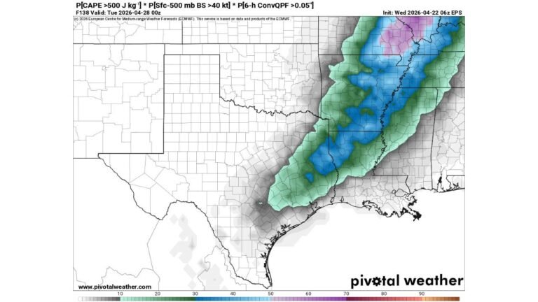
Massive Storm Corridor Expands From Southern Plains to Great Lakes
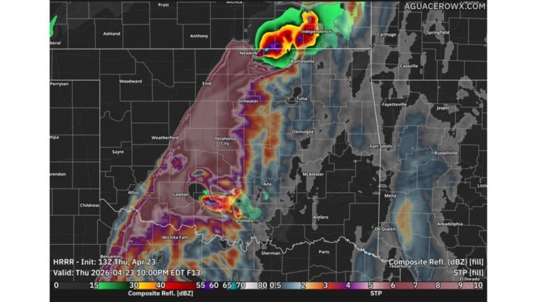
Forecast data shows a broad severe weather zone extending from Texas and Oklahoma through Arkansas, Missouri, Illinois, Indiana, and into Michigan. This large footprint highlights the scale of the system, covering multiple regions simultaneously.
The Storm Prediction Center has already outlined a 15% severe weather probability, indicating organized storm development across this entire corridor.
Supercells and All Severe Hazards Possible
Atmospheric conditions appear favorable for supercell thunderstorm development, which are capable of producing the most dangerous types of severe weather.
Across this region, all hazards are possible, including:
damaging winds, large hail, and tornadoes. The setup supports storms that could become intense quickly, especially during the afternoon and evening hours.
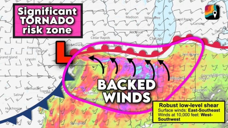
Tornado Risk Emerging Across Central Corridor
One of the key concerns within this setup is the potential for tornado development, particularly across the central portion of the risk area, including parts of Missouri, Illinois, and Indiana.
With strong storm organization expected, rotating storms could develop within the broader system, increasing the likelihood of isolated tornadoes embedded within larger storm clusters.
Conditions May Support a Stronger Severe Weather Event
Early indications suggest this system could evolve into a more substantial severe weather event, especially as it moves into the Midwest.
The combination of moisture, instability, and wind energy across the region may allow storms to become more widespread and more intense, raising concerns for larger impacted areas.
There is also potential for an upgrade in the risk level as the event approaches, depending on how atmospheric conditions continue to develop.
Timing and Impact Areas to Watch
The most active period is expected during Tuesday afternoon through late evening, when storm coverage and intensity are likely to peak across the region.
Areas from the Southern Plains into the Mississippi Valley and Great Lakes should closely monitor forecasts, as storms may develop quickly and move across state lines over a short period of time.
Given the size of the risk area, millions of people could be impacted, with severe storms affecting both rural and urban regions.
What This Means Going Forward
This setup represents one of the more expansive severe weather threats in recent days, with a large geographic footprint and multiple hazards expected at once.
The possibility of stronger storms and a risk upgrade makes this a situation that requires close attention as Tuesday approaches.
Stay with CabarrusWeekly.com for the latest updates, and share what conditions you are seeing in your area as this severe weather system develops.