Conditional Severe Weather Threat Targets Texas Oklahoma And Kansas Sunday As Main Trough Remains Out West With Large Hail Damaging Winds And Isolated Tornadoes Possible Along Dryline Late Afternoon
UNITED STATES — A conditional severe weather threat exists across parts of the Plains on Sunday, April 12, 2026, with the primary risk area focused across Texas, Oklahoma, and Kansas as atmospheric conditions set the stage for potential storm development along a dryline during the late afternoon and early evening hours.
Main Trough Still Well Out West, Limiting Severe Threat Sunday
The setup for Sunday’s potential severe weather comes with significant uncertainty. The main trough that will provide a more robust and widespread severe threat on Monday and Tuesday remains well back to the west, while a lead shortwave is advancing eastward across the Plains.
This positioning is critical — the primary risk area on Sunday is sandwiched between these two atmospheric waves, creating a narrow and conditional window for storm development.
According to forecast data, sinking air (subsidence) will likely overrule much of the warm sector, suppressing storm development behind earlier activity during the day. With meager forcing (ascent for thunderstorms) around the dryline, storms may struggle to initiate — potentially resulting in no severe threat at all for parts of the region.
Isolated Storms Possible Along Dryline Late Afternoon Into Evening
Despite the overall suppressive environment, forecasters note that subtle forcing mechanisms could trigger at least a couple of isolated storms along the dryline during the late afternoon to early evening hours across TX/OK/KS.
If these storms manage to develop and mature, the primary hazard will be large hail, though damaging winds and a couple of tornadoes will also be possible.
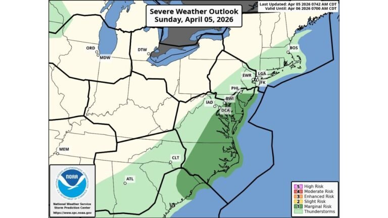
The NOAA Storm Prediction Center’s Severe Weather Outlook for Sunday, April 12, 2026 — valid until April 13, 2026 at 7:00 AM CDT — highlights the following risk levels:
- Slight Risk (Level 2) — across portions of Texas and Oklahoma, where the highest storm potential exists
- Marginal Risk (Level 1) — extending northward through Kansas and into the Midwest corridor
- General Thunderstorm Risk — covering a broader area from the Plains into the Great Lakes region
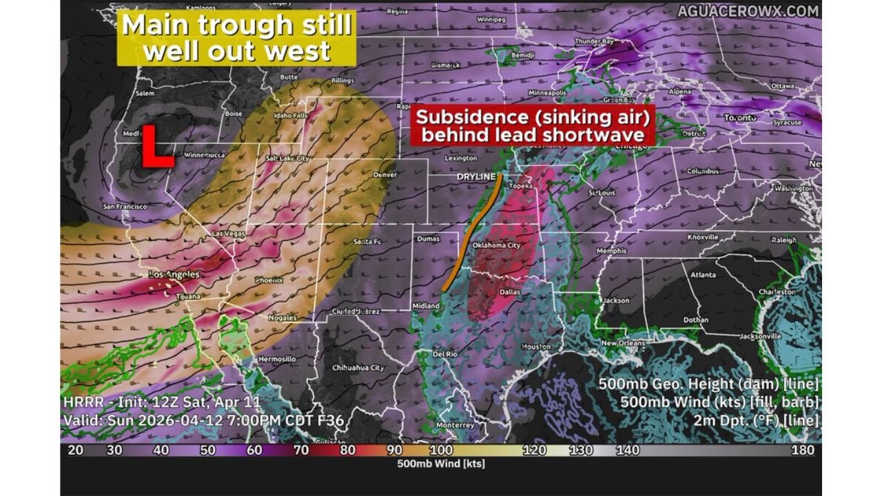
What The Atmosphere Looks Like Sunday: HRRR Model Data
High-resolution forecast model data (HRRR, initialized 12Z Saturday, April 11, valid Sunday April 12 at 7:00 PM CDT) paints a clear picture of the challenges forecasters face:
- The main low-pressure system (trough) remains anchored well out west, limiting the overall energy available for storm development across the Plains
- Subsidence (sinking air) is clearly evident behind the lead shortwave, acting as a cap that suppresses thunderstorm activity across much of the warm sector
- The dryline is positioned through central Oklahoma and into north Texas, near the Dallas and Oklahoma City corridor — this boundary remains the focal point for any storm initiation Sunday
This setup means storm chances are conditional and highly dependent on whether subtle forcing mechanisms can overcome the sinking air across the region.
Primary Hazards If Storms Develop
Should isolated storms manage to fire along the dryline during the late afternoon and evening hours, residents across TX/OK/KS should be aware of the following threats:
- Large Hail — the primary and most likely hazard with any supercell development
- Damaging Winds — possible with stronger storm cells
- Isolated Tornadoes — a couple cannot be ruled out if storms become organized
Eyes Turn To Monday And Tuesday For More Significant Threat
While Sunday’s severe weather potential remains conditional and limited, the more significant and widespread severe weather event is expected Monday and Tuesday as the main trough currently sitting out west finally pushes eastward into the Plains and central United States.
Residents across the Southern Plains, Midwest, and Great Lakes regions should monitor forecasts closely heading into the early week as atmospheric energy increases significantly with the arrival of the primary system.
What Residents Should Do Now
For those living across Texas, Oklahoma, and Kansas, here is what to keep in mind heading into Sunday:
- Stay weather-aware throughout the afternoon and evening hours
- Have a severe weather plan in place in case storms develop quickly
- Monitor local National Weather Service forecasts for the latest updates
- Understand that storm chances remain conditional — storms may not develop at all, but preparation is still advised
For continued updates on severe weather threats, storm outlooks, and regional weather impacts, stay with CabarrusWeekly.com as this developing weather pattern continues to evolve through the remainder of the weekend and into next week.