3 to 5 Inches of Weekend Rain Brings a Much-Needed Soil Moisture Boost to the Central Plains — But the Maps Show How Much Work Is Still Left to Do Across Nebraska, Kansas, and Beyond
CENTRAL PLAINS, UNITED STATES — A significant rainfall event over the weekend delivered 3 to 5 inches of heavy rain across portions of the Central Plains, and the updated soil moisture data is already reflecting that improvement. But while the rain brought welcome relief to some areas heading into planting season, the broader soil moisture picture across Nebraska, Kansas, and surrounding states tells a story that one weekend of rain cannot fully fix.
The Weekend Rain That Made a Difference
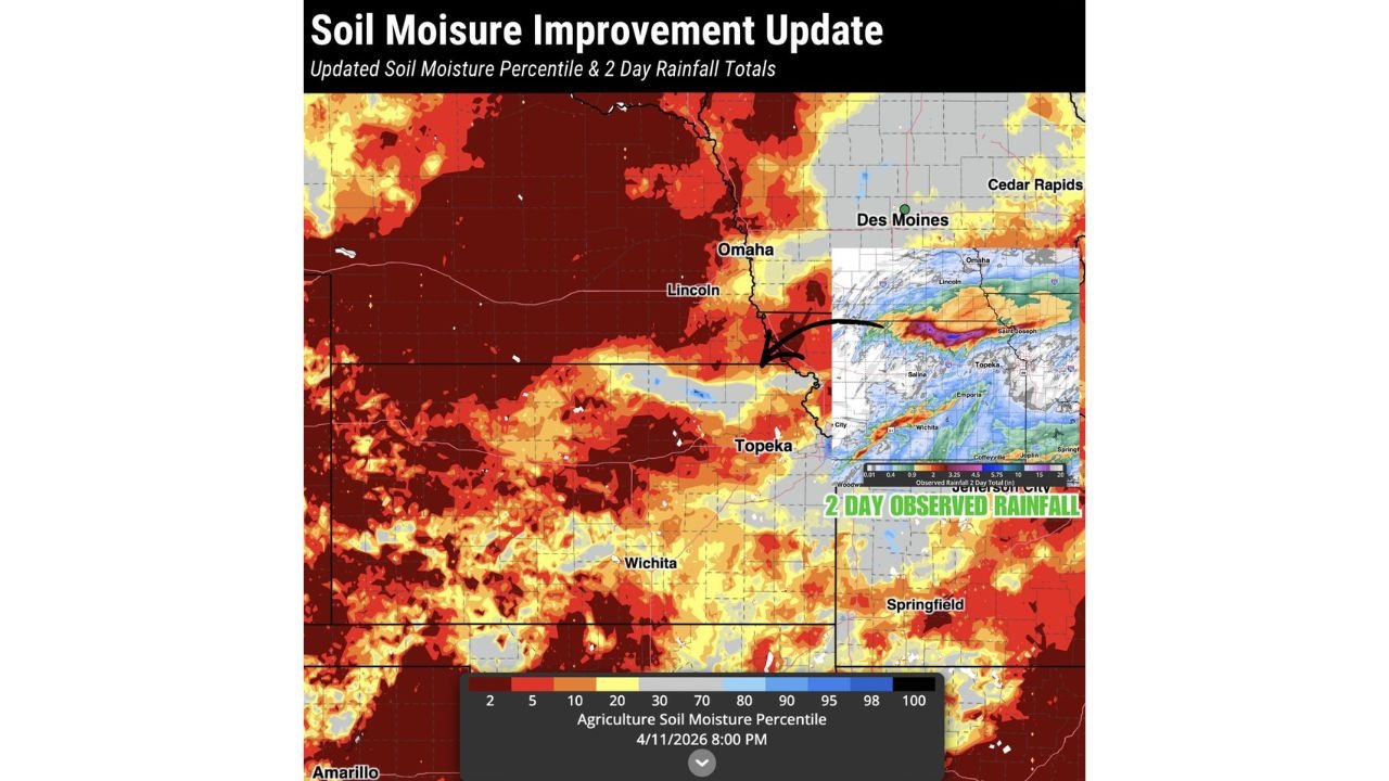
Heavy rainfall totaling 3 to 5 inches fell across the Central Plains this weekend, delivering the kind of soaking event that drought-stressed soils desperately needed heading into the critical planting season. The impact was immediate and measurable — the updated Agriculture Soil Moisture Percentile map, valid April 11, 2026 at 8:00 PM, shows the improvement clearly in the areas where the heaviest rain fell.
The 2-day observed rainfall inset on the updated map pinpoints where the rain made its biggest impact. The heaviest totals fell across a corridor covering portions of Kansas and Missouri, with the bull’s-eye of rainfall centered around the Saint Joseph, Topeka, Wichita, Salina, and Emporia areas extending toward Joplin and Springfield to the east. Rainfall amounts in the deepest purple shading on the observed map indicate the highest totals of the event, with lighter blues and greens filling in the surrounding areas.
What the Updated Soil Moisture Map Shows
The soil moisture improvement is visible — but so is the scale of the problem that remains. The updated Agriculture Soil Moisture Percentile map tells a nuanced story across the region.
| Area | Soil Moisture Percentile | Condition |
|---|---|---|
| Eastern Nebraska near Omaha and Lincoln | 20 to 30 percentile | Improving but still dry |
| Topeka and northeast Kansas | 20 to 30 percentile | Showing weekend improvement |
| Wichita and central Kansas | 5 to 20 percentile | Still significantly dry |
| Western Nebraska | 2 to 5 percentile | Severe to extreme dryness |
| Southwest Kansas near Amarillo corridor | 2 to 5 percentile | Severe to extreme dryness |
| Des Moines and Cedar Rapids, Iowa | 5 to 20 percentile | Moderate to severe dryness |
| Springfield, Missouri area | 20 to 30 percentile | Moderate improvement |
The contrast is stark. Areas that received the heaviest weekend rainfall — particularly around Topeka, Saint Joseph, and the Kansas-Missouri border region — show measurable improvement in the yellow and light orange range. But vast stretches of western Nebraska, southwest Kansas, and the areas around Amarillo remain locked in the darkest red and maroon shading, indicating soil moisture percentiles at 2 to 5 — among the lowest recorded conditions compared to historical norms going back decades.
Good News for Planting Season — But Only in the Right Spots
The timing of this rainfall could not be more important. Soil moisture maps will continue to be critical throughout planting season, and farmers across the Central Plains are watching these updates closely as they prepare fields and make planting decisions.
For producers in the areas that received the heaviest 3 to 5 inch totals — particularly across northeast Kansas, the Kansas City corridor, and areas toward Joplin and Springfield — this weekend’s event provided a genuine and meaningful boost to soil moisture at a pivotal time. Fields in those areas will enter the week in considerably better shape than they were heading into the weekend.
However, for farmers across western Nebraska, southwest Kansas, and the broader drought core still showing deep red on the soil moisture map, the weekend rain was largely a miss. Those areas remain in severe to extreme drought with soils that are critically low on moisture as planting season accelerates.
The Drought Core Remains Deeply Entrenched
Despite the weekend improvement in isolated areas, the overall soil moisture map for the Central Plains as of April 11, 2026 remains dominated by drought. The deep red and dark maroon colors covering western Nebraska, western Kansas, and extending toward Amarillo represent some of the most severe soil moisture deficits on the map.
Omaha and Lincoln in Nebraska sit on the edge of the improvement zone, with soil moisture percentiles reflecting partial benefit from the weekend event but still well below normal. Des Moines and Cedar Rapids in Iowa remain in moderately dry territory, with soils that need additional rainfall events to recover meaningfully ahead of the heart of planting season.
The weekend rain was a positive step — but a single 3 to 5 inch event cannot erase what has been a prolonged and widespread drought across the Central Plains. The drought core across western Nebraska and Kansas remains largely intact and will require multiple additional significant rainfall events to bring soil moisture back toward normal levels.
Why Soil Moisture Matters So Much Right Now
As planting season advances across the Central Plains, the condition of soils from the surface down through the root zone will directly determine how crops establish and perform through the spring and early summer.
Low soil moisture at planting means seeds germinate into dry, stressed conditions. It means shallow root development. It means crops that are vulnerable from the very start of the growing season. For farmers already dealing with drought, getting adequate soil moisture before and during planting is not just helpful — it is essential.
The updated maps will continue to be one of the most important tools for agricultural planning across Nebraska, Kansas, Iowa, Missouri, and surrounding states through the weeks ahead.
Central Plains Soil Moisture Snapshot — April 11, 2026
| Factor | Details |
|---|---|
| Weekend rainfall total | 3 to 5 inches across Central Plains |
| Heaviest rain corridor | Saint Joseph, Topeka, Salina, Emporia, Wichita toward Joplin and Springfield |
| Greatest soil moisture improvement | Northeast Kansas and Kansas-Missouri border |
| Remaining drought core | Western Nebraska, western Kansas, Amarillo corridor |
| Soil moisture percentile — drought core | 2 to 5 — severe to extreme |
| Soil moisture percentile — improved areas | 20 to 30 — still below normal but recovering |
| Season context | Critical planting season underway |
One Good Weekend Is a Start — Not a Solution
The heavy rain that fell across the Central Plains this weekend delivered a measurable and welcome improvement to soil moisture across portions of Kansas, Missouri, and eastern Nebraska right as planting season ramps up. The updated maps confirm that the signal is real and that farmers in the best-hit areas have something to work with.
But the maps also confirm that the drought across the broader Central Plains is far from over. The deep red covering western Nebraska, western and central Kansas, and extending toward Amarillo tells the story clearly — one significant rainfall event helps, but the soil moisture deficit built up over months of drought will take sustained, repeated rainfall to truly repair.
Soil moisture maps will remain one of the most critical tools to watch as planting season progresses across the region in the weeks ahead.
Stay with CabarrusWeekly.com for ongoing drought and soil moisture coverage, planting season updates, and the latest rainfall forecasts across the Central Plains.