Illinois, Indiana, Michigan and Ohio Face Saturday Severe Weather Risk as Storm Threat Shifts Toward Great Lakes Cities
UNITED STATES — The active severe weather pattern across the central U.S. is set to continue into the weekend, with Saturday bringing a renewed threat across the Great Lakes region, impacting millions from Illinois and Indiana into Michigan and Ohio.
Saturday Storm Threat Expands Into the Great Lakes
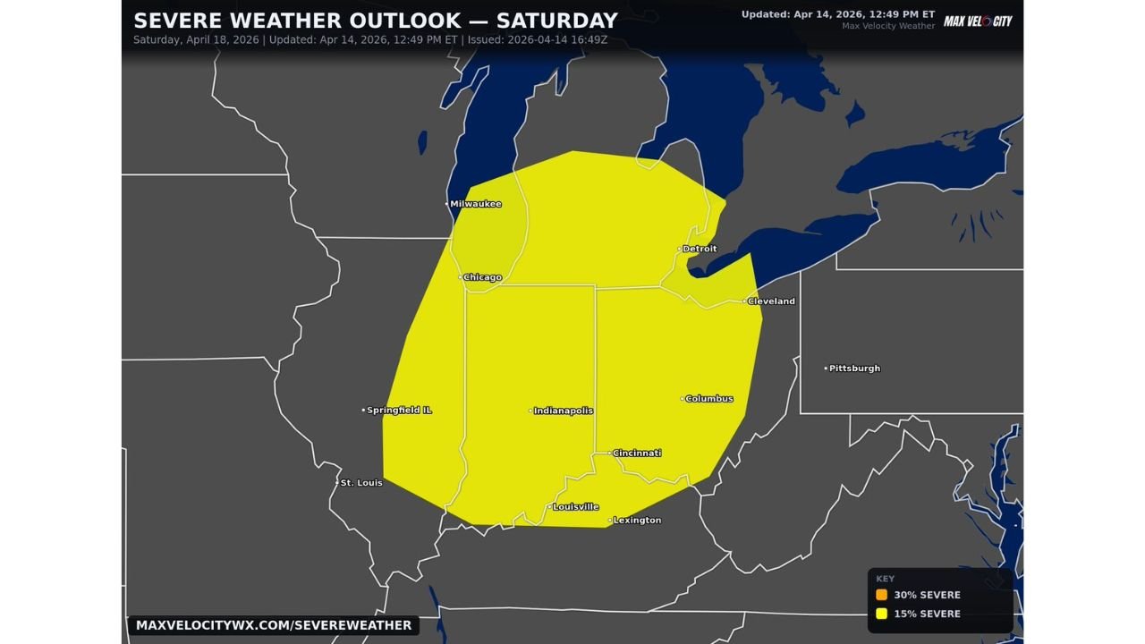
After multiple days of storms across the Plains and Midwest, the focus will shift eastward on Saturday. A 15% severe weather risk zone is already in place, covering a broad area that includes:
- Illinois
- Indiana
- Michigan
- Ohio
Major metro areas in the path include Chicago, Indianapolis, Detroit, Cleveland, and Cincinnati, all of which could see thunderstorms develop as the system progresses.
What the 15% Risk Means for Residents
A 15% severe weather risk indicates a scattered but meaningful threat of severe storms, where multiple storms across the region could become strong.
The primary hazards expected include:
- Damaging wind gusts, capable of causing power outages and tree damage
- Large hail, especially in stronger storm cores
- A few tornadoes, though not expected to be widespread
This type of setup often produces clusters of storms or embedded severe cells, meaning impacts may vary from city to city but still carry significant risk across the region.
Timing and Storm Development
Storms are expected to develop and intensify during the afternoon and evening hours, following daytime heating and increasing atmospheric instability.
As the system shifts east, areas from western Illinois early in the day could see storms first, with activity progressing toward Indiana, Michigan, and Ohio by evening.
Cities like Indianapolis and Cincinnati may see peak impacts later in the day, while Detroit and Cleveland could be impacted as storms push deeper into the Great Lakes.
Continued Active Pattern Through the Weekend
Saturday’s setup is part of a larger, ongoing severe weather pattern that has been impacting the Plains and Midwest over several days. Rather than ending, the threat is simply shifting geographically, bringing new areas into focus.
The continuation of this pattern means:
- Repeated rounds of storms are possible
- Ground conditions may already be sensitive in some areas
- Residents should stay alert for rapidly changing forecasts
What Residents Should Watch Closely
People across the Great Lakes region should monitor:
- Local weather alerts and warnings throughout Saturday
- Rapid storm intensification during peak afternoon hours
- Changing storm tracks that could shift impacts between cities
Even if storms appear scattered, any individual storm could quickly become severe, especially with favorable atmospheric conditions in place.
Bottom Line
Saturday will not be a quiet day for the Midwest and Great Lakes. With Chicago, Indianapolis, Detroit, Cleveland, and Cincinnati all in the risk zone, the region is bracing for another round of damaging winds, large hail, and isolated tornado potential as the storm system pushes east.
Stay with CabarrusWeekly.com for continued updates as this evolving severe weather pattern moves across the eastern half of the country.