Wisconsin, Illinois and Iowa Hit by Overnight Flash Flooding as Training Storms Dump Over 3 Inches Near Madison, Milwaukee and Chicago
WISCONSIN — A significant overnight storm system brought locally heavy rainfall and flash flooding concerns across parts of Wisconsin, northern Illinois, and eastern Iowa, with some areas seeing rainfall totals exceeding 3 inches in just a few hours.
Training Storms Trigger Flash Flood Warnings Across Southern Wisconsin
The heaviest rainfall was concentrated across southern Wisconsin, where repeated rounds of thunderstorms moved over the same locations — a phenomenon known as training storms.
This setup led to:
- Flash flood warnings being issued across multiple counties
- Rapid accumulation of rainfall in a short period
- Increased risk of water-covered roads and localized flooding
Cities including Madison, Milwaukee, and areas toward West Bend were among the hardest hit, with radar estimates indicating bands of intense rainfall pushing through overnight.
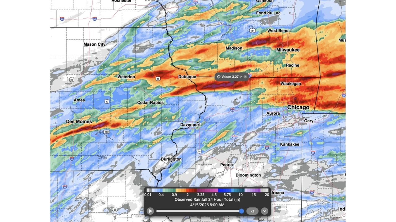
Rainfall Totals Surged Across a Narrow Corridor
Observed rainfall data shows a concentrated band of heavy precipitation stretching from:
- Des Moines, Iowa → Cedar Rapids → Dubuque → Madison → Milwaukee → Chicago
Within this corridor, rainfall totals reached:
- 2 to 3+ inches in many locations
- Locally higher amounts where storms repeatedly tracked
One highlighted zone near Dubuque and Madison recorded values around 3.27 inches, with surrounding areas also seeing significant totals.
Northern Illinois and Chicago Area Also Impacted
The heavy rain band extended into northern Illinois, including the Chicago metro area, where periods of moderate to heavy rain moved through overnight.
While totals in Chicago were slightly lower compared to Wisconsin’s hardest-hit areas, the region still experienced:
- Steady rainfall contributing to ponding on roads
- Reduced visibility during overnight travel
- Potential for minor localized flooding in low-lying areas
Why These Storms Produced So Much Rain
The primary driver behind the heavy rainfall was the slow-moving, repetitive nature of the storm line, which allowed storms to:
- Continuously move over the same areas
- Dump large amounts of rain without shifting quickly
- Intensify rainfall totals in narrow zones
This type of setup is particularly dangerous because it can quickly overwhelm drainage systems, even if storms are not severe in terms of wind or hail.
Conditions Improving, But Impacts May Linger
While the heaviest rain has moved out, lingering impacts may include:
- Standing water on roads during the morning commute
- Elevated creek and stream levels
- Muddy or saturated ground conditions
Residents in affected areas are advised to remain cautious, especially in regions that received the highest rainfall totals.
Bottom Line
Overnight storms delivered a powerful burst of rainfall across Iowa, Wisconsin, and northern Illinois, with southern Wisconsin taking the hardest hit due to training thunderstorms and flash flood warnings. With totals exceeding 3 inches in spots, the event highlights how quickly flooding can develop when storms repeatedly track over the same area.
Stay with CabarrusWeekly.com for continued coverage as additional weather systems move through the Midwest this week.