Summer Heat This Week Then a Stunning Reversal: Baltimore Faces a Sharp Temperature Crash Into the 50s Next Week With a Possible Late-Season Frost or Freeze as April Ends With a Cold Surprise
BALTIMORE, MARYLAND — Baltimore is living through two completely opposite weather chapters in the span of just one week. This week brings summer-like heat that has already been pushing temperatures toward record territory — but the atmosphere is already sending clear signals that a significant cooldown is coming. High temperatures are expected to drop into the 50s or low 60s for several days next week, and forecasters are raising the possibility of one more frost or freeze before April closes out. The pattern flip is real, it is incoming, and it is dramatic.
The Large-Scale Pattern Signals Driving the Cooldown
Three specific atmospheric pattern signals are aligning simultaneously to drive Baltimore’s late-April temperature reversal — and forecasters are naming all three directly.
| Pattern Signal | What It Means for Baltimore |
|---|---|
| Negative AO — Arctic Oscillation | The polar vortex weakens and allows cold air from the Arctic to push south into the mid-latitudes — a classic driver of late-season cold outbreaks across the eastern United States |
| MJO Phase 1 — Madden-Julian Oscillation | The global tropical weather wave is in a phase associated with suppressed convection and enhanced cold air delivery to the eastern U.S. during spring |
| Positive PNA — Pacific North American Pattern | A high-pressure ridge over the Pacific Northwest and trough over the eastern U.S. — a configuration that channels cold Arctic air into the mid-Atlantic and Northeast |
All three of these signals — negative AO, MJO Phase 1, and positive PNA — are pointing in the same direction at the same time. When the atmospheric alphabet lines up like this, it is not a subtle or uncertain signal. It is a well-recognized combination that reliably delivers cold air to the eastern United States, and forecasters are taking it seriously enough to flag the possibility of frost and freeze conditions for Baltimore in late April.
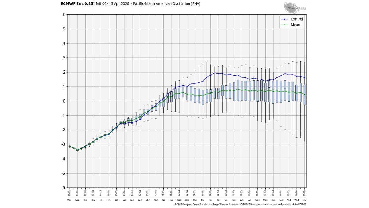
The PNA Trend — From Deeply Negative to Strongly Positive
The Pacific-North American Oscillation chart, initialized 00z April 15, 2026, tells the story of this pattern transition with precision. The PNA index starts the chart period at approximately -3.0 — a deeply negative value associated with warm, zonal flow and the summer-like heat Baltimore is experiencing this week. From that deeply negative starting point, the index rises steadily and crosses into positive territory around April 20-21, eventually reaching values near +1.5 to +2.0 in the control run — a solidly positive PNA configuration that supports cold air delivery to the eastern U.S.
| Date | PNA Value | Baltimore Weather Implication |
|---|---|---|
| April 15-16 | Approximately -3.0 | Summer-like heat in place — warmest stretch of the year |
| April 17-18 | Rising from -2.5 toward -1.5 | Still warm but the pattern beginning to shift |
| April 19-20 | Approaching zero | Transition — cooling trend beginning |
| April 21-22 | Crossing into positive territory | Active cooldown underway |
| April 23-30 | Holding at +1.0 to +2.0 | Cold pattern locked in — 50s and low 60s for Baltimore |
The transition from -3.0 to +2.0 across a roughly 10-day period represents one of the most dramatic PNA index swings possible in the short-to-medium range forecast — and it directly maps to Baltimore’s weather going from near 90 degrees this week to the 50s next week.
What Baltimore Should Expect Day by Day
| Period | Expected Temperature Range | Conditions |
|---|---|---|
| This week — peak heat | Upper 80s to near 90°F | Summer-like, record-challenging heat |
| This weekend | Beginning to moderate | Pattern transition underway |
| Next week — early | Dropping into 60s | Noticeably cooler — jacket weather returns |
| Next week — mid to late | Highs in the 50s to low 60s | Significantly below normal for late April |
| Late April close | Frost or freeze possible | One more cold night potentially on the way |
The normal high temperature for Baltimore in late April runs in the mid to upper 60s. Highs dropping into the 50s would place temperatures 10 to 15 degrees below normal — the opposite extreme from the 20+ degrees above normal heat that is occurring right now this week.
A Frost or Freeze in Late April — How Realistic Is This?
Forecasters are specifically flagging the possibility of one more frost or freeze before April ends — and given the pattern signals in place, it is a realistic and credible threat that Baltimore and the surrounding mid-Atlantic region should take seriously.
A frost occurs when surface temperatures drop to 32-36 degrees Fahrenheit with light winds and clear skies, allowing cold to settle at ground level even when official temperatures remain slightly above freezing. A freeze occurs when official temperatures drop to 32 degrees or below.
For context, Baltimore’s average last frost date is typically in mid-April — meaning a late-April frost, while not unheard of, would arrive after the typical frost-free period has begun. For gardeners, landscapers, and anyone who has already planted tender vegetation or spring flowers in response to this week’s summer warmth, a late-April frost or freeze would be a damaging and potentially destructive development.
The combination of negative AO, MJO Phase 1, and positive PNA makes this late-season cold threat credible enough that forecasters are raising it now while there is still time to prepare.
What This Means for Gardeners and Outdoor Plans
The whiplash from near-90 degree summer heat this week to potential frost conditions next week is one of the most dramatic April pattern reversals Baltimore has seen in recent memory — and it carries real consequences for anyone who acted on this week’s warmth.
- Do not plant frost-sensitive vegetation or annuals this week based on the current summer warmth — a frost or freeze next week could kill tender plants that are not cold-hardy
- Protect any plants already in the ground that cannot tolerate near-freezing temperatures — be ready to cover them or bring them inside when the cold arrives next week
- Garden centers and nurseries should be aware that customers may need frost cloth and cold protection materials as the pattern flips
- Anyone planning outdoor events for next weekend should plan for conditions that feel nothing like this week — 50-degree highs and potentially cold nights rather than summer warmth
Baltimore’s April Pattern Reversal at a Glance
| Factor | Details |
|---|---|
| Chart initialized | 00z April 15, 2026 |
| Pattern signals | Negative AO, MJO Phase 1, Positive PNA |
| Current conditions | Summer-like heat — near 90°F |
| Next week high temperatures | 50s to low 60s — 10 to 15 degrees below normal |
| Late April additional threat | Possible frost or freeze |
| PNA trend | From -3.0 now to +1.5 to +2.0 next week |
| Pattern transition timing | Around April 20-21 |
Summer This Week, Frost Next Week — Baltimore’s Wild April Finale
Baltimore is experiencing one of the most dramatic single-month temperature swings in recent memory. Near-90 degree summer heat this week giving way to 50-degree highs and a possible frost or freeze next week — all within the same month of April. The atmospheric pattern signals driving this reversal are clear, aligned, and already showing in the forecast data.
The summer feel of this week is temporary. The cooldown is coming, it is significant, and it may bring one final cold punch before spring fully establishes itself across the Baltimore and mid-Atlantic region. Stay tuned as the pattern continues to evolve.
Stay with CabarrusWeekly.com for daily Baltimore temperature updates, frost and freeze alerts for late April, and the latest pattern analysis as the dramatic April reversal unfolds across the mid-Atlantic region.