Is Friday Already Shaping Up as the Next Big Severe Weather Day? A Crashing Cold Front and a Loaded Dryline Are Targeting the Plains and Midwest — and Both Can Produce Tornadoes
PLAINS AND MIDWEST, UNITED STATES — The week’s outbreak is barely behind us and Friday April 17, 2026 is already emerging as the next significant severe weather threat across the Plains and Midwest. Two separate and distinct storm regimes are setting up simultaneously — a fast-moving crashing cold front sweeping through the northern corridor, and a sharp dryline developing across Kansas, Oklahoma, and Texas to the south. Both regimes are capable of producing all severe hazards including tornadoes, and the SPC has already placed a Moderate Risk — Level 4 of 5 over the core threat area. The active pattern is not resting.
Two Separate Storm Regimes — Both Dangerous on Friday
What makes Friday’s setup particularly complex — and potentially more dangerous — is the simultaneous operation of two completely independent severe weather regimes across different portions of the Plains and Midwest. Each regime has its own storm type, its own trigger mechanism, and its own hazard profile. Together they create a broad and multi-faceted outbreak threat.
Regime 1 — The Crashing Cold Front Storms will likely develop along a fast-moving crashing cold front sweeping through the northern corridor of the threat zone. Cold front-driven storms are capable of producing all severe hazards including a few tornadoes directly along the frontal boundary. Additionally, storms forming ahead of the cold front line may also develop, capable of producing large hail and tornadoes in the pre-frontal environment where instability is highest.
Regime 2 — The Southern Plains Dryline Further south across Kansas, Oklahoma, and Texas, a sharp dryline may develop — hosting a conditional threat for all significant severe hazards including strong tornadoes if storms can develop along it. The critical uncertainty with the dryline regime is the timing of the cold front — crashing cold fronts can sometimes move faster than medium-range guidance suggests, and if the front overtakes the dryline before storms can organize, the severe and tornado threat associated with the dryline would be significantly reduced.
Friday’s Risk Zones — Already Upgraded to Moderate Risk
The SPC Severe Weather Outlook for Friday April 17, 2026, last updated April 15, 2026 at 2:28 AM CDT and valid until April 18, 2026 at 7:00 AM CDT, shows a well-defined and already elevated risk structure across the central United States.
| Risk Level | Area Covered |
|---|---|
| Moderate Risk — Level 4/5 | Core of Illinois and Missouri — the highest danger zone |
| Enhanced Risk — Level 3/5 | Surrounding zone covering broader Illinois, Missouri, and adjacent states |
| Slight Risk — Level 2/5 | Wider corridor from the southern Plains through the Great Lakes |
| Marginal Risk — Level 1/5 | Outer edges including parts of the Northeast and Southeast |
A Moderate Risk — Level 4 of 5 on a Day 3 outlook is an extraordinary and rare signal. The SPC issues Moderate Risk designations only when confidence is high that a significant and widespread severe weather outbreak is likely. Seeing that level at three days out reflects genuine forecaster confidence in Friday’s threat — and it leaves room for further upgrades as confidence increases and higher-resolution guidance becomes available.
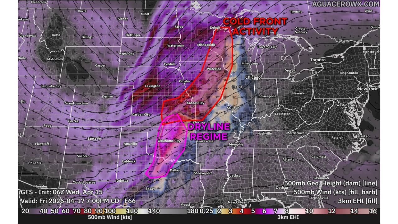
Where the Two Regimes Set Up — The Friday Storm Map
The forecast valid Friday April 17, 2026 at 7:00 PM CDT shows the two distinct storm regimes clearly labeled across the central United States.
Cold Front Activity — Northern Regime:
| City | State | Status |
|---|---|---|
| Minneapolis | Minnesota | Cold front corridor |
| Waterloo | Iowa | Cold front corridor |
| Omaha | Nebraska | Cold front and pre-frontal zone |
| Kansas City | Missouri | Intersection of cold front and pre-frontal activity |
| St. Louis | Missouri | Cold front activity |
| Peoria | Illinois | Cold front corridor |
| Chicago | Illinois | Cold front corridor |
| Milwaukee | Wisconsin | Cold front outer zone |
| Duluth | Minnesota | Northern cold front edge |
Dryline Regime — Southern Corridor:
| City | State | Status |
|---|---|---|
| Oklahoma City | Oklahoma | Inside dryline regime zone |
| Dallas | Texas | Inside dryline regime zone |
| Clarksville | Arkansas | Eastern edge of dryline regime |
| Amarillo | Texas | Near dryline regime |
| Lubbock | Texas | Near dryline regime |
| Garden City | Kansas | Near dryline and cold front intersection |
The 3km EHI values — Energy Helicity Index, a measure of tornado environment quality — shown on the Friday forecast map reveal some of the highest values concentrated directly within and around both storm regimes, particularly across the Oklahoma City, Kansas City, and Illinois corridor, confirming that the atmospheric environment on Friday is genuinely loaded for severe convection and tornado production.
The Big Uncertainty — Cold Front Timing Is Everything for the South
Forecasters are being transparent about the most significant source of uncertainty in Friday’s forecast — and it centers entirely on the timing of the crashing cold front relative to the southern dryline.
The scenario plays out in two very different ways depending on front timing:
If the cold front moves slowly or on schedule: The dryline has time to develop sharp boundaries and allow supercells to fire and organize ahead of the front. Strong tornadoes become more likely across Kansas, Oklahoma, and Texas as discrete supercells exploit the volatile dryline environment before the front overtakes it.
If the cold front moves faster than guidance suggests: The front overtakes the dryline before storms can organize along it. The dryline tornado threat is dramatically reduced or eliminated — leaving the cold front itself as the primary severe weather producer with a different and generally lower tornado threat profile.
Forecasters note that most guidance other than the GFS shows the cold front overtaking a good portion of the dryline — meaning the more common scenario in the model consensus is a lower dryline tornado threat. However, the uncertainty is real enough that the dryline cannot be dismissed, and the 30% severe probability already outlined for Friday reflects this genuine two-sided risk.
The Most Important Thing to Watch Before Friday
Given the uncertainty around cold front timing, forecasters are explicitly noting that confidence and messaging may change as higher-resolution guidance becomes available in the coming days. This means the Friday forecast picture is not final — and could shift significantly in either direction:
- If the dryline survives the cold front timing — risk upgrades are possible, potentially to High Risk
- If the cold front overtakes the dryline — the risk may be refined lower for the southern regime while the cold front itself remains a serious threat
The areas most affected by this uncertainty are Kansas, Oklahoma, and Texas — where the dryline regime’s fate will be determined by how fast the cold front crashes south on Friday.
Friday April 17 Severe Weather Summary
| Factor | Details |
|---|---|
| Valid date | Friday April 17, 2026 |
| Outlook updated | April 15, 2026 at 2:28 AM CDT |
| Valid until | April 18, 2026 at 7:00 AM CDT |
| Maximum current risk | Moderate — Level 4 of 5 |
| Moderate Risk core | Illinois and Missouri |
| Storm Regime 1 | Crashing cold front — Iowa, Nebraska, Kansas City, Illinois |
| Storm Regime 2 | Southern Plains dryline — Kansas, Oklahoma, Texas |
| All hazards | Both regimes capable — including tornadoes |
| Key uncertainty | Cold front timing vs dryline — determines southern threat |
| Upgrade potential | Yes — messaging may change with higher-res guidance |
Friday Is Already Serious — And It Could Get Worse
A Moderate Risk is already in place for Illinois and Missouri on Friday — one of the highest pre-event risk designations the SPC issues. A crashing cold front capable of producing tornadoes across Iowa, Nebraska, Kansas City, and Illinois. A southern dryline across Kansas, Oklahoma, and Texas that could host strong tornadoes if it survives the cold front timing. Two regimes, both loaded, both capable of all severe hazards.
The full picture of Friday’s threat will become clearer in the coming days as higher-resolution guidance locks in the cold front timing and the dryline’s fate. What is already clear is that Friday is a day to take seriously — and for residents across Illinois, Missouri, Iowa, Kansas City, Oklahoma, and the surrounding corridor, preparation should begin now rather than waiting for the final forecast to arrive.
Stay with CabarrusWeekly.com for daily Friday severe weather updates, risk level changes as the SPC refines the outlook, and complete coverage of the crashing cold front and southern dryline threat as Friday April 17 approaches.