Ohio, Oklahoma, and Texas Could Face CIG 2 Severe Weather Tuesday as Two Separate Enhanced Risk Zones Target Millions Across the Central and Eastern United States
UNITED STATES — Tuesday, May 19, 2026 is shaping up to be another dangerous severe weather day across a large portion of the country, with two separate Enhanced Risk zones identified and the possibility of a CIG 2 upgrade for parts of Ohio, Oklahoma, and Texas if the threat continues to trend upward. These are unofficial forecasts and are not intended for safety decisions, but they paint a clear picture of what Tuesday may bring.
Two Separate Danger Zones Are Taking Shape for Tuesday
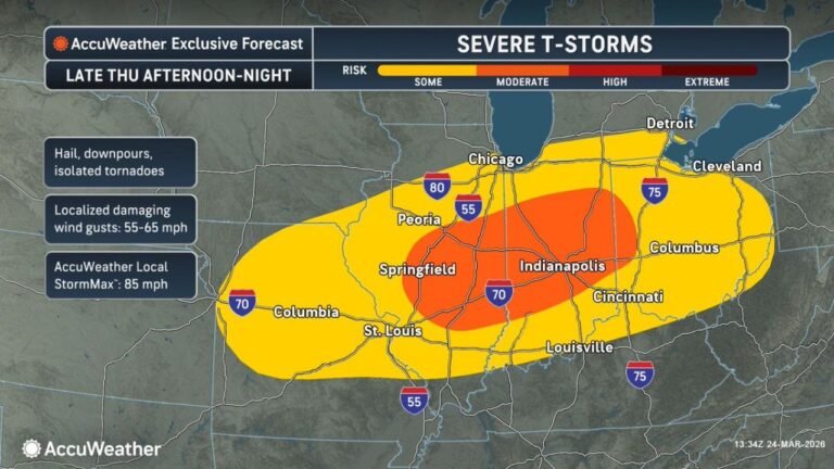
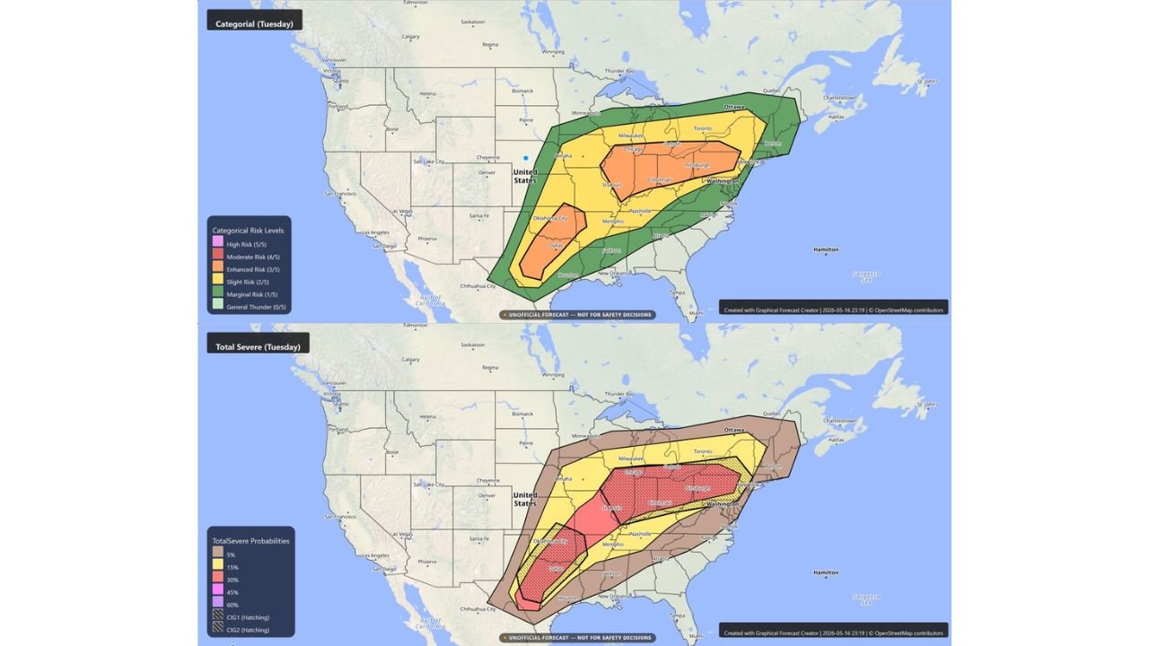
Unlike a single corridor threat, Tuesday’s setup features two distinct areas of Enhanced Risk developing simultaneously. The first sits over the Chicago, Detroit, Cincinnati, and Pittsburgh corridor across the upper Midwest and Great Lakes region. The second targets the Oklahoma City and Dallas corridor across the southern plains. Both zones carry Enhanced Risk status with the potential to be upgraded.
A CIG 2 Upgrade Is Already Being Discussed
Forecasters are watching this setup closely and have already raised the possibility of introducing a CIG 2 designation for portions of Ohio, Oklahoma, and Texas if confidence in the threat continues to increase. The CIG 2 level signals an especially dangerous severe weather setup and would represent a significant escalation in the Tuesday outlook.
The Full Risk Breakdown for Tuesday
| Risk Level | Areas Covered |
|---|---|
| Enhanced (3/5) | Chicago, Detroit, Cincinnati, Pittsburgh and Oklahoma City, Dallas zones |
| Slight (2/5) | Milwaukee, St. Louis, Memphis, Nashville and surrounding areas |
| Marginal (1/5) | Broader corridor extending across multiple states |
| General Thunder | Widest coverage area |
Total Severe Probability Zones for Tuesday
| Probability | Coverage |
|---|---|
| 30% | Core Enhanced Risk zones with CIG 1 hatching |
| 15% | Broader surrounding zone |
| 5% | Wide area across the region |
Both CIG 1 and CIG 2 hatching are present on the severe probability maps, with CIG 2 hatching covering portions of the southern and eastern threat zones, indicating the potential for particularly dangerous storm impacts in those areas.
What Tuesday’s Storms Could Bring
The combination of Enhanced Risk zones, CIG hatching, and 30 percent severe weather probabilities across two separate corridors points to a setup capable of producing damaging winds, large hail, and tornadoes across a wide stretch of the central and eastern United States on Tuesday.
Back to Back Days of Major Severe Weather
Tuesday follows directly on the heels of Monday’s historic severe weather outbreak. Residents across both threat corridors must remain on high alert and not let storm fatigue from Monday reduce their preparedness heading into Tuesday’s event.
Stay with CabarrusWeekly.com for the latest updates as Tuesday’s severe weather threat continues to develop.