15 Percent Severe Storm Probability Covers Plains and Mid-South Thursday and Friday With All Hazards on the Table
UNITED STATES — The Storm Prediction Center is carrying a 15 percent probability of severe thunderstorms on both Thursday April 23 and Friday April 24, with the threat shifting eastward across two consecutive days and all severe hazards — tornadoes, damaging winds, and large hail — possible on both days.
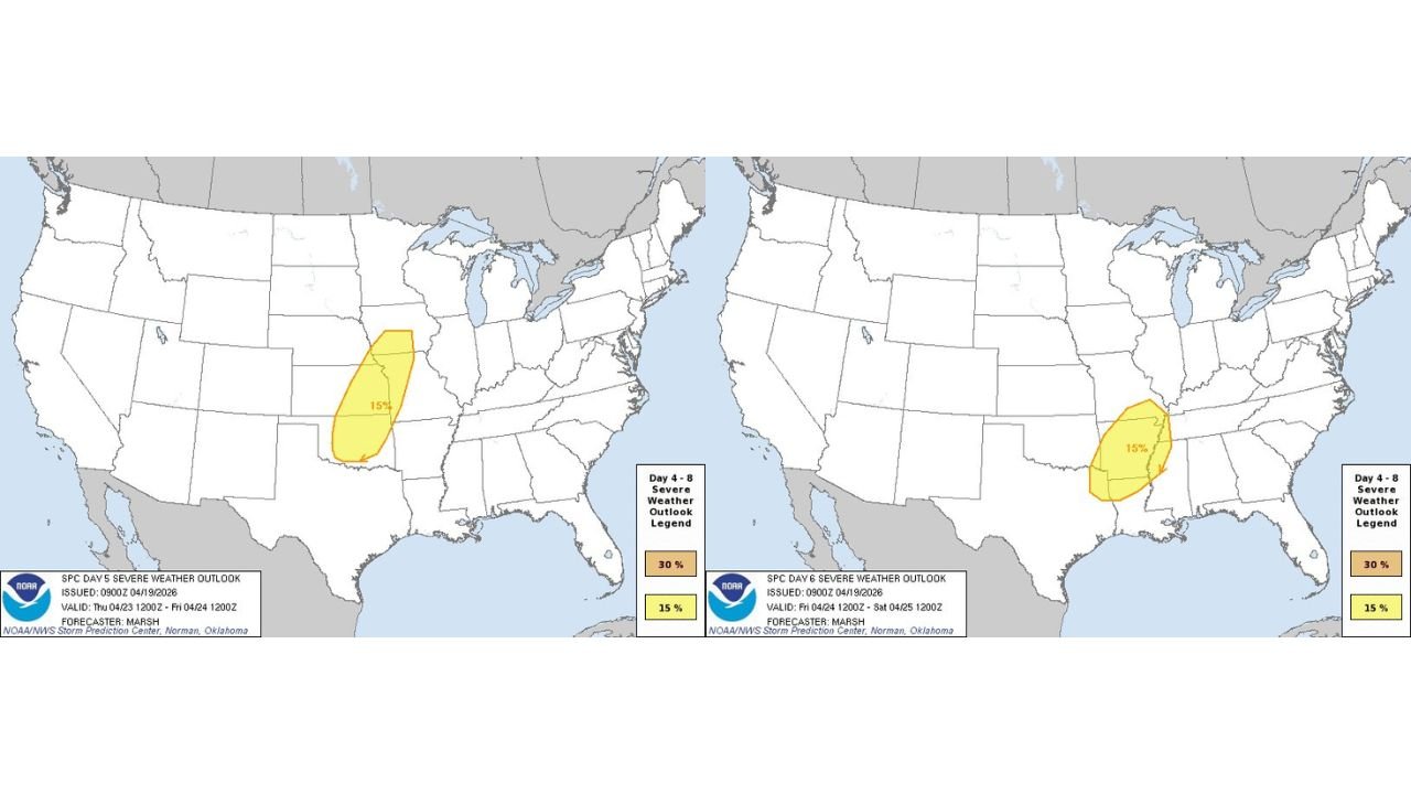
Thursday’s 15 Percent Severe Risk Targets the Central Plains
Thursday’s severe weather probability area covers a north-to-south corridor across the central Plains, stretching from eastern Kansas and western Missouri southward through much of Oklahoma. The 15 percent severe thunderstorm probability zone is well-defined and concentrated, indicating a focused but significant threat for the region during the Day 5 period.
All severe hazard types are explicitly possible within this zone on Thursday, meaning tornadoes, damaging wind gusts, and large hail each carry real potential as storm organization increases through the day.
Friday’s Threat Shifts East Into the Mid-South
By Friday April 24, the severe weather focus shifts eastward into the Mid-South, with the 15 percent probability zone repositioning across Arkansas, northern Louisiana, and western Mississippi and Tennessee. The Friday risk area is slightly more compact than Thursday’s but still represents a meaningful severe weather threat for Little Rock, Shreveport, Memphis, and Jackson.
Again, all severe hazards remain on the table for Friday’s event as storm energy tracks east with the advancing system.
| Day | SPC Probability | Primary Zone | Hazards |
|---|---|---|---|
| Thursday Apr 23 | 15% | Eastern Kansas, Oklahoma, W Missouri | Tornadoes, Wind, Hail |
| Friday Apr 24 | 15% | Arkansas, N Louisiana, W Tennessee | Tornadoes, Wind, Hail |
All Hazards Possible on Both Days
The explicit confirmation that all severe hazard types are possible on both days is a significant signal at this forecast range. It indicates the atmospheric setup is expected to support multiple storm modes — from supercells capable of tornadoes and large hail to organized squall lines producing widespread damaging winds.
Residents across the Plains and Mid-South should have severe weather plans finalized before Wednesday and stay alert to rapidly changing forecasts as the event approaches.
Stay with CabarrusWeekly.com for live severe weather probability updates across the Plains and Mid-South through Thursday and Friday.