8.4 Million People Face 15 Percent Severe Risk Thursday as 30 Percent Threat Locks In for Friday Across Oklahoma to Arkansas
UNITED STATES — The Storm Prediction Center has issued back-to-back severe weather outlooks covering Thursday April 23 and Friday April 24, with 8.4 million people falling inside Thursday’s 15 percent severe weather risk zone and an upgraded 30 percent severe weather probability locking in for Friday across a corridor stretching from Oklahoma City through Little Rock and into the Mid-South.
Thursday Day 5 — 8.4 Million at Risk From Wichita to Oklahoma City
The SPC Day 5 outlook valid Thursday April 23 places a 15 percent severe thunderstorm probability zone across a north-to-south corridor covering 112,718 square miles and directly threatening 8,433,545 people. The risk area covers Oklahoma City, Kansas City, Wichita, Tulsa, Liberal, Woodward, Fort Sill, and Lincoln, stretching from the southern Kansas border deep into central Oklahoma.
A stronger 30 percent severe weather area is also depicted within Thursday’s outlook, concentrated across the Wichita and southern Kansas corridor, indicating a focused zone of higher confidence for organized and impactful severe weather Thursday afternoon and evening.
Friday Day 6 — 30 Percent Risk Covers Oklahoma City to Little Rock and Shreveport
Friday’s outlook represents a significant upgrade in severe weather confidence, with a 30 percent severe thunderstorm probability — the highest tier depicted — now covering a large area centered on Oklahoma City, Tulsa, Fort Sill, Wichita Falls, Little Rock, Shreveport, and Greenville. A broader 15 percent zone surrounds this core, extending the threat area into Springfield, Memphis, Jackson, and Dallas.
The Friday 30 percent zone signals that widespread and organized severe thunderstorm activity is expected — not merely possible — across the Southern Plains and Mid-South on April 24.
| Day | SPC Risk | Area | Population | Core Cities |
|---|---|---|---|---|
| Thursday Apr 23 | 15% with 30% embedded | 112,718 sq mi | 8.4 million | OKC, Wichita, Tulsa, Kansas City |
| Friday Apr 24 | 30% severe | Larger footprint | Multi-million | OKC, Little Rock, Shreveport, Fort Sill |
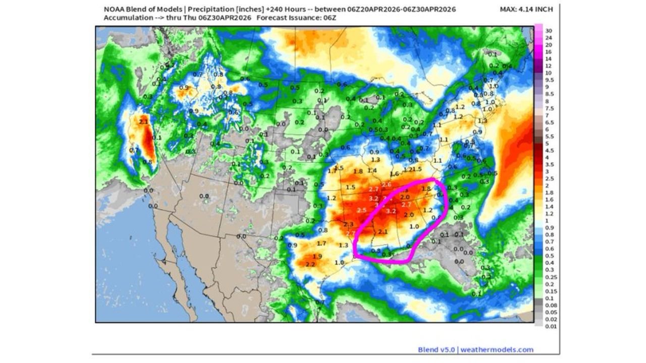
Up to 3.2 Inches of Rain Also Forecast Through April 30
Beyond the severe weather threat, the same storm system driving Thursday and Friday’s severe weather is also delivering significant rainfall totals across the Southern Plains and Mid-South through April 30. Blended precipitation forecasts show 2.5 to 3.2 inches concentrated across Oklahoma, Kansas, and Missouri, with a highlighted zone of heaviest totals circled across the Oklahoma and southern Kansas corridor. Additional rainfall of 1.5 to 2.0 inches extends into Arkansas and Tennessee.
California Drought Relief and Tennessee Valley Moisture Also in Play
The same system moving from California into the Plains is expected to end abnormally dry conditions across California while simultaneously opening the door to much-needed precipitation for the Tennessee Valley and Deep South. Florida and the Mid-Atlantic are expected to remain mostly dry through the next 10 days.
Severe Threat May Continue Through the Weekend
The multi-day severe weather pattern does not end with Friday. The SPC Day 7 and Day 8 outlooks extend the threat window into Saturday April 25 and Sunday April 26, with the storm system continuing to push eastward and maintaining severe weather potential across the Mid-South and Southeast through the weekend.
Stay with CabarrusWeekly.com for live severe weather probability and rainfall updates across Oklahoma, Kansas, Arkansas, and the Mid-South through the weekend.