2 Confirmed Tornadoes With 70 to 85 MPH Winds Barrel Toward Bloomington Illinois Right Now
BLOOMINGTON, ILLINOIS — A dangerous, fast-moving storm system is bearing down on central Illinois at this moment, with two confirmed tornadoes embedded within a fast-moving squall line tracking directly toward the Bloomington and Normal area — threatening lives across the region right now.
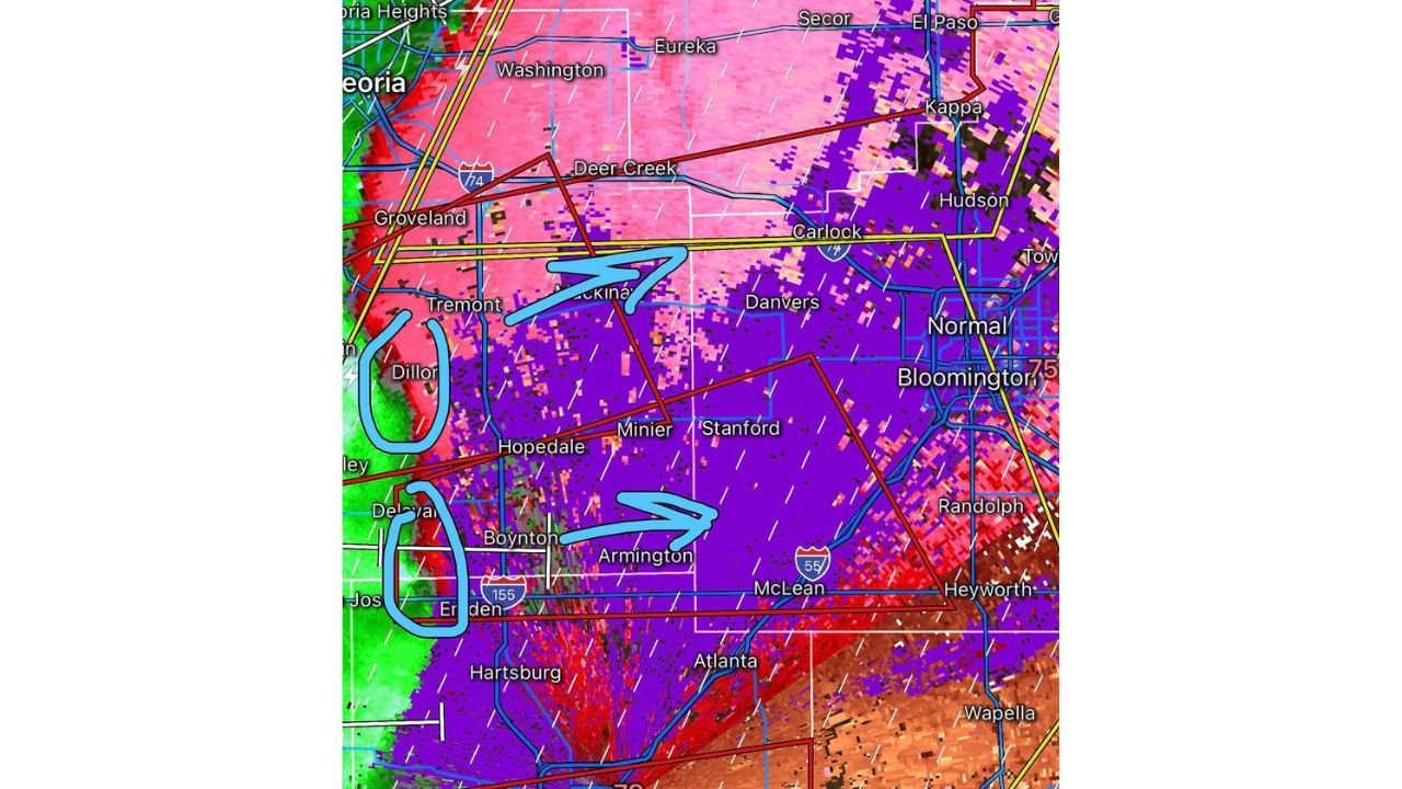
Two Confirmed Tornadoes on the Ground Moving East
Radar velocity data confirms two active tornado circulations rotating within the squall line as it charges eastward. The storm system is moving at high speed, leaving little time for residents in its path to seek shelter. The tornado warning polygons shown on radar extend from the Tremont and Dillon area through Hopedale, Minier, Stanford, and directly into Bloomington and Normal.
Communities including Carlock, Danvers, McLean, Armington, Boynton, and Heyworth are all within the immediate threat zone as the line continues to push east.
70 to 85 MPH Winds and Large Hail Accompany the Tornadoes
Beyond the confirmed tornado threat, the squall line is producing damaging straight-line winds of 70 to 85 MPH or greater across a wide swath of the warning area. Large hail is also possible with the strongest cells embedded within the line. This combination of hazards makes this an extremely dangerous situation for anyone caught outdoors or in an unprotected structure.
| Hazard | Intensity |
|---|---|
| Active Tornadoes | 2 Confirmed |
| Damaging Winds | 70 to 85+ MPH |
| Hail | Large hail possible |
| Storm Motion | Fast-moving east |
Bloomington and Areas East Must Take Cover Immediately
If you are in Bloomington, Normal, or any community east of the current storm position, take the following actions right now. Get to a basement or the lowest interior room of a sturdy structure immediately. Stay away from all windows. Do not attempt to outrun the storm by vehicle. This is a life-threatening situation requiring immediate action.
The fast storm motion means conditions can deteriorate within minutes with little additional warning time.
Stay with CabarrusWeekly.com for live tornado and severe weather updates across central Illinois.