Temperatures to Run 2 to 5 Degrees Below Normal Across the Midwest and East Coast From April 30 Through May 5
UNITED STATES — A significant pattern change is arriving just as May begins, with below-normal temperatures expected to grip a massive corridor from the Northern Plains through the Midwest, Ohio Valley, and all the way to the Mid-Atlantic and Northeast from April 30 through May 5, 2026 — and bringing with it a renewed frost and freeze risk across portions of the Midwest and Ohio Valley that many thought was finished for the season.
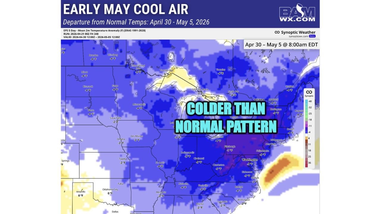
2 to 5 Degrees Below Normal Across a Massive Multi-State Zone
Temperature anomaly data valid April 30 through May 5 shows a sweeping below-normal pattern blanketing virtually the entire eastern two-thirds of the country. The deepest negative anomalies — running 4 to 5 degrees below normal — are concentrated across a corridor covering Pittsburgh, Cleveland, Indianapolis, Cincinnati, Charleston, Philadelphia, Washington DC, Richmond, and Burlington, with the cold anomaly extending northward through the Great Lakes and into Canada.
Additional cities running 2 to 4 degrees below normal include Minneapolis, Des Moines, Omaha, St. Louis, Nashville, Knoxville, Raleigh, and Atlanta, meaning the below-normal pattern reaches from the Northern Plains deep into the Southeast.
| Region | Temperature Departure | Key Cities |
|---|---|---|
| Ohio Valley and Mid-Atlantic | 4 to 5°F below normal | Pittsburgh, Cincinnati, Philadelphia, DC |
| Great Lakes and Northeast | 4 to 5°F below normal | Cleveland, Burlington, Boston area |
| Central Midwest and Plains | 2 to 4°F below normal | Minneapolis, Des Moines, St. Louis |
| Southeast | 2 to 4°F below normal | Nashville, Raleigh, Atlanta |
| Southern Plains | Near normal | Oklahoma City, Amarillo |
Frost and Freeze Risk Not Done Yet Across the Midwest and Ohio Valley
The incoming below-normal temperature pattern means the frost and freeze season is likely not finished for portions of the Midwest and Ohio Valley heading into early May. After a relatively mild spring overall, the combination of well-below-normal overnight lows and clear sky radiational cooling conditions creates the potential for additional damaging frost events across agricultural areas that may have already initiated planting activity.
With corn planting at just 5 percent and soybean planting at 6 percent nationally, the timing of this cold intrusion heading into the critical early May planting window adds additional concern for growers across the Corn Belt.
Pattern Arrives After One of the Warmest Springs on Record
The shift into below-normal temperatures arrives following what has been one of the warmest March-April stretches in recorded history across much of the eastern United States. The abrupt transition from record warmth to a sustained below-normal pattern heading into May underscores the volatile and amplified atmospheric pattern dominating the spring of 2026.
Stay with CabarrusWeekly.com for continuing temperature and frost risk updates across the Midwest, Ohio Valley, and East Coast through early May.