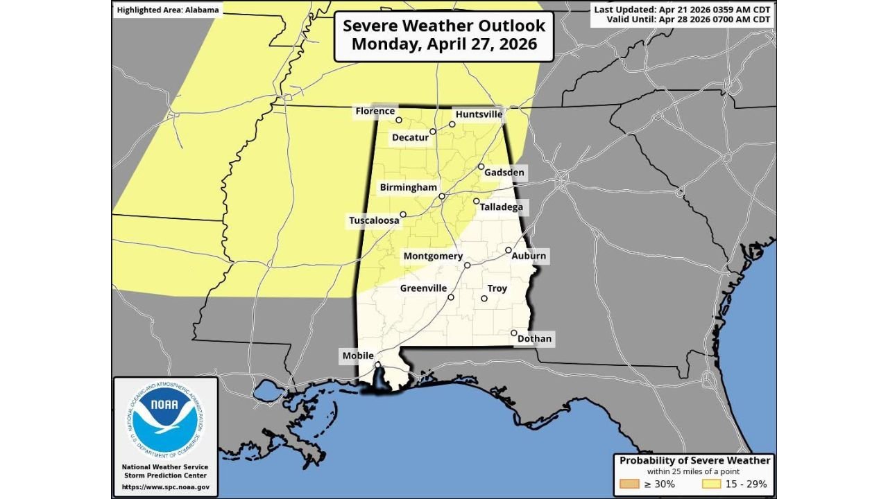
Severe Thunderstorm Risk Outlined for North and West Alabama Monday April 27 as Pattern Change Opens the Door
NORTH ALABAMA — The Storm Prediction Center has formally defined a severe thunderstorm risk across much of North and West Alabama for Monday April 27, 2026, with a 15 to 29 percent severe weather probability zone covering a broad swath of the state from Florence and Huntsville southward through Birmingham, Tuscaloosa, Montgomery, and into the central counties — as a significant pattern change begins unlocking more active weather across the Deep South.
Risk Zone Covers Florence to Montgomery and West Alabama
The severe weather outlook valid Monday April 27 shows the risk corridor cutting across the western two-thirds of Alabama. Cities directly within the 15 to 29 percent probability zone include Florence, Decatur, Huntsville, Gadsden, Birmingham, Tuscaloosa, Talladega, Montgomery, Auburn, Greenville, and Troy. The 30 percent or higher zone pushes into West Alabama and the state’s western border counties, indicating the highest confidence area for organized severe storm development sits along the western half of the state.
Eastern Alabama counties including Dothan and the far southeast currently sit outside the defined risk area but should monitor updates as the forecast evolves through the week.
Pattern Change Bringing Rain and Storm Risk to the Deep South
Monday’s severe weather threat is the direct result of a broader pattern change now taking shape across the Deep South, which will increase the frequency of rain and storm-producing systems across the region over the coming weeks. This shift carries a dual nature — bringing much-needed rainfall to drought-stressed areas of Alabama while simultaneously introducing periodic severe storm risks each time a stronger system moves through.
| Zone | Probability | Cities Included |
|---|---|---|
| West Alabama border counties | 30%+ | Western corridor |
| North and Central Alabama | 15 to 29% | Florence, Huntsville, Birmingham, Montgomery |
| Eastern Alabama | Outside current risk | Dothan, southeast AL |
Too Early for Specific Details — Threat Needs Monitoring All Week
Forecasters are clear that it is too early to determine the specific magnitude, timing, and hazard types associated with Monday’s threat. The outlook will be refined significantly as the week progresses and models converge on a solution. Residents across North and West Alabama should avoid overreacting to early social media speculation and instead follow updated official forecast information through the week as confidence builds.
What is already established is that a defined severe weather risk exists for Monday and that Alabama is entering a more active period of weather that will demand attention through the remainder of April and into May.
Stay with CabarrusWeekly.com for live severe weather outlook updates across North and West Alabama through Monday April 27.