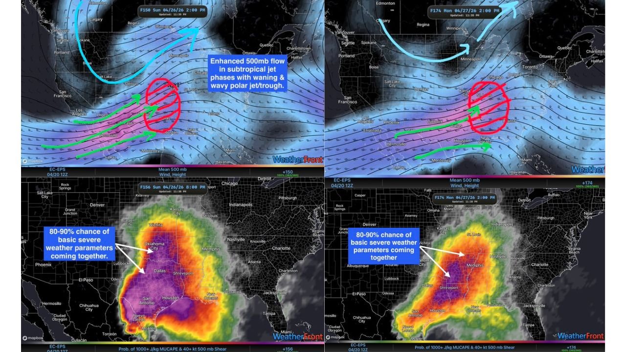
80 to 90 Percent Chance of Severe Weather Parameters Converging Across the Southern Plains Sunday April 26 and Monday April 27
SOUTHERN PLAINS — Ensemble atmospheric data is painting one of the most striking severe weather setups of the 2026 spring season for Sunday April 26 and Monday April 27, with an 80 to 90 percent probability of basic severe weather parameters coming together across the Southern Plains on both days — driven by a powerful jet stream configuration that professional storm chasers are already describing as a high-end severe weather look.
80 to 90 Percent Severe Parameter Probability — Both Days
Ensemble probability data valid Sunday April 26 at 2:00 PM shows the 80 to 90 percent probability zone for severe weather parameters — including MUCAPE above 500 J/kg and 40-plus knot wind shear at 500mb — concentrated across a broad swath covering Oklahoma, Texas, and the surrounding Southern Plains. The deep purple and magenta shading on the ensemble probability maps extends across virtually the entire state of Texas and Oklahoma, with the highest values centered across central and southern Oklahoma, north Texas, and the Dallas corridor.
By Monday April 27 at 2:00 PM, the same 80 to 90 percent probability zone shifts slightly eastward, with the highest ensemble parameter values repositioning across eastern Texas, Louisiana, Mississippi, Arkansas, and the Tennessee Valley corridor — keeping the threat alive and moving into the Deep South.
Powerful Jet Stream Configuration Drives the Setup
Upper-level atmospheric analysis valid both days shows a potent subtropical jet stream interacting with a wavy polar jet and trough system across the central United States — the classic late-April configuration that historically produces the most dangerous and organized severe weather outbreaks across the Southern Plains and Deep South. The jet stream positioning places the maximum wind shear and divergence zones directly over the highest instability areas on both days, creating near-ideal conditions for supercell thunderstorm development.
Sunday Risk Maximized Over the Southern Plains
Sunday’s severe weather risk is currently maximized over the Southern Plains, with the combination of rich Gulf moisture, strong wind shear, and powerful jet forcing creating the most favorable environment for organized supercells capable of significant tornadoes, very large hail, and destructive winds across Oklahoma, Texas, and neighboring states.
| Day | 80-90% Parameter Zone | Jet Configuration |
|---|---|---|
| Sunday Apr 26 | Oklahoma, Texas, Southern Plains | Subtropical jet phasing with polar trough |
| Monday Apr 27 | E Texas, Louisiana, MS, Arkansas, TN Valley | Jet shifts east with system |
High-End Severe Weather Potential Rarely Seen This Early
The ensemble signal showing 80 to 90 percent severe parameter probability at this forecast range across such a large geographic area is a rare and serious atmospheric signal. Combined with the favorable jet stream phasing, this data points toward a high-end severe weather event for the Southern Plains Sunday and the Deep South Monday — one that demands immediate attention and preparation from residents across the entire affected corridor.
Stay with CabarrusWeekly.com for live severe weather parameter and outbreak potential updates across the Southern Plains and Deep South through Monday April 27.