Classic Great Plains Outbreak With Baseball Sized Hail EF2 Tornadoes and 70 MPH Winds Targets Kansas Oklahoma and North Texas Saturday and Sunday
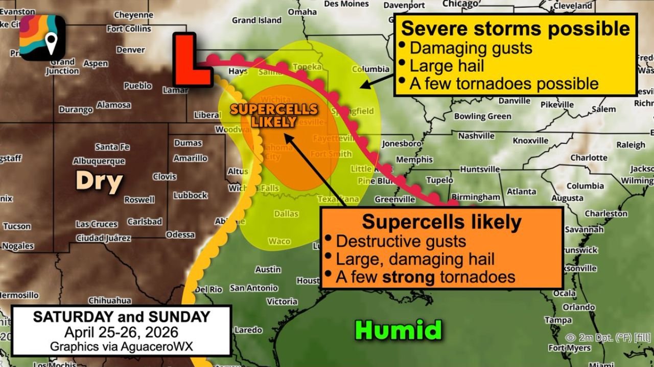
KANSAS — A classic Great Plains severe weather outbreak is taking shape for Saturday and Sunday April 25 and 26, 2026, with all of the textbook atmospheric ingredients converging across Kansas, Oklahoma, North Texas, and western Arkansas to produce what forecasters are describing as a significant severe weather event — including baseball-sized or larger hail, straight-line winds exceeding 70 MPH, and a few strong EF2 or greater tornadoes.
Lee Cyclogenesis Triggers the Outbreak
The engine driving this weekend’s outbreak is a strengthening low pressure system developing in the lee of the Colorado Rockies — a process known as lee cyclogenesis. This deepening surface low will pull warm and humid air northward from the Gulf of Mexico, loading the atmosphere with exceptional instability and thunderstorm fuel across the central Plains.
As dry desert air from the west collides with the moist air mass to the east along the dryline, widely scattered supercell thunderstorms are expected to erupt during the afternoon hours both Saturday and Sunday.
Supercells Likely — Spinning Storms in a Roaring Jet Stream
The jet stream roaring overhead will provide the rapidly changing winds with altitude needed to generate rotation within developing thunderstorms. This wind shear profile is the critical ingredient that transforms ordinary thunderstorms into organized, long-track supercells — the storm type most responsible for significant tornadoes, baseball-sized hail, and extreme straight-line winds.
Two distinct threat zones are now being outlined for the weekend:
Northern zone — covering portions of Kansas, Nebraska, and the central Plains — faces damaging gusts, large hail, and a few tornadoes. Southern zone — centered across Oklahoma, North Texas, and the Texas Panhandle corridor — carries the highest threat, with supercells likely, destructive gusts, large damaging hail, and a few strong tornadoes including EF2 or stronger.
| Zone | Location | Primary Hazards |
|---|---|---|
| Northern threat | Kansas, Nebraska corridor | Damaging gusts, large hail, tornadoes |
| Southern supercell zone | Oklahoma, N Texas, TX Panhandle | Destructive gusts, baseball hail, EF2+ tornadoes |
Baseball Sized Hail and 70 MPH Winds Expected With Strongest Storms
The strongest supercells this weekend are expected to produce baseball-sized hail or larger, capable of shattering windows, destroying vehicles, and causing significant structural damage. Straight-line winds of 70 MPH or greater are also expected with the most intense storms, while the tornado threat — though concentrated — carries the potential for significant and long-track tornado touchdowns across the southern supercell zone.
Textbook Hallmarks of a Major Outbreak Already Present
Forecasters note that this setup already displays textbook hallmarks of a significant severe weather event — strong jet stream, deep moisture return, explosive instability, and lee cyclogenesis all converging simultaneously over the traditional Tornado Alley corridor during peak late April severe weather season.
Residents across Kansas, Oklahoma, North Texas, and western Arkansas should begin reviewing severe weather plans immediately and ensure shelter locations are identified before Saturday afternoon.
Stay with CabarrusWeekly.com for daily updates on the Saturday and Sunday Great Plains outbreak through the weekend.