Particularly Dangerous Situation Red Flag Warnings Cover 11 Million People Across the Rockies and Plains With Extreme Fire Risk Wednesday
INTERMOUNTAIN WEST — A life-threatening and Particularly Dangerous Situation fire weather emergency is unfolding across the Intermountain West, Rockies, and Plains today, with Red Flag Warnings issued for more than 11 million people and portions of the region elevated to the most extreme fire weather designations on the scale — meaning a single ignition could trigger a catastrophic wildfire threatening both rural and urban communities.
Extreme and Critical Fire Weather Risk Covers Rockies and High Plains
The SPC Day 1 Fire Weather Outlook valid Wednesday April 22 shows a dramatic and dangerous fire weather pattern across a large multi-state zone. An Extreme Risk — Level 3 zone — the highest designation on the fire weather scale — is depicted across a concentrated corridor running from northern New Mexico and southern Colorado northward through central Colorado and into Wyoming. This Extreme zone indicates exceptional fire spread potential with any ignition.
Surrounding the Extreme core, a broad Critical Risk — Level 2 zone extends across Wyoming, Montana, the Dakotas, Nebraska, and Kansas, with an additional Critical zone positioned over portions of North and South Carolina on the eastern seaboard. A wider Elevated Risk — Level 1 zone covers the broader surrounding region across the central and southern Plains.
Particularly Dangerous Situation — Life and Property at Risk
Several of the Red Flag Warnings issued today have been designated as Particularly Dangerous Situations — a special classification reserved for the most extreme fire weather days where a fire starting under current conditions could pose a significant and immediate threat to both life and property in rural and urban environments alike. This designation is not issued routinely and reflects forecaster confidence that today’s wind, humidity, and fuel conditions are at their most dangerous combination.
| Risk Level | Zone | States |
|---|---|---|
| Extreme — Level 3 | Central Colorado to Wyoming corridor | Colorado, Wyoming, New Mexico |
| Critical — Level 2 | Northern and central Plains | Montana, Dakotas, Nebraska, Kansas |
| Critical — Level 2 | Eastern seaboard | North and South Carolina |
| Elevated — Level 1 | Broader surrounding zone | Central and southern Plains |
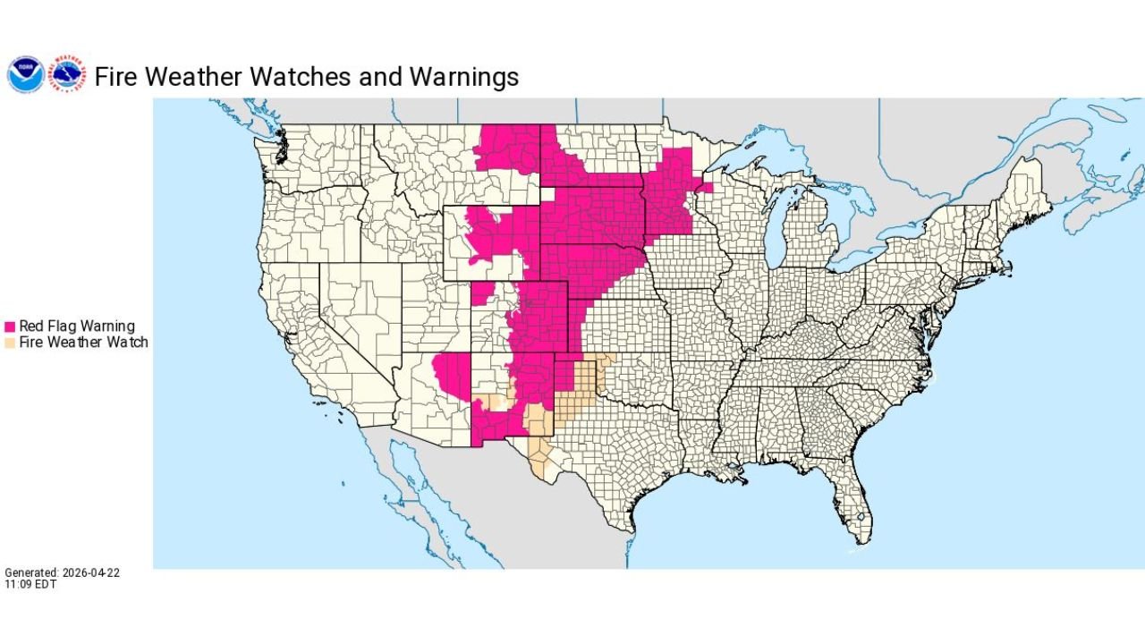
Red Flag Warnings Blanket a Massive Multi-State Corridor
Fire Weather Watch and Warning mapping valid April 22 shows Red Flag Warnings — shown in pink — covering an enormous north-to-south corridor from the Northern Plains through the central Rockies, southern Plains, and into New Mexico and West Texas. The warning footprint is one of the largest single-day fire weather warning areas seen across the region this spring, stretching from the Canadian border southward through Oklahoma and New Mexico.
Fire Weather Watches — indicating conditions approaching critical thresholds — are in place across portions of New Mexico and West Texas just south of the active warning zone.
What Residents Must Avoid Today
With Particularly Dangerous Situation designations in effect, authorities are issuing explicit and urgent guidance for all residents within the Red Flag Warning zone. Debris burning is strictly prohibited. Campfires must not be started under any circumstances. Any outdoor activity or use of equipment capable of producing a spark — including mowing, welding, or off-road vehicles — should be completely avoided today. Residents should follow all local fire restrictions and monitor weather.gov for the latest updates.
Stay with CabarrusWeekly.com for live Red Flag Warning and fire weather updates across the Rockies, Plains, and Intermountain West through Thursday.