Tornado Probability Explodes to High Threat Level Near Memphis for Monday April 27 in One of the Most Alarming Extended Range Signals of 2026
MEMPHIS, TENNESSEE — Tornado probability data initialized Tuesday night April 22 is producing one of the most striking and alarming extended-range tornado signals seen so far in the 2026 spring season, with the core threat zone for Monday April 27 now reaching into the high tornado threat range of 0.5 to 0.6 — centered directly on the Memphis corridor and surrounding Mid-South — a forecast range signal that demands immediate attention across the region.
Core Threat Reaches High Range — Centered on Memphis
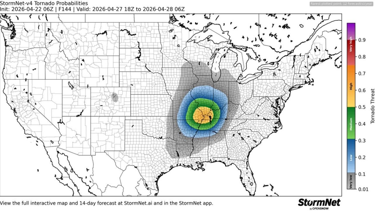
Tornado probability data valid April 27 18Z through April 28 06Z shows a tightly concentrated and rapidly intensifying threat bull’s-eye positioned across the Memphis, Tennessee area and the surrounding Mississippi Valley corridor. The innermost core of the probability zone — shown in yellow and green — reaches 0.5 to 0.6 on the tornado threat scale, placing this forecast squarely into the high threat category.
This is a dramatic intensification from earlier runs of the same forecast data, which showed only low to medium probability values for Monday. The rapid upward trend in the probability signal at 5 days out is a serious meteorological red flag for the region.
Concentric Rings Extend Threat Across Tennessee, Mississippi, Alabama and Arkansas
The concentric probability structure surrounding the Memphis core extends the tornado threat across a broad multi-state zone. The medium threat zone of 0.4 to 0.5 covers a wide area including western Tennessee, northern Mississippi, eastern Arkansas, and portions of Alabama. A broader low threat zone of 0.2 to 0.3 extends further outward across Kentucky, Indiana, Missouri, and the broader Deep South.
| Threat Zone | Probability | Coverage Area |
|---|---|---|
| Core bull’s-eye | 0.5 to 0.6 (High) | Memphis corridor, Mississippi Valley |
| Inner zone | 0.4 to 0.5 (Medium) | W Tennessee, N Mississippi, E Arkansas |
| Surrounding zone | 0.2 to 0.3 (Low) | Kentucky, Indiana, Alabama, Missouri |
| Outer fringe | 0.1 to 0.2 (Very Low) | Broader Mid-South and Ohio Valley |
Signal Strengthening Rapidly at 5 Days Out
The fact that tornado probability values are reaching the high threat threshold at 5 days out — and trending upward from earlier forecast runs — is an extremely uncommon occurrence and reflects strong and growing model agreement on a significant tornado-producing setup for Monday across the Mississippi Valley. Extended range forecasts at this level of intensity and definition rarely occur without a significant weather event following.
This signal, combined with the SPC’s already-issued Slight Risk outlook and elevated NOAA/NSSL storm probability data for Monday, paints a cohesive and concerning picture that strongly suggests Monday April 27 carries the potential to be one of the most significant tornado days of the 2026 spring season.
Residents across Memphis, Nashville, Birmingham, Jackson Mississippi, and the broader Mississippi Valley should treat this as an urgent and developing threat requiring immediate preparation — not a distant or uncertain possibility.
Stay with CabarrusWeekly.com for daily tornado probability and severe weather updates across the Mississippi Valley through Monday April 27.