Monday April 27 Severe Weather Ceiling Remains High as Tennessee Arkansas and Illinois Face Significant Risk With Models Trending North
MID-SOUTH, UNITED STATES — Monday April 27 continues to carry the potential for a fairly significant severe weather episode across a broad corridor stretching from the Mid-South through the Midwest, with the latest atmospheric guidance showing a northward trend in the upper trough and surface low that is expanding the risk zone deeper into the Midwest while still maintaining a serious threat across portions of the South.
Both Major Forecast Systems Agree on a Large Severe Weather Zone
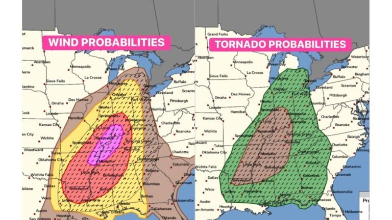
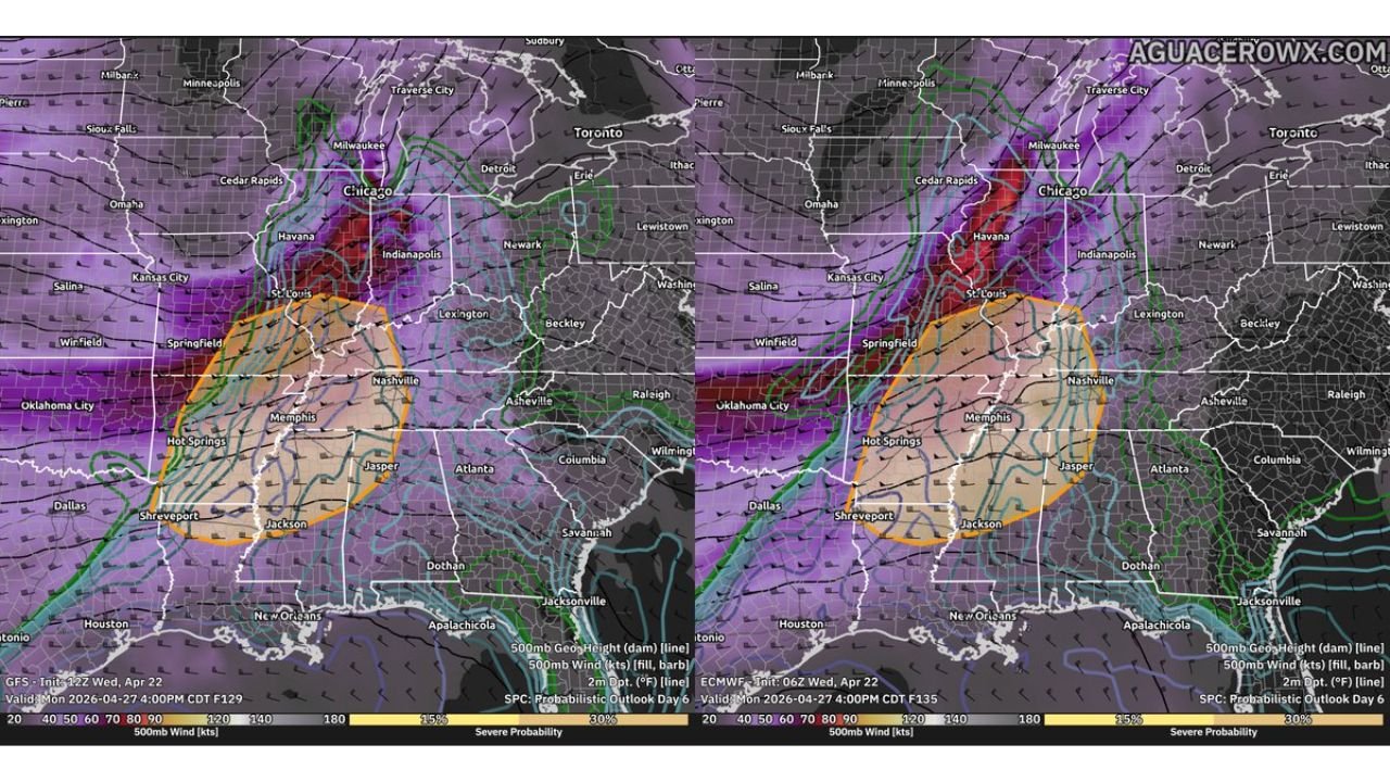
Atmospheric data valid Monday April 27 at 4:00 PM CDT from two major global forecast systems shows strong agreement on the overall severe weather setup, with both depicting a large warm sector and severe probability zone centered across a corridor from Springfield and St. Louis southward through Memphis, Hot Springs, Nashville, and Jackson. The orange-shaded severe probability areas on both solutions overlap significantly across the Memphis to Nashville and Springfield to Jackson corridor — indicating high confidence in this region remaining at elevated risk regardless of which solution verifies.
Both systems also show 30 percent or greater severe probability across the core of the risk zone, with the highest values concentrated across the Memphis, Springfield, and Hot Springs area.
Northward Trend Expanding Risk Into the Midwest
Recent trends in both global deterministic and ensemble guidance are pointing toward the upper trough and surface low tracking further north than previously expected. If this northward trend continues, it would expand the severe weather risk zone to include more of the Midwest region — including Chicago, Indianapolis, and St. Louis — while simultaneously maintaining the threat for portions of the South. Both model solutions already show deep purple upper-level wind values pushing through Chicago and the Great Lakes, consistent with a more northerly storm track.
Monday’s Ceiling Remains High — Significant Episode Still Possible
Despite the remaining forecast uncertainty around exact storm track and timing, forecasters are clear that Monday’s ceiling remains high — meaning the potential exists for this event to escalate into a significant and impactful severe weather episode. The key unknowns still being worked out include the timing and amplitude of the upper trough and how Sunday’s convective activity ahead of the system affects Monday’s severe weather environment.
| Element | Current Status |
|---|---|
| Primary risk zone | Springfield, Memphis, Nashville, Hot Springs, Jackson |
| Expanding risk | Chicago, Indianapolis, St. Louis corridor |
| Severe probability core | 30 percent or greater |
| Forecast trend | Northward — broader Midwest exposure increasing |
| Monday’s ceiling | High — significant episode remains possible |
Mid-South and Midwest Residents Must Stay Alert
With the risk zone potentially expanding northward while still threatening the Mid-South, residents across Memphis, Nashville, Springfield, Hot Springs, Jackson, St. Louis, Indianapolis, and Chicago should treat Monday as a developing and serious severe weather day requiring active monitoring through the week. Forecast details will sharpen significantly as Sunday’s convective activity evolves and updated guidance becomes available.
Stay with CabarrusWeekly.com for daily severe weather updates across the Mid-South and Midwest through Monday April 27.