Eastern Oklahoma and Western Arkansas Brace for Softball-Sized Hail and Rotating Supercells This Saturday April 25
EASTERN OKLAHOMA AND WESTERN ARKANSAS — Saturday, April 25, 2026 is shaping up as a classic major hail event across eastern Oklahoma and far western Arkansas, with scattered hail-producing rotating supercells expected to develop east of I-35 around 3:00 PM and the most intense storms capable of producing hail between 3 and 4 inches in diameter — larger than baseballs and approaching softball size.
Why This is a Big Hail Day
Three atmospheric factors are combining to create exceptional hail growth potential on Saturday.
Mid-level spin is the dominant driver. Wind dynamics are supportive of rotating storms, with the greatest spin occurring at the mid-levels of the atmosphere — the ideal configuration for maximizing hailstone size. While low-level winds are somewhat weak, limiting the tornado threat, that same mid-level rotation is perfect for producing extremely large hail.
Dry air at mid-levels means less moisture is converting to rainfall inside storm clouds. Instead, supercooled water droplets remain available to coat and grow hailstones as they are lofted repeatedly through the storm’s updraft — a direct contributor to oversized hail.
Steep lapse rates — temperatures dropping rapidly with altitude — mean hailstones encounter exceptionally cold air as updrafts carry them upward, locking in their size and structure before they fall.
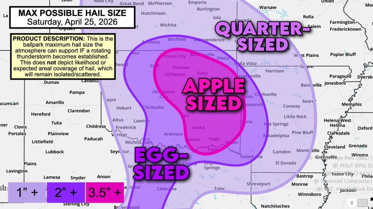
Maximum Possible Hail Sizes by Zone
| Zone | Max Possible Hail Size | Areas |
|---|---|---|
| Egg-sized (3.5 inches+) | Largest threat | Central and southern Oklahoma, Ardmore, Atoka, Hugo, Durant |
| Apple-sized (2 inches+) | Elevated threat | Oklahoma City, Tulsa, Stillwater, Ada, McAlester, Fort Smith |
| Quarter-sized (1 inch+) | Broad threat | Northern Oklahoma, Bartlesville, far western Arkansas |
These sizes represent the maximum the atmosphere can support if a rotating thunderstorm becomes established — hail coverage will remain isolated to scattered, not widespread.
SPC Hail Areal Coverage Outlook
The Storm Prediction Center outlook for Saturday identifies:
- Several hailstorms zone: Central Oklahoma through Tulsa, Stillwater, Oklahoma City, McAlester, and into far western Arkansas including Fort Smith
- Scattered hail zone: Far western Arkansas, Texarkana corridor, and surrounding areas
- Isolated hail zone: Southern Oklahoma, northern Texas panhandle region
Timing and Initiation
Supercells are expected to begin firing east of I-35 around 3:00 PM Saturday and will track eastward through the afternoon and evening, impacting much of eastern Oklahoma and far western Arkansas. A couple of tornadoes cannot be ruled out given the rotating storm environment, though the tornado threat is limited by the weak low-level wind profile.
Protect Vehicles and Property Now
With hail potentially reaching egg to softball size, vehicle and property damage is a serious concern. Residents across eastern Oklahoma and western Arkansas are strongly urged to park vehicles in garages, carports, or sheltered locations before storms arrive Saturday afternoon.
Stay with CabarrusWeekly.com for continuing updates on Saturday’s major hail threat across Oklahoma and Arkansas.