Kansas and Oklahoma Under Active Tornado and Very Large Hail Threat as Dangerous Storms Continue Thursday Evening
KANSAS AND OKLAHOMA — An extremely dangerous severe weather environment is in progress across Kansas and Oklahoma this Thursday evening, April 23, 2026, with the threat for very large hail and significant tornadoes expected to continue for at least 2 to 3 or more hours as multiple intense storm cells track through the region.
Greatest Tornado Threat Focused on Northern Oklahoma
Forecasters are pointing to cells in northern Oklahoma as carrying the greatest tornado threat at this time. A secondary and potentially increasing tornado threat is also developing with new cells forming in southwest Oklahoma, which could intensify as the evening progresses.
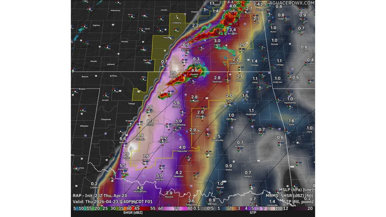
The radar valid at 7:40 PM CDT shows intense storm cores tracking through a corridor from south-central Kansas through northern and central Oklahoma, with the highest STP values concentrated along this corridor.
STP Values Confirm a Violent Storm Environment
The Significant Tornado Parameter values displayed across the radar are exceptionally high, confirming a deeply dangerous atmospheric setup:
| Location | STP Value |
|---|---|
| Waynoka / northwest Oklahoma | 9.0 |
| Hinton area | 8.3 |
| Carnegie / Chickasha corridor | 8.8 |
| Lawton area | 7.6 |
| Snyder area | 7.0 |
| Medford / Newkirk (northern OK) | 7.8 |
| Wichita, Kansas | 6.7 |
| Winfield, Kansas | 6.3 |
| Stillwater area | 5.6 |
| Oklahoma City corridor | 5.0 – 6.2 |
STP values of this magnitude — several readings between 7 and 9 — represent an environment capable of producing violent, long-track tornadoes.
Hazards Continuing Through the Evening
- Significant tornadoes — ongoing threat across northern and southwest Oklahoma, continuing for 2 to 3 or more hours
- Very large hail — threat persists with all active supercell storms
- Damaging straight-line winds — possible with any organized cell
Who Is at Risk Right Now
The immediate danger zone stretches across a broad corridor including Wichita, Medford, Newkirk, Enid, Stillwater, Oklahoma City, Chickasha, Lawton, and Frederick in Oklahoma, and into south-central Kansas. New storm development in southwest Oklahoma means the threat zone may expand through the remainder of the evening.
Anyone in the path of these storms should be sheltered now. Do not wait for a tornado to be confirmed before taking action in this environment.
Stay with CabarrusWeekly.com for continuing live coverage of this dangerous severe weather outbreak across Kansas and Oklahoma.