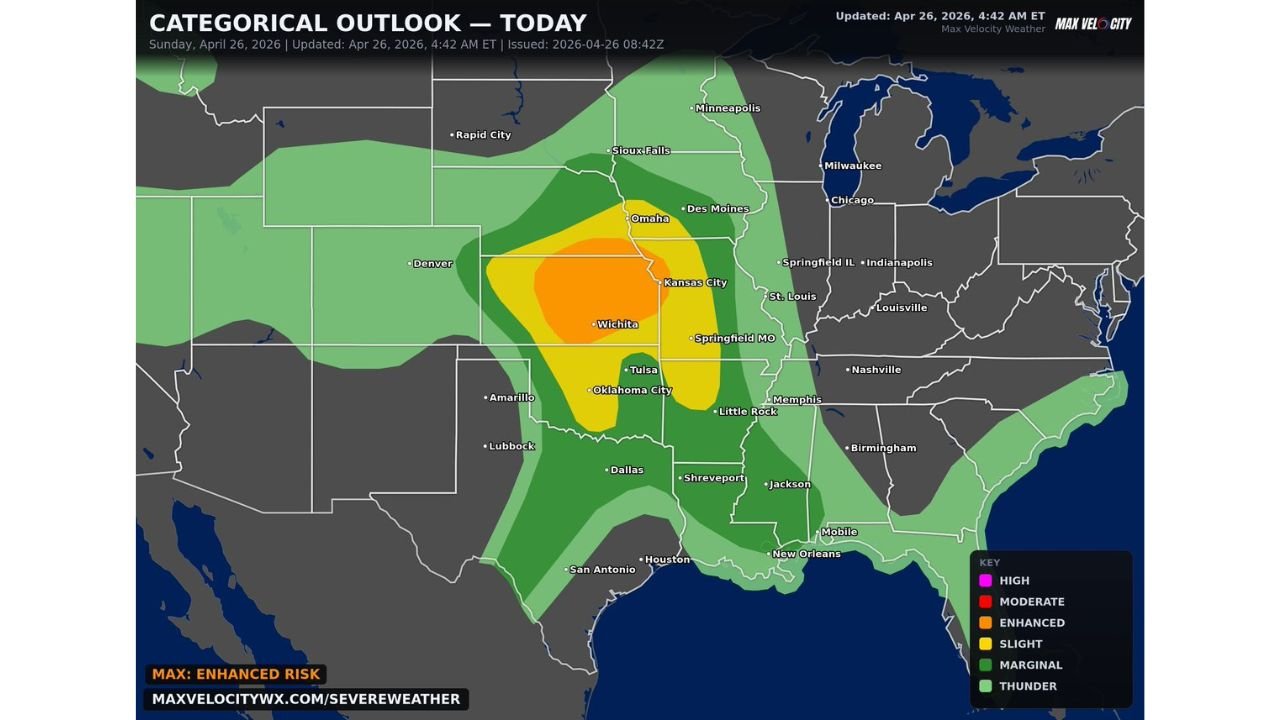
Kansas, Oklahoma and Missouri Face Dangerous Severe Weather Day With Very Large Hail, Damaging Winds and Strong Tornadoes Today April 26
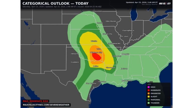
CENTRAL AND SOUTHERN PLAINS — A dangerous severe weather day is underway across the Central and Southern Plains on Sunday, April 26, 2026, with an Enhanced Risk (Level 3 of 5) centered on Kansas, Oklahoma, and Missouri, and very large hail, damaging winds, and a few strong tornadoes all possible through the afternoon and evening hours.
Enhanced Risk at the Core
The categorical outlook issued April 26 places the Enhanced Risk zone across a corridor stretching from Wichita and Oklahoma City through Tulsa and into Kansas City and Springfield, Missouri. This is the highest risk zone for today and represents the area most likely to see organized, significant severe weather.
Risk Zone Breakdown
| Risk Level | Key Cities |
|---|---|
| Enhanced Risk — Level 3 | Wichita, Oklahoma City, Tulsa, Kansas City, Springfield MO |
| Slight Risk — Level 2 | Omaha, Des Moines, Little Rock, Memphis, Dallas, Shreveport |
| Marginal Risk — Level 1 | Minneapolis, Sioux Falls, Jackson, Birmingham, New Orleans, Houston |
Primary Hazards Today
- Very large hail — the dominant and most widespread threat across the Enhanced Risk zone
- Damaging winds — possible with any organized severe storm
- A few strong tornadoes — possible particularly within the Enhanced Risk corridor
Prepare Before Storms Arrive
Residents across Kansas, Oklahoma, Missouri, and surrounding states within the Enhanced and Slight Risk zones should be actively monitoring conditions today. Vehicle and property protection from large hail should be secured immediately, and shelter plans should be in place before any warnings are issued this afternoon and evening.
Stay with CabarrusWeekly.com for continuing live coverage of today’s severe weather threat across the Central and Southern Plains.