Minnesota Faces Widespread Rainfall Through Monday With Up to 1.50 Inches Before Drier Stretch Takes Hold
MINNESOTA — Waves of showers will bring widespread rainfall across Minnesota through Monday, April 28, 2026, with totals ranging from a quarter inch in the north to 1.50 inches across central Minnesota, before the state enters a quieter and drier stretch for the remainder of the week.
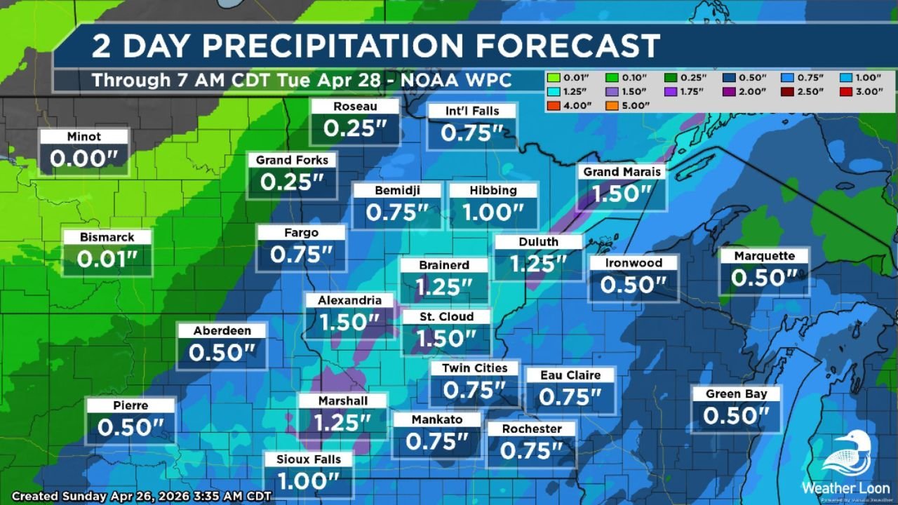
Two-Day Rainfall Totals Through 7 AM Tuesday April 28
The NOAA WPC two-day precipitation forecast shows a clear gradient of rainfall totals across the state, with the heaviest accumulations concentrated across central Minnesota:
| City | Forecast Rainfall |
|---|---|
| Alexandria | 1.50 inches |
| St. Cloud | 1.50 inches |
| Grand Marais | 1.50 inches |
| Marshall | 1.25 inches |
| Brainerd | 1.25 inches |
| Duluth | 1.25 inches |
| International Falls | 0.75 inches |
| Bemidji | 0.75 inches |
| Fargo | 0.75 inches |
| Twin Cities | 0.75 inches |
| Mankato | 0.75 inches |
| Rochester | 0.75 inches |
| Eau Claire | 0.75 inches |
| Hibbing | 1.00 inches |
| Sioux Falls | 1.00 inches |
| Ironwood | 0.50 inches |
| Aberdeen | 0.50 inches |
| Marquette | 0.50 inches |
| Green Bay | 0.50 inches |
| Grand Forks | 0.25 inches |
| Roseau | 0.25 inches |
| Pierre | 0.50 inches |
| Bismarck | 0.01 inches |
| Minot | 0.00 inches |
Drier Pattern Returns After Monday
Once the rainfall moves through by early Tuesday morning, Minnesota will transition into a quieter and drier weather pattern for the rest of the week. This stretch of calmer weather will be a welcome break following the active storm pattern that has dominated much of the region through the weekend.
Residents across central Minnesota — particularly around Alexandria, St. Cloud, Brainerd, and the Grand Marais area — should expect the heaviest rainfall totals through the event. Localized minor flooding is possible in areas that receive the highest accumulations.
Stay with CabarrusWeekly.com for continuing weather updates across Minnesota and the Upper Midwest.