Aerial Imagery Reveals EF4 Tornado Damage Swath From Oklahoma Outbreak as Damage Surveys Map Destruction From April 23 2026
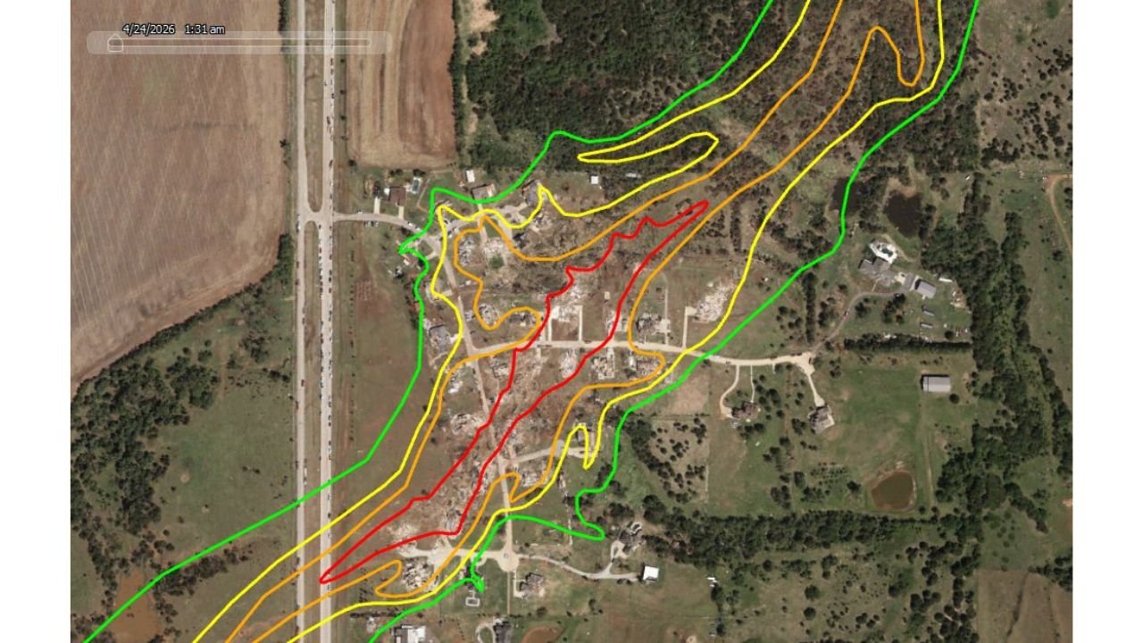
OKLAHOMA — Aerial imagery captured on April 24, 2026 and analyzed using Vexel Gray Sky satellite data has revealed the full EF-scale damage swath from one of the tornadoes produced during Thursday night’s Oklahoma severe weather outbreak, with damage ranging from EF1 through EF4 mapped across a concentrated corridor showing catastrophic destruction at the core.
EF4 Damage Confirmed at the Core
The damage polygon map — produced by analyzing high-resolution aerial imagery — shows a tornado that intensified rapidly as it moved through a populated area, with EF4-rated damage at the heart of the swath. The color-coded polygons reveal the full structure of the tornado’s damage footprint:
| EF Rating | Wind Speed | Damage Description |
|---|---|---|
| EF1 (green) | 86 to 110 mph | Outer edges — moderate damage to structures and trees |
| EF2 (yellow) | 111 to 135 mph | Significant structural damage — roofs removed, walls collapsed |
| EF3 (orange) | 136 to 165 mph | Severe structural damage — exterior walls destroyed, vehicles thrown |
| EF4 (red) | 166 to 200 mph | Catastrophic damage — well-built homes leveled to foundations |
What the Imagery Shows
The aerial photograph taken at 1:01 AM on April 24 shows a community where the central core of the tornado’s path has been stripped bare. Structures in the EF4 zone have been completely destroyed, with debris fields visible across the landscape. The EF3 zone immediately surrounding the core shows severe structural damage with walls removed and foundations exposed. The outer EF2 and EF1 rings show progressively less catastrophic but still serious damage to homes, outbuildings, and tree lines.
The width of the full damage swath — from outer EF1 boundary to outer EF1 boundary — spans a significant distance across the community, confirming this was a wide and violent tornado at its peak intensity.
Part of Thursday Night’s Outbreak
This damage survey is part of the broader assessment following Thursday night’s significant tornado outbreak across Oklahoma on April 23, 2026, which included a Tornado Emergency issued for Enid, Breckinridge, and Fairmont and produced multiple significant tornadoes across northern and central Oklahoma.
Full damage surveys and official EF ratings from the National Weather Service are expected to be released in the coming days as survey teams complete their ground assessments.
Stay with CabarrusWeekly.com for continuing coverage of tornado damage assessments and recovery efforts across Oklahoma.