Moderate Risk Severe Weather Today Brings Giant Hail, 75 MPH Winds and Tornadoes From the Plains Through the Upper Midwest
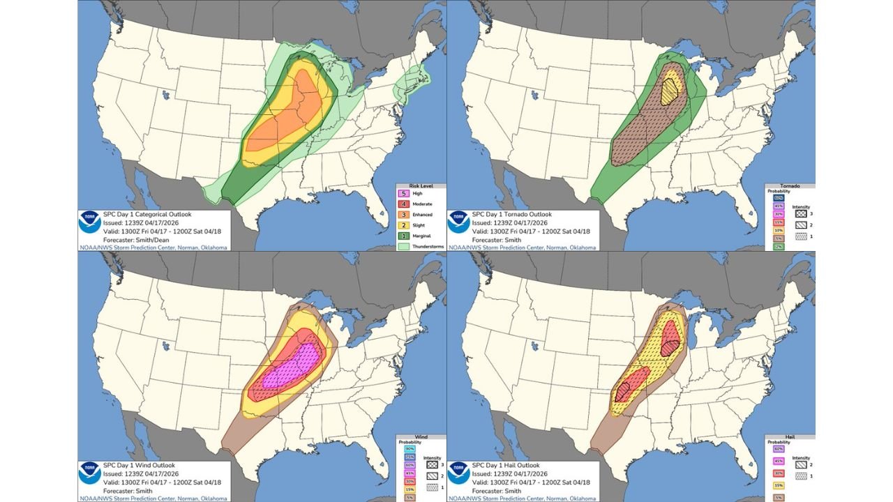
PLAINS AND UPPER MIDWEST, UNITED STATES — The SPC has issued a Moderate Risk for today Friday April 17, 2026, valid 1300Z April 17 through 1200Z April 18. Damaging winds and large to giant hail are the primary hazards across the Plains and Midwest, with a couple of strong tornadoes possible mainly across the Upper Midwest.
Three Separate Threat Maps Tell the Story
| Hazard | Highest Probability | Key Zone |
|---|---|---|
| Damaging winds | 60 to 75% with intensity hatching | Central corridor from Oklahoma through Upper Midwest |
| Large to giant hail | 45 to 60% with intensity hatching | Two separate cores across the Plains and Great Lakes |
| Tornadoes | 15 to 30% with intensity hatching | Upper Midwest focused zone |
Wind is the dominant threat today. The wind probability map shows 60 to 75% probability of damaging winds with intensity hatching across the core zone — meaning widespread and potentially destructive gusts are highly likely from the southern Plains northeast through the Great Lakes corridor.
Giant hail shows two distinct high probability cores — one across the central Plains and a second across the Great Lakes region — both with intensity hatching indicating the largest hail sizes are specifically expected.
Tornadoes are focused mainly across the Upper Midwest with the 15 to 30% probability zone carrying intensity hatching — a couple of strong tornadoes remain possible in this zone today.
The Moderate Risk categorical zone covers a large corridor from Oklahoma and Kansas northeast through Iowa, Illinois, Wisconsin, and into Michigan.
Secure outdoor property now. Get vehicles covered. Keep alerts active through tonight.
Stay with CabarrusWeekly.com for live severe weather updates across the Plains and Midwest today.