Peoria and West Central Illinois Emerge as Highest Probability Target for Monday April 27 Serious Severe Weather Event
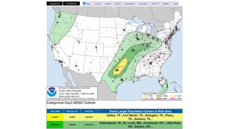
ILLINOIS — The latest machine learning severe weather probability forecast is zeroing in on west central Illinois and the Peoria area as the highest probability location for Monday’s serious severe weather event, with a maximum probability of 62.8 percent and the Peoria corridor landing in the top level of 5 on the probability scale. Each successive model update is also nudging northeast Illinois and the Chicago metro further into the elevated risk zone.
West Central Illinois Is the Bullseye
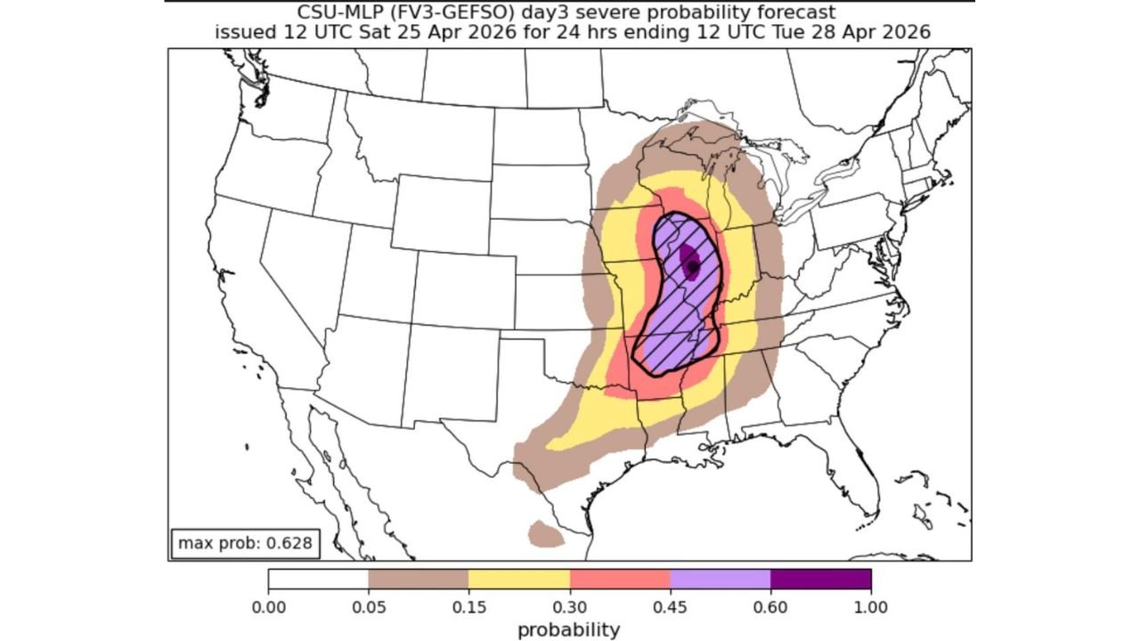
The CSU machine learning day 3 severe probability forecast issued April 25 places the peak probability dot directly over the west central Illinois region near Peoria, with the hatched highest-risk zone covering a broad swath of central and northern Illinois. The maximum probability of 0.628 — nearly 63 percent — represents an exceptionally high confidence signal at this forecast range.
Successive model runs have been consistently nudging northeast Illinois and the Chicago metro area further into the Level 3 Enhanced Risk zone, a trend that residents in those areas should take seriously as Monday approaches.
Why West Central Illinois Is the Focus
Four atmospheric ingredients are converging specifically over west central Illinois during the late afternoon into early evening hours on Monday:
Daytime heating will destabilize the atmosphere through the afternoon, building the instability needed to fuel explosive storm development. Sufficient moisture streaming northward will provide the raw fuel for severe thunderstorms. Strong upper-level winds that change direction with height — wind shear — will organize storms into rotating supercells. A strong low pressure system and trailing cold front will provide the forcing mechanism to trigger and sustain storm development.
Probability Breakdown for Monday
| Probability | Zone |
|---|---|
| 60% or greater — hatched, highest level | West central Illinois, Peoria corridor |
| 45 to 59% — purple | Broader central Illinois corridor |
| 30 to 44% — pink/red | Northern Illinois, southern Illinois, Indiana border |
| 15 to 29% — yellow | Chicago metro, Michigan, Missouri, Arkansas |
| 5 to 14% — tan | Outer fringe — Iowa, Wisconsin, Tennessee, Gulf Coast |
Chicago Metro Threat Increasing With Each Update
While the current highest probability remains focused on west central Illinois and Peoria, the consistent northeastward nudge in successive model runs is a signal that the Chicago metro area should not treat Monday as a minor event. The Level 3 Enhanced Risk for northeast Illinois is becoming increasingly likely with each update.
What Comes After Monday
Once the strong low pressure and cold front push through, a cooler air mass will settle in across Illinois from midweek through the weekend — bringing an end to the active severe weather pattern for the near term.
Monday, however, remains a day that demands full preparation and attention across the entire state. Residents from Peoria and the Quad Cities through Springfield, Bloomington, and into the Chicago metro should have shelter plans finalized, multiple warning sources active, and no outdoor commitments during the afternoon and evening hours.
Stay with CabarrusWeekly.com for continuing updates on Monday’s severe weather threat as the event approaches.