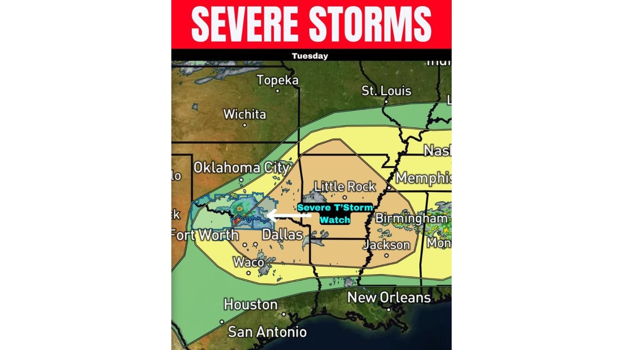
Texas, Arkansas and Louisiana Face Severe Storms Tuesday With Giant Hail Over 3 Inches and Severe Thunderstorm Watch in Effect
TEXAS, ARKANSAS AND LOUISIANA — Ongoing severe storms across Texas and Oklahoma are spreading east Tuesday, April 28, 2026, with a Severe Thunderstorm Watch already in effect for the Dallas-Fort Worth area, and an Enhanced Risk (Level 3 of 5) covering a broad corridor from north Texas through Arkansas and into Louisiana and Mississippi. Hail exceeding 3 inches in diameter is possible across the DFW region, with additional storm development expected across the ArkLaTex by 4:00 PM.
Severe Thunderstorm Watch — Dallas Fort Worth Area
A Severe Thunderstorm Watch is currently in effect for the Fort Worth and Dallas corridor as ongoing storms push eastward out of west Texas and Oklahoma. The watch area is depicted in blue on the current radar overlay, with an intense storm core already moving toward the metro area.
Forecasters are explicitly flagging the DFW region for giant hail potential — with stones exceeding 3 inches in diameter possible with the most intense supercells tracking through the area today.
ArkLaTex Development Expected by 4 PM
Additional storm development is expected across the ArkLaTex region — Arkansas, Louisiana, and Texas — by approximately 4:00 PM Tuesday. This secondary round of storms will bring:
- Large to very large hail — the dominant threat
- Damaging winds — widespread risk with any organized storm
- Isolated tornado — possible but not the primary concern
Risk Zone Breakdown for Tuesday
| Risk Level | Areas |
|---|---|
| Enhanced Risk — Level 3 | North Texas, ArkLaTex, Little Rock, Jackson Mississippi corridor |
| Slight Risk — Level 2 | Broader surrounding area including Memphis, Birmingham, Nashville fringe |
| Marginal Risk — Level 1 | Outer zones including Oklahoma City, St. Louis fringe, New Orleans |
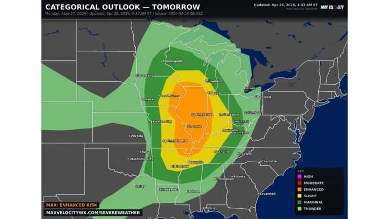
Monday Recap — Why the Tornado Outbreak Did Not Materialize
Monday’s anticipated tornado outbreak across Illinois and Missouri was significantly tempered by slightly warmer than modeled temperatures at around 750 millibars — a layer of the atmosphere that acts as a cap on storm development. That warmth prevented the robust convection needed to produce the widespread tornado outbreak that environmental data had pointed toward.
Forecasters note this outcome — while frustrating from a forecast accuracy standpoint — was a justifiable forecast miss given that all available model and environmental data had pointed strongly toward a major outbreak. Weather models simulate the entire global atmosphere and cannot capture every nuance of real-time conditions at every level. Monday’s event was a reminder that even the strongest environmental setups can be partially or fully suppressed by subtle atmospheric details that models struggle to resolve precisely.
Prepare for Tuesday’s Storms
Residents across the DFW metroplex, north Texas, Arkansas, Louisiana, and Mississippi should remain weather aware through the afternoon and evening. Vehicle protection from large hail should be secured before storms arrive, and shelter plans should be in place ahead of any severe thunderstorm or tornado warnings.
Stay with CabarrusWeekly.com for continuing coverage of Tuesday’s severe weather threat across Texas, Arkansas, and Louisiana.