Southern United States Faces Heavy Rain, Flash Flood Risk and Frost Threat Through Early May as Wettest Week of the Season Takes Shape
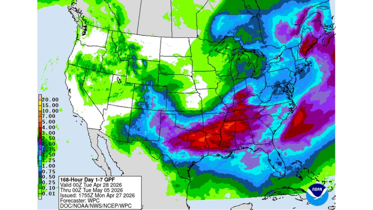
SOUTHERN UNITED STATES — The southern United States is entering its wettest stretch of the season over the next seven days, with the WPC 168-hour QPF highlighting a deep red and purple rainfall axis across Arkansas, Louisiana, Mississippi, Tennessee, and surrounding states through Tuesday May 5, accompanied by a Slight Risk of excessive rainfall and flash flooding, heavy snow in the Rockies, and a widespread frost and freeze threat across the Midwest and Northeast through early May.
Southern States Face the Heaviest Rainfall of the Next 7 Days
The WPC 7-day QPF map valid through 00Z May 5 shows the most extreme rainfall totals concentrated across a corridor stretching from Oklahoma and Arkansas through Louisiana, Mississippi, Tennessee, and into the Carolinas and Mid-Atlantic. The deep red zone — indicating 6 to 10-plus inches — is centered directly over central Arkansas, northern Louisiana, and surrounding Mid-South states.
This is the wettest region in the country over the next seven days by a significant margin.
Day 3 to 7 Hazards Outlook — April 30 Through May 4
The WPC Hazards Outlook valid April 30 through May 4 identifies multiple simultaneous hazards across the country:
| Hazard | Dates | Areas |
|---|---|---|
| Heavy Rain | April 30 to May 1 | Southern Plains through Mid-South |
| Heavy Rain | May 1 | Central Mississippi Valley |
| Heavy Rain | May 2 | Southeast and Gulf Coast |
| Heavy Snow | April 30 to May 1 | Central Rockies |
| Frost and Freeze | April 30 to May 2 | Upper Midwest and Great Lakes |
| Frost and Freeze | May 1 to May 3 | Ohio Valley and mid-Atlantic |
| Frost and Freeze | May 3 | Coastal Northeast |
| Heavy Rain | April 30 | Maine and northern New England |
Flash Flood Risk — Slight Risk in Place Tuesday
The Day 2 Excessive Rainfall Outlook valid through 12Z Wednesday April 29 places a Slight Risk of excessive rainfall — meaning at least a 15 percent probability of rainfall exceeding flash flood guidance — across a corridor covering Arkansas, Tennessee, Mississippi, Kentucky, and surrounding areas. A broader Marginal Risk extends the flash flooding concern into Louisiana, Texas, and the broader Mid-South.
With multiple rounds of heavy rain expected over already saturated or rapidly saturating ground, flash flooding is a serious concern across the core zone through the middle of the week.
Frost and Freeze Threat Extends Through Early May
As the active rain pattern dominates the South, a sharp cold air mass is simultaneously settling across the Midwest, Ohio Valley, and Northeast. The WPC minimum temperature forecast for Saturday May 2 shows widespread overnight lows in the 29 to 38 degree range across the Great Lakes, Ohio Valley, and Mid-Atlantic — well below freezing for many locations.
Frost and freeze warnings are expected to be a recurring concern from April 30 through at least May 3 across a broad swath of the central and eastern United States. Early-season plantings and agricultural interests across Indiana, Ohio, Kentucky, Pennsylvania, and surrounding states are at significant risk through this period.
Heavy Snow for the Rockies
The Rocky Mountain region faces a separate hazard with heavy snow expected April 30 through May 1 across the central Rockies — a classic late-season upslope snow event consistent with the overall cool and active pattern dominating the country through early May.
Summary of the Week Ahead
| Region | Primary Concern | Timing |
|---|---|---|
| Arkansas, Louisiana, Mississippi | Extreme rainfall totals 6 to 10-plus inches, flash flooding | April 28 through May 5 |
| Tennessee, Kentucky, Carolinas | Heavy rain, flash flood risk | April 30 through May 3 |
| Midwest and Ohio Valley | Frost and freeze, lows in the 29 to 38 degree range | April 30 through May 3 |
| Central Rockies | Heavy snow | April 30 to May 1 |
| Northeast | Frost and freeze | May 3 |
Stay with CabarrusWeekly.com for continuing day-by-day coverage of this significant multi-hazard weather pattern across the United States through early May.