Mid-Atlantic, Carolinas, and Southeast Face Evening Storm Threat This Wednesday With Isolated Tornado Possible Between 5 and 11 PM
UNITED STATES — Showers and thunderstorms are expected to push through a large portion of the Eastern United States on Wednesday, April 29, 2026, with the window of greatest activity running mainly between 5 and 11 p.m. A slight chance of an isolated tornado exists if conditions allow enough sunshine to warm the atmosphere ahead of the front.
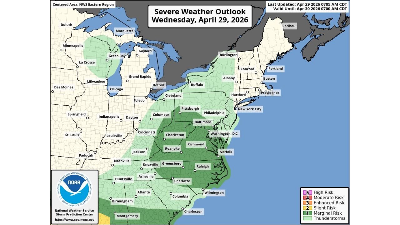
A Level 1 Out of 5 Risk Covers a Wide Stretch of the East
The National Weather Service Storm Prediction Center has placed the region under a Level 1 out of 5 — Marginal Risk for severe storms, valid through April 30, 2026 at 7:00 AM CDT. The risk zone covers a broad north-to-south corridor spanning from parts of the Ohio Valley and Mid-Atlantic down through the Carolinas, Tennessee, and into Alabama and Georgia.
Cities within or near the risk area include Pittsburgh, Columbus, Charleston, Washington D.C., Baltimore, Philadelphia, Richmond, Roanoke, Norfolk, Charlotte, Greensboro, Raleigh, Wilmington, Knoxville, Asheville, Atlanta, Birmingham, Huntsville, Nashville, and Montgomery.
The Key Factor That Will Determine How Strong Storms Get
The limiting factor for storm development is fuel. Little sunshine is expected during the day, which reduces the atmospheric heating needed to generate severe storms. However, if temperatures manage to warm to near 70 degrees, there is ample wind shear — the turning of winds with altitude — to support rotating storms.
In that scenario, an isolated tornado could form as showers and storms move through. If clouds dominate and temperatures stay cooler, the tornado threat remains very low and most activity stays below severe levels.
What Most People Will Experience This Wednesday Evening
The primary hazard for the majority of the region will be heavy showers, lightning, and gusty winds between 5 and 11 p.m. Rainfall amounts will vary but are expected to average between 0.5 and 0.75 inches across the affected area.
The main question heading into the evening is whether any storms will reach severe limits — a scenario that depends heavily on how much daytime heating occurs before the front pushes through.
Hazards Possible With the Stronger Storms
- Downpours and heavy rainfall
- Lightning
- Gusty winds
- Isolated tornado — if sufficient daytime heating occurs
When to Watch Closely Wednesday Night
The storm window opens this evening and runs mainly from 5 p.m. through 11 p.m. The front driving this activity is described as a strong one, meaning storm development is likely once it moves through — the degree of severity will depend on conditions ahead of it.
The outlook is valid through April 30, 2026 at 7:00 AM CDT, covering overnight activity as the system continues to exit the region.
Stay with CabarrusWeekly.com for continuing updates as this evening storm system moves through the Mid-Atlantic, Carolinas, and Southeast.