Texas and Gulf Coastal States Face Heavy Rainfall Late Week as Cold Front Funnels Gulf Moisture With Locally 6 Inches Possible
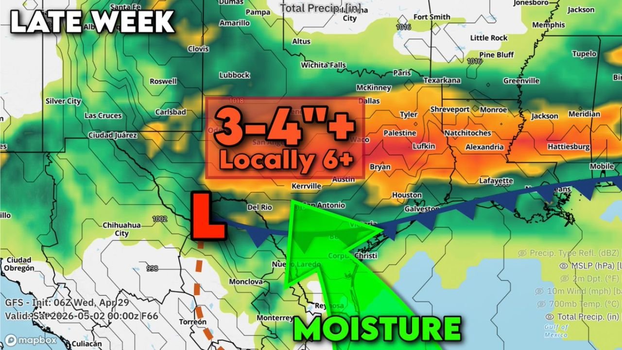
UNITED STATES — A slow-moving cold front drifting south through late week is expected to focus a surge of Gulf moisture across Texas and the Gulf Coastal states, setting up the potential for significant heavy rainfall by the end of the week. General rainfall totals of 3 to 4 inches are likely across the region, with locally 6 inches or more possible in the hardest-hit areas.
What Is Setting This Up Late Week
A saggy cold front is slowly drifting southward and will act as a focal point for Gulf moisture streaming northward into the region. As that moisture gets drawn in and concentrated along the front, heavy and repeated rounds of rainfall become likely across a wide zone.
Model data initialized Wednesday, April 29, 2026 and valid through Saturday, May 2, 2026 shows the heaviest precipitation signal centered across a corridor from the Edwards Plateau through East Texas and into the Gulf Coastal states, including areas around Kerrville, San Antonio, Austin, Waco, Dallas, Lufkin, Natchitoches, Alexandria, Lafayette, and toward Mobile.
The Rainfall Totals Being Forecast
The heaviest rainfall footprint stretches across central and east Texas and into Louisiana and the Gulf Coast. Forecast totals show:
- General rainfall: 3 to 4 inches across the primary affected zone
- Locally 6 inches or more in areas where training storms or the front stalls
The moisture transport signal is strong, with a pronounced flow of Gulf moisture surging northward from the coast into the Texas interior. Dew point data valid Friday, May 1, 2026 shows highly humid conditions already established across South Texas, the Rio Grande Valley, and the Coastal Bend, with the moisture plume extending northward toward San Antonio, Austin, and beyond.
The Cities and Areas Most at Risk
Based on the precipitation and moisture transport data, the zone at greatest risk for heavy rainfall includes:
Kerrville, San Antonio, Austin, Waco, Dallas, Tyler, Palestine, Bryan, Houston, Galveston, Lufkin, Natchitoches, Alexandria, Shreveport, Lafayette, and Mobile.
Moisture streaming in from the Gulf is focused tightly along and north of the front, keeping the heaviest rainfall threat concentrated across this corridor from the Edwards Plateau eastward through the Gulf Coastal states.
Why This Rainfall Event Deserves Attention
The combination of a stalling or slow-moving front, a deep and sustained Gulf moisture feed, and back-to-back rounds of storms creates the conditions for rainfall totals to add up quickly. Areas that see repeated storm activity over the same locations are most at risk for reaching or exceeding the 6-inch locally threshold.
Flash flooding will be a concern across low-lying areas, urban zones, and any region that has seen recent rainfall leading into this event.
The Timeline: When to Expect the Heaviest Rain
Model data places the heaviest rainfall signal arriving late week, with the GFS showing the precipitation footprint fully established by Saturday, May 2, 2026. The HRRR model valid Friday, May 1, 2026 shows the moisture transport and front already well in place across South and Central Texas by that point, with the heavy rain zone pushing eastward through the day.
Conditions are expected to remain unsettled across the Gulf Coastal states through at least the first weekend of May as the front continues to interact with the Gulf moisture plume.
Stay with CabarrusWeekly.com for continuing updates as this late-week heavy rain event develops across Texas and the Gulf Coast.