Central Florida Faces Hot Days, Thursday Storms North of Orlando, Then a Dramatic Cool Down From 93 to 78 Degrees This Weekend
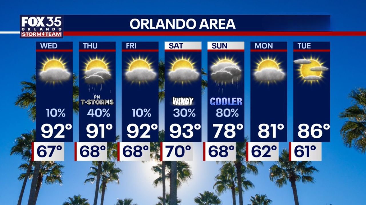
CENTRAL FLORIDA — A week of significant weather swings is ahead for Central Florida, beginning with hot temperatures pushing into the low 90s through the week, a thunderstorm threat north of Orlando on Thursday, a windy Saturday, and then a dramatic cool down on Sunday that will drop highs from the mid-90s all the way down to 78 degrees with an 80 percent chance of rain.
Hot Temperatures Continue Through the Week
Temperatures across the Orlando area will remain well above average through the end of the week. The seven-day forecast shows:
| Day | High | Low | Conditions |
|---|---|---|---|
| Wednesday | 92° | 67° | Partly cloudy, 10% rain |
| Thursday | 91° | 68° | PM thunderstorms, 40% |
| Friday | 92° | 68° | Mostly sunny, 10% |
| Saturday | 93° | 70° | Windy, 30% |
| Sunday | 78° | 68° | Cooler, rainy, 80% |
| Monday | 81° | 62° | Partly cloudy |
| Tuesday | 86° | 61° | Partly cloudy |
Thursday Storm Threat Focused North of Orlando
The primary storm concern this week falls on Thursday afternoon and evening, and it is focused specifically on counties north of Orlando. The area to watch includes Flagler, Volusia, Marion, and Alachua counties, where thunderstorms tracking southeast are possible during the afternoon and evening hours.
Areas further south including Orlando, Apopka, Dade City, Lakeland, and the Space Coast are expected to remain likely dry on Thursday. The storm threat is concentrated across the northern zone outlined in the forecast, including Ocala, The Villages, Deltona, Daytona Beach, and Palm Coast.
What Thursday Evening Radar Shows
Forecast radar valid Thursday, April 30 at 5:30 PM shows storm cells developing across the Ocala, Gainesville, Deltona, and Daytona Beach corridor, with the most intense activity pushing southeast through Volusia County toward the coast. Orlando and areas to the south remain largely clear of activity at this time frame.
Saturday Turns Windy Before the Big Change
Ahead of the approaching front, Saturday brings windy conditions with a high of 93 degrees and a 30 percent rain chance. This will be the last of the heat before the front sweeps through.
Sunday Brings a Dramatic and Rare Cool Down
The most significant weather shift of the week arrives Sunday, when a frontal passage drops temperatures from 93 degrees Saturday all the way down to a high of just 78 degrees — a drop of 15 degrees in a single day. Rain chances climb to 80 percent on Sunday, making it the wettest day of the forecast period.
As noted, it is not often that Orlando sees a swing from the mid-90s to the 70s for highs in May — making this an unusually sharp cold front for the time of year.
Stay with CabarrusWeekly.com for continuing updates on the Central Florida forecast through the weekend.