Washington D.C. Faces a Much Cooler May After Fourth Warmest April on Record as Temperatures Expected to Run 2 to 5 Degrees Below Normal
WASHINGTON D.C. — After closing out April 2026 as the fourth warmest April on record with an average temperature of 62 degrees — about 4 degrees above normal — the nation’s capital is heading into a drastically different pattern for May. Morning lows in the frosty 30s greeted many residents on the first day of the new month, signaling the sharp change already underway.
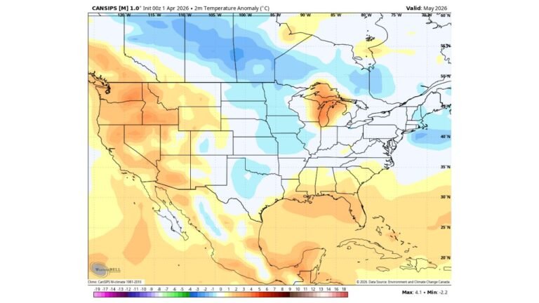
What May Is Projected to Look Like for D.C.
May is forecast to average 2 to 5 degrees below normal across the Washington D.C. area, with a projected average temperature of 62 to 65 degrees. In a remarkable turn, May could end up no warmer on average than April — an unusual outcome given that May is typically several degrees warmer than April across the region.
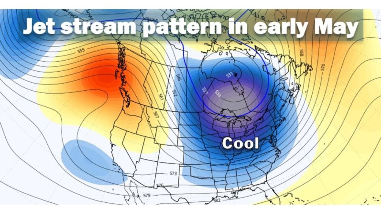
The jet stream pattern driving this outcome shows a deep trough locked over the eastern half of the country during early May, with a strong ridge positioned along the West Coast. This setup funnels cool air southward across the Midwest, Ohio Valley, Mid-Atlantic, and Northeast, keeping temperatures suppressed well below what is typical for the month.
Rainfall Has Been Critically Low for Nearly a Year
Beyond the temperature story, the rainfall picture for D.C. is deeply concerning. April marked the 10th month out of the last 11 with below normal rainfall, with the region receiving less than half the typical rainfall amount during April. This sustained dry stretch has compounded drought conditions across the region heading into spring.
May is not expected to be quite as dry as April, but rainfall will likely still lean slightly below to near normal for the month — offering limited relief from the prolonged dry pattern.
The Jet Stream Pattern Driving the Cool Down
The early May jet stream pattern shows a strong upper-level trough centered over eastern Canada and the northeastern United States, with the cold anomaly extending southward across much of the eastern US. This pattern is the primary driver of the cool and unsettled conditions expected to dominate the D.C. area and much of the East through the opening weeks of May.
A Remarkable Contrast to April
The shift from April to May represents one of the sharpest month-to-month temperature pattern changes in recent memory for the D.C. region. April finished 4 degrees above normal and ranked as the fourth warmest on record. May is now projected to run 2 to 5 degrees below normal — a swing of up to 9 degrees in the average temperature departure from one month to the next.
Stay with CabarrusWeekly.com for continuing updates on the May temperature and rainfall outlook for Washington D.C. and the surrounding region.