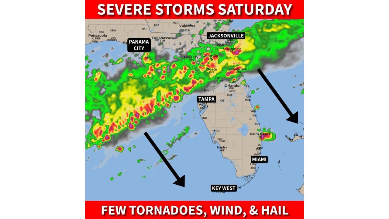
Florida Panhandle to Miami Face Tornadoes, Damaging Winds and Large Hail Saturday as Squall Line Pushes South Through the Peninsula
FLORIDA — A strong cold front is bringing a significant severe weather threat to Florida on Saturday, May 2, 2026, with the danger beginning in the Panhandle in the morning and pushing southward through the Peninsula into the afternoon and evening. A few tornadoes — possibly strong — are a concern alongside damaging winds and large hail as the squall line moves through the state.
How the Storm System Will Move Saturday
The squall line will begin its push through Florida’s Panhandle during the morning hours, tracking through Pensacola, Panama City, and Tallahassee before driving southward into the Peninsula through the afternoon. By evening, the line is expected to push through Tampa, Orlando, Jacksonville, Daytona Beach, and toward Palm Beach and Miami.
A few rogue storms could develop ahead of the main line as well, adding to the threat window for communities in central and south Florida.
The Hazards to Watch Saturday
Residents across Florida should prepare for the following hazards:
- A few tornadoes — possibly strong
- Damaging winds
- Large hail
- Heavy rainfall
Having multiple ways to receive warnings is strongly recommended given the tornado threat embedded in the squall line.
City by City Timeline
Morning — Panhandle: Pensacola, Panama City, and Tallahassee face the earliest threat as the squall line enters from the northwest.
Afternoon — North and Central Florida: The line pushes through Jacksonville, St. Augustine, Gainesville, Ocala, Cross City, and Orlando during the afternoon hours. Radar shows intense cells concentrated across this corridor.
Evening — South Florida: By evening the line reaches Tampa, Daytona Beach, Palm Beach, and Miami, with the system expected to weaken as it pushes into South Florida and the Keys on Sunday — though Sunday still looks soggy for those areas.
Sunday Outlook for South Florida and the Keys
The squall line is expected to weaken as it pushes into South Florida and the Keys on Sunday, but the system will still likely produce a soggy and unsettled Sunday for communities from Miami southward through Key West.
Stay with CabarrusWeekly.com for continuing updates as this severe weather system moves through Florida on Saturday.