Colorado Faces Scattered Showers Tuesday Before Significant Spring Storm Brings Snow and Severe Storms Wednesday Through Friday
COLORADO AND DENVER FRONT RANGE — A weak front is pushing through Colorado today, Tuesday, April 28, 2026, bringing scattered showers and isolated thunderstorms mainly along and north of I-70, before a more significant and complex storm system arrives Wednesday and produces widespread precipitation, potential wet snow as low as 5,000 feet, and strong to severe thunderstorms across portions of the state through Friday.
Today — Scattered Showers Along and North of I-70
A weak front is sliding through Colorado today, keeping scattered to widely scattered showers across the region. Snow levels are starting near 5,500 feet this morning before a few afternoon thunderstorms develop with daytime heating — primarily along and north of I-70. Southern Colorado and southern Kansas remain drier today. Temperatures are similar to Monday with nothing extreme expected.
Wednesday — Storm System Arrives, Showers Increase
Temperatures nudge up slightly Wednesday ahead of the incoming system. Showers begin developing Wednesday afternoon as the next storm approaches, with precipitation becoming widespread Wednesday night into Thursday and lingering into Friday.
The setup involves a cold front dropping from the north linking up with a storm system emerging from the Desert Southwest — a combination that can produce complex and impactful weather across Colorado quickly.
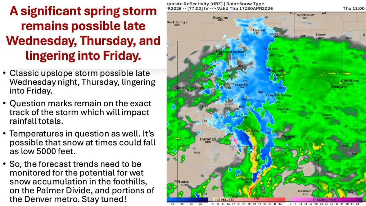
Wednesday Night Through Friday — Significant Spring Storm
A significant spring storm remains possible from late Wednesday night through Thursday and lingering into Friday, with the following breakdown by elevation:
| Zone | Expected Precipitation Type |
|---|---|
| Mountains and higher foothills | Snow |
| Lower elevations below 5,000 feet | Rain |
| Palmer Divide and higher west and south Denver metro around 6,000 feet | Rain mixing with or changing to wet snow |
| Far southern and southeast Colorado | Potential for strong to severe thunderstorms on the system’s edge |
Snow could potentially fall as low as 5,000 feet depending on how temperatures evolve — a critical uncertainty that forecasters are continuing to monitor. Wet snow accumulation is possible on the Palmer Divide, in the foothills, and in portions of the Denver metro depending on storm track.
Key Uncertainties Still Remain
Several moving parts will determine the final storm impacts:
- Storm track — will significantly influence where the heaviest precipitation falls
- Temperatures — will determine rain versus snow ratios and accumulation potential
- Timing — storm duration and intensity are still being refined
- Severe threat — southern and southeast Colorado face a strong to severe thunderstorm risk on the southern edge of the system
Rainfall totals and potential snow amounts will come into sharper focus as the week progresses and the storm track tightens.
After Friday — Continued Unsettled Pattern Into May
The unsettled weather does not fully clear after Friday. Continued potential for scattered showers exists as the calendar rolls into May, suggesting the active and cool pattern will persist across Colorado into the early part of next month.
Monitor forecasts closely through Wednesday and stay with CabarrusWeekly.com for continuing updates on Colorado’s significant spring storm threat.