Illinois Faces Increasing Showers and Downpours Thursday Afternoon as a Low-Level Jet Drives Storm Activity Through the Peoria and Bloomington Corridor
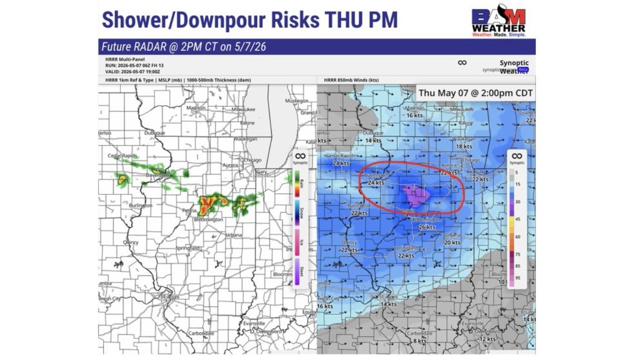
ILLINOIS — Increasing showers and downpours are expected to develop across central Illinois on Thursday afternoon and evening, May 7, 2026, driven by a strengthening low-level jet pushing moisture and storm activity through the Peoria and Bloomington corridor. Simulated radar valid at 2:00 PM CDT shows the heaviest activity concentrated across central Illinois with the low-level jet identified as the primary driver.
The Low-Level Jet Is the Culprit
The 850mb wind forecast valid Thursday May 7 at 2:00 PM CDT shows a concentrated zone of enhanced winds circled directly over central Illinois, with values of 22 to 26 knots focused tightly around the Peoria, Bloomington, and Davenport corridor. This low-level jet is feeding moisture and energy directly into the developing shower and downpour activity across the region.
Wind values across the broader area range from 14 to 22 knots across northern Illinois near Chicago, Aurora, and Rockford, weakening to 16 knots further south toward Evansville.
Where the Heaviest Rain Is Forecast Thursday Afternoon
The simulated radar valid at 2:00 PM CDT on May 7 shows a focused band of moderate to heavy rainfall stretching across central Illinois, with the highest intensity returns centered near Peoria and eastward through Bloomington. Lighter scattered activity extends toward the Chicago metro and into portions of Indiana.
The HRRR model run from 10Z on May 7 and valid at 20:00Z shows this activity well established across the central Illinois corridor by the afternoon hours.
Timing of the Threat Thursday
| Time | Activity |
|---|---|
| Thursday afternoon 2:00 PM CDT | Showers and downpours developing across central Illinois near Peoria and Bloomington |
| Thursday evening | Continued shower and downpour activity possible as low-level jet remains in place |
What Residents Should Expect
Communities across central Illinois including Peoria, Bloomington, and the surrounding corridor should expect periods of heavy rain and downpours during the afternoon and evening hours on Thursday. Localized nuisance flooding of low-lying areas and roadways is possible where the heaviest rain concentrates.
Residents further north toward Chicago, Aurora, and Davenport face a lower but non-zero risk of scattered shower activity through the same period.
Stay with CabarrusWeekly.com for continuing updates on Thursday’s shower and downpour threat across Illinois.